Bioko (island of Equatorial Guinea)
Bioko is a volcanic island in the Gulf of Guinea, the northernmost province of Equatorial Guinea. It hosts the national capital Malabo, high tropical forests, endemic wildlife and offshore energy resources.
Overview
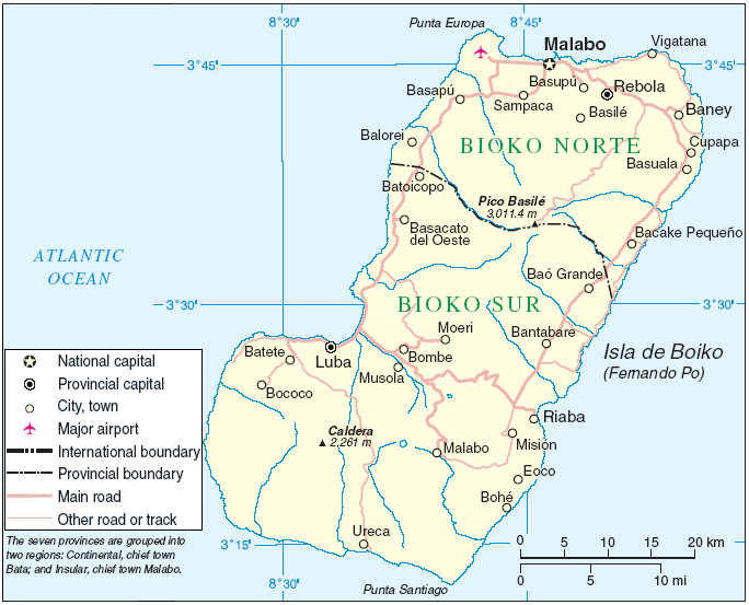
Bioko is an island located off the west coast of Africa in the Bight of Bonny, forming the northernmost part of Equatorial Guinea. It lies roughly 32 km from the continental shoreline; general maps and location resources show its position in the eastern Gulf of Guinea (map and location). The island’s coast is indented with bays and small harbors and the principal urban centre is the city of Malabo on the north coast, which functions as the country’s main administrative and commercial centre.
Image gallery
10 Images


Geology and climate
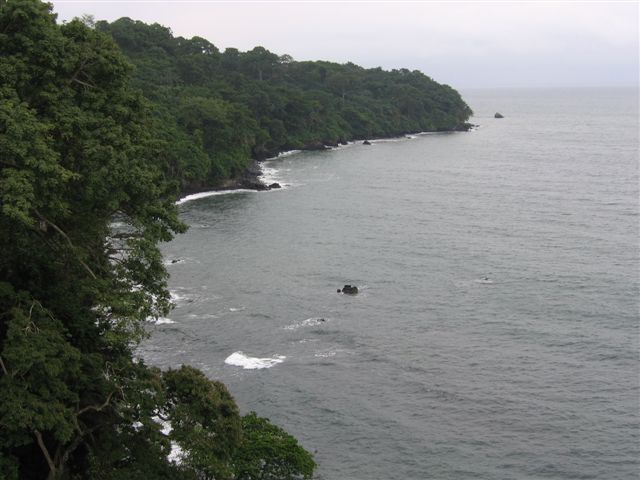
Bioko is volcanic in origin and part of the Cameroon volcanic line, a chain of volcanic centres stretching from the Gulf of Guinea onto the continental mainland. The interior is mountainous, with steep slopes and volcanic cones; the highest summit, Pico Basile, rises to about 3,012 m. Elevation and exposure to moist oceanic air produce a range of climate zones from hot, humid coastal lowlands to cooler, cloud-forested highlands. Rainfall is typically heavy for much of the year, supporting lush tropical vegetation.
Environment and biodiversity
The island’s humid forests and montane zones support a rich assemblage of plants and animals, including species and populations found only on Bioko or nearby islets. Forests harbor a variety of primates, forest birds and other mammals; conservation groups monitor endemic and threatened taxa and promote habitat protection to address pressure from hunting, settlement and agricultural expansion. Higher-elevation forests often have distinct assemblages and can include cloud forest communities.
People, history and culture
Bioko has been inhabited for centuries by local groups such as the Bubi people. European contact began in the 15th century and later colonial periods introduced Portuguese and Spanish influence; older historical sources and maps commonly refer to the island as Fernando Po. Over time the island’s population has become more diverse through migration from the mainland. Malabo remains the principal city and a focal point for administration, trade and services.
Economy and transport
The island’s economy combines urban services with agriculture on coastal plains and plantations that have produced crops such as cocoa historically. In recent decades offshore oil and gas discoveries in the Gulf of Guinea region have become economically important for Equatorial Guinea and for activities based from Bioko. Transport connections include the island’s international airport and maritime links to the mainland; local roads connect Malabo with other settlements.
Key facts
- Area: about 2,017 km2.
- Dimensions: roughly 70 km long and 32 km across at its widest point.
- Highest point: Pico Basile, c. 3,012 m.
- Location: northernmost province of Equatorial Guinea, in the Gulf of Guinea and the West African coast.
- Principal city: Malabo; national context and administration are discussed under Equatorial Guinea.
For a general orientation and additional geographic detail consult mapping resources and regional overviews that cover the island’s place in the Gulf of Guinea and off the West African coast. Further administrative and historical information is available in records about Equatorial Guinea.
Maps and navigational references showing Bioko’s position relative to the mainland and neighbouring islands can be consulted via general mapping tools (map and location) and maritime guides to the Gulf of Guinea.
Questions and answers
Q: Where is Bioko located?
A: Bioko is located 32km off the west coast of Africa, in the Bight of Bonny part of the Gulf of Guinea.
Q: What country does Bioko belong to?
A: Bioko is the northernmost part of Equatorial Guinea.
Q: What is the total area of Bioko?
A: Bioko has a total area of 2,017km2 (779 sq mi).
Q: What is the length of Bioko?
A: Bioko is 70km (43 mi) long.
Q: What is the highest peak in Bioko?
A: The highest peak in Bioko is Pico Basile, which is 3,012m (9,882ft).
Q: How wide is Bioko?
A: Bioko is about 32km (20 mi) across.
Q: What body of water is Bioko located in?
A: Bioko is located in the Bight of Bonny part of the Gulf of Guinea.
Tags
Related articles
Author
AlegsaOnline.com Bioko (island of Equatorial Guinea) Leandro Alegsa
URL: https://en.alegsaonline.com/art/11640