Adyar River (Chennai, India)
A short river that runs through Chennai, India. About 42.5 km long, it forms a tidal estuary and creek at its mouth but is affected by urban pollution and targeted by restoration projects.
Overview
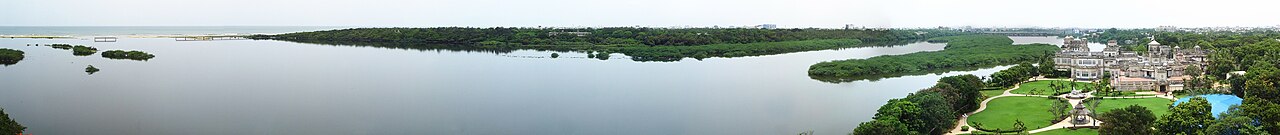
The Adyar River is a short but significant watercourse that flows through the metropolitan area of Chennai in the Indian state of Tamil Nadu. Its length is commonly given as about 42.5 kilometres and its catchment drains a large, predominantly urbanised area. The river collects overflow from a network of tanks, lakes and drains, and finally discharges into the sea, creating a tidal estuary at its mouth that supports an estuarine ecosystem. Although much altered by development, the river remains a notable geographic feature of the city.
Image gallery
10 Images


Course and physical characteristics
Adyar rises in the inland lowlands of the region, in the vicinity of the Malaipattu tank near Manimangalam and receives additional inflows from the large Chembarambakkam Lake before appearing as a continuous stream. It traverses the districts of Kanchipuram, Tiruvallur and Chennai before entering the Bay of Bengal at the neighbourhood of Adyar. The final reach includes a backwater or creek formed by a sandbar at the mouth; this channel carries tidal water inland for several kilometres and moderates salinity and water levels in the lower river. In parts of the central city the channel broadens substantially, allowing tidal influence and seasonal flushing.
Ecology and estuary
The lower Adyar opens into an estuarine area of mixed saline and fresh water, with mudflats, mud islands and mangrove patches that host a variety of waterbirds and intertidal species. That estuarine zone has been recognised for its ecological value: a portion of the creek and adjoining wetlands was declared a protected wildlife area in the late 20th century, aimed at conserving the local biodiversity. The estuary’s condition is shaped by tides, river discharge and the accumulation of sediments that can form sandbars at the mouth, producing the familiar creek and backwater formation near the coast.
Hydrology and urban impacts
The Adyar’s basin receives surplus water from roughly two hundred tanks and small lakes, as well as from rainwater drains across the city, contributing to a combined catchment on the order of several hundred square kilometres. Urban expansion, industrial activity and inadequate sewage infrastructure have altered both water quality and flow. A substantial fraction of the city’s municipal waste and effluent reaches the Adyar and its neighbouring waterways; estimates have placed the distribution of untreated sewage among Chennai’s main channels with the Adyar receiving a smaller share compared with the Buckingham Canal and the Cooum River, which together take the larger portions. These inputs have led to eutrophication, foul odours, and reduced oxygen levels that damage aquatic life.
Management, restoration and hazards
Authorities and civic groups have identified several management priorities: preventing the formation of blocking sandbars at the mouth, reducing sewage and industrial discharges, and restoring wetlands in the lower reaches. Structural measures such as groynes to stabilise the channel near the mouth have been proposed to maintain navigation and tidal exchange while flood-control works aim to reduce inundation during heavy monsoon rains. In the early 2010s, municipal and state initiatives allocated significant funding for sewage interception and cleaning systems at many points along the city’s waterways, including multiple installations on the Adyar. These interventions are part of a broader effort to rehabilitate urban water bodies and to reduce public-health and environmental risks.
Uses, cultural importance and notable facts
Despite its degraded state in many stretches, the Adyar continues to be used locally for small-scale fishing and occasional boating in sections where water quality and depth permit. The estuary and creek remain important as urban green and blue spaces that support migratory and resident birds, and as a buffer that moderates coastal hydrology. Important distinctions include the river’s relatively short length compared with major Indian rivers, its role in draining a densely populated metropolitan area, and the coexistence of an ecologically protected estuarine reserve within an otherwise heavily urbanised setting. Ongoing monitoring and community engagement are widely regarded as essential to any long-term recovery of the river.
- Length: about 42.5 km; catchment: several hundred sq km.
- Source region: Malaipattu tank / Chembarambakkam Lake.
- Mouth: estuary and creek at Adyar into the sea.
- Nearby waterways: Cooum River (Cooum) and Buckingham Canal (Buckingham Canal).
- Environmental concerns: urban waste and sedimentation; municipal cleanup programs and infrastructure upgrades remain active priorities (waste management, habitat protection).
Questions and answers
Q: Where does the Adyar River originate?
A: The Adyar River originates near the Chembarambakkam Lake in Kanchipuram district.
Q: How long is the Adyar River?
A: The Adyar River is 42.5 kilometres (26.4 miles) long.
Q: What kind of activities take place in the river despite its high pollution levels?
A: Despite its high pollution levels, boating and fishing take place in the Adyar River.
Q: What is the combined catchment area of all sources that feed into the river?
A: The combined catchment area of all sources that feed into the Adyar River is 860 square kilometres (331 sq mi).
Q: Where does most of the waste from Chennai get drained to?
A: Most of the waste from Chennai gets drained into both the Adyar River and Cooum River.
Q: How far away from Tambaram is it located?
A: The Adyar River is located about 15 kilometres (9 miles) west of Tambaram near Chennai.
Q: What measures were taken by government to reduce sedimentation in 2011?
A: In 2011, Water Resources Department proposed to construct groynes to reduce formation of sand bars near mouth of river and prevent inundation during monsoon season.
Tags
Related articles
Author
AlegsaOnline.com Adyar River (Chennai, India) Leandro Alegsa
URL: https://en.alegsaonline.com/art/1129