2006 Atlantic hurricane season
Summary of the 2006 Atlantic hurricane season: dates, storm and hurricane counts, meteorological influences (El Niño, Saharan Air Layer), notable records such as Zeta's calendar-year carryover, and impacts.
Overview
The 2006 Atlantic hurricane season formed part of the annual cycle of tropical cyclone activity in the Atlantic basin. The season officially ran from June 1 to November 30 of 2006. It followed a hyperactive 2005 season and produced a more moderate level of activity. In broad terms, a tropical cyclone is a rotating low-pressure system that forms over warm tropical or subtropical waters; general background material is available from regional tropical cyclone resources.
Image gallery
10 Images


Season summary and statistics
Official counts for the season recorded ten tropical storms and five hurricanes. In addition, one system was identified operationally as a tropical storm but was not given a name in real time and is commonly referred to as an unnamed storm in post-season analyses. The season produced fewer intense systems than the preceding year and fewer late-season formations after early October.
- Total tropical storms: 10 (plus one unnamed)
- Total hurricanes: 5
- Major hurricanes: activity was lower than in 2005 and major hurricane formation was limited
Meteorological influences
Several large-scale climate factors influenced the 2006 season. Forecasters who began the year still expected above-average activity compared with long-term climatology because of momentum from 2005, but the development of an El Niño episode in the tropical Pacific increased vertical wind shear over the Atlantic, a factor that suppresses cyclone intensification. At the same time, the Saharan Air Layer — a dry, dusty airmass that moves off northwest Africa — was present over parts of the tropical Atlantic and is known to inhibit thunderstorm development within nascent disturbances (Saharan Air Layer).
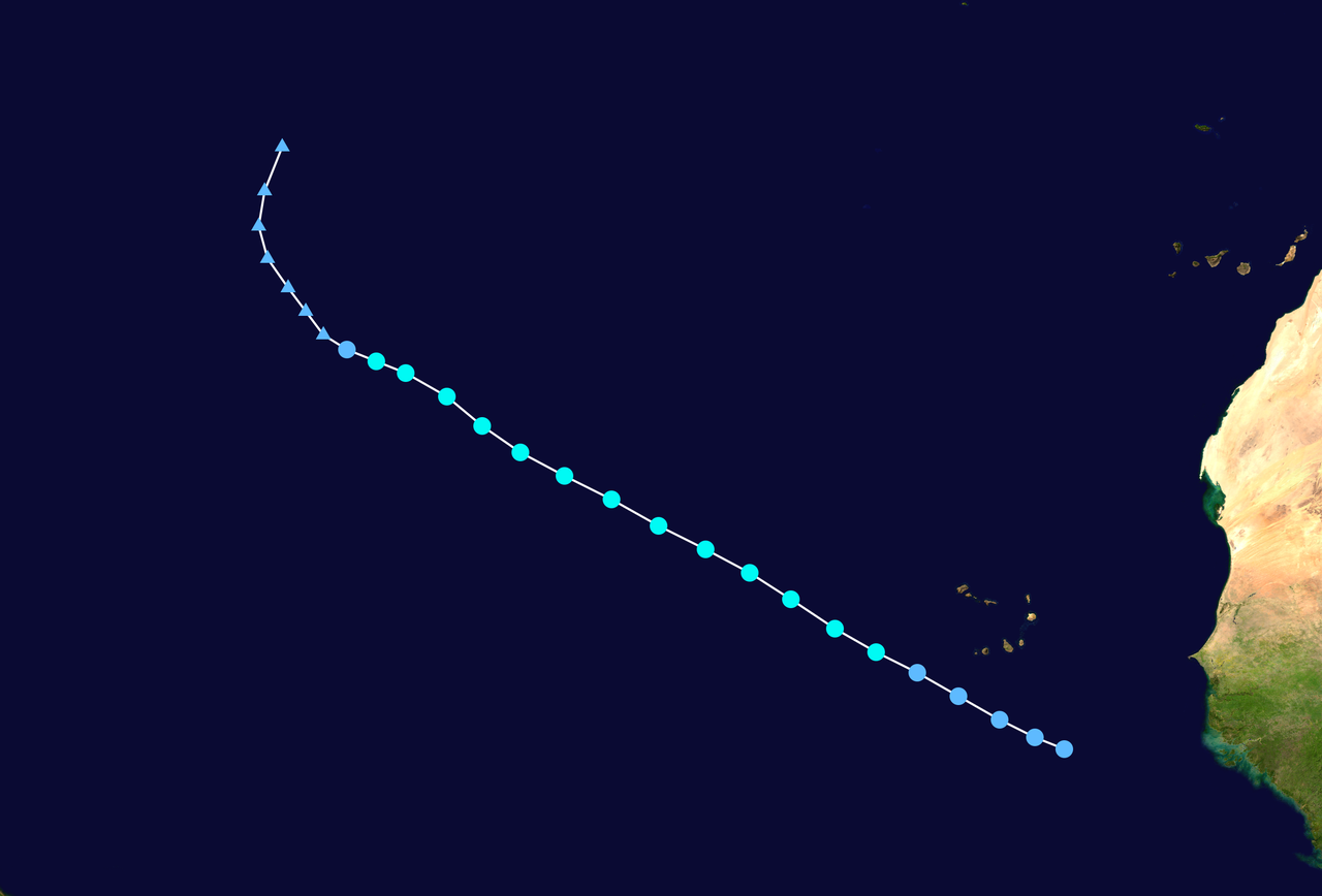
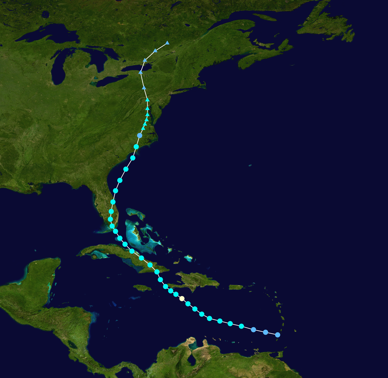
Tracks, impacts and notable features
One unusual aspect of the season was that no hurricanes made landfall on the continental United States. Several systems remained over open water or weakened before reaching the U.S. coastline, though some storms and their remnants produced rain and minor coastal effects in the Caribbean, the Bahamas, and portions of the southeastern United States, including Florida. Another notable historical point involved a system that carried over the calendar year boundary: Tropical Storm Zeta, which originated during the 2005 season, persisted into January, making it one of the rare tropical cyclones to occur in two calendar years.
Timing and late-season behavior
Most activity in 2006 occurred during the typical peak window of the season in late summer and early autumn. Observational summaries indicate that formation and sustained intensification declined markedly after early October; analyses often note reduced cyclone genesis and quicker dissipation of systems after October 2. By the official season end on November 30, overall activity had returned closer to a more average level than the extreme 2005 season.
Forecasting, preparedness and response
Seasonal forecasts issued before and during 2006 reflected uncertainty: while some seasonal guidance anticipated elevated numbers of systems relative to the long-term average, forecasters highlighted the potential damping effects of an emerging El Niño and extensive dry air intrusions. Local and national agencies continued to emphasize preparedness, noting that a season with fewer major storms still requires readiness. Post-season reports and best-track datasets provide the detailed storm-by-storm information used by emergency managers and researchers (2006 season reports).
Legacy and research
The 2006 season is often viewed as a transition from the exceptionally active period centered on 2005 toward more moderate activity in the immediate years thereafter. It illustrates how interannual climate variations can modulate hurricane activity, and it has been used in subsequent research to examine the relative roles of ocean temperatures, wind shear anomalies, and Saharan dust in altering tropical cyclone development. For technical summaries, historical track maps, and research materials, consult regional and seasonal archives (tropical cyclone resources, seasonal archive, dust and climate analyses).
Further information
Detailed storm reports, best-track data, and post-storm analyses are available in archived technical products and scientific publications; these are useful for researchers, emergency planners, and anyone seeking storm-specific details. See official post-season discussions and regional summaries for the authoritative record of the 2006 season (season timing, historical storm accounts, late-season summaries).
Questions and answers
Q: What was the start and end date of the 2006 Atlantic hurricane season?
A: The 2006 Atlantic hurricane season officially started on June 1, 2006, and lasted until November 30, 2006.
Q: How many tropical storms formed during this season?
A: Ten tropical storms formed during the season.
Q: How many hurricanes were created during this season?
A: Five hurricanes were created during this season.
Q: Did any hurricanes make landfall in the United States of America?
A: No, no hurricanes made landfall in the United States of America.
Q: Was there a tropical storm that did not have a name?
A: Yes, one tropical storm did not have a name.
Q: What caused the slow activity for this hurricane season? A: An El Niño event combined with the presence of the Saharan Air Layer over the tropical Atlantic Ocean contributed to a slow activity for this hurricane season.
Related articles
Author
AlegsaOnline.com 2006 Atlantic hurricane season Leandro Alegsa
URL: https://en.alegsaonline.com/art/112375
Sources
- usatoday.com : "Atlantic hurricane season about to end, with no U.S. landfall"
- hurricane.atmos.colostate.edu : "Summary of 2006 Atlantic Tropical Cyclone Activity and Verification of Authors' Seasonal and Monthly Forecasts"
- nhc.noaa.gov : "Tropical Cyclone Report: Hurricane Helene"