2002 Pacific hurricane season: overview and notable storms
Summary of the 2002 Pacific hurricane season, its major storms (notably Hurricane Kenna), meteorological features, impacts on Mexico, and notable records and distinctions.
Overview
The 2002 Pacific hurricane season produced a series of tropical cyclones in the eastern and central North Pacific basins. It included several intense hurricanes and a number of named tropical storms that affected or approached the west coast of Mexico. Seasonal activity is monitored by regional forecasting centers and is measured by metrics such as the number of named storms, hurricanes, major hurricanes, and accumulated cyclone energy.
Image gallery
10 Images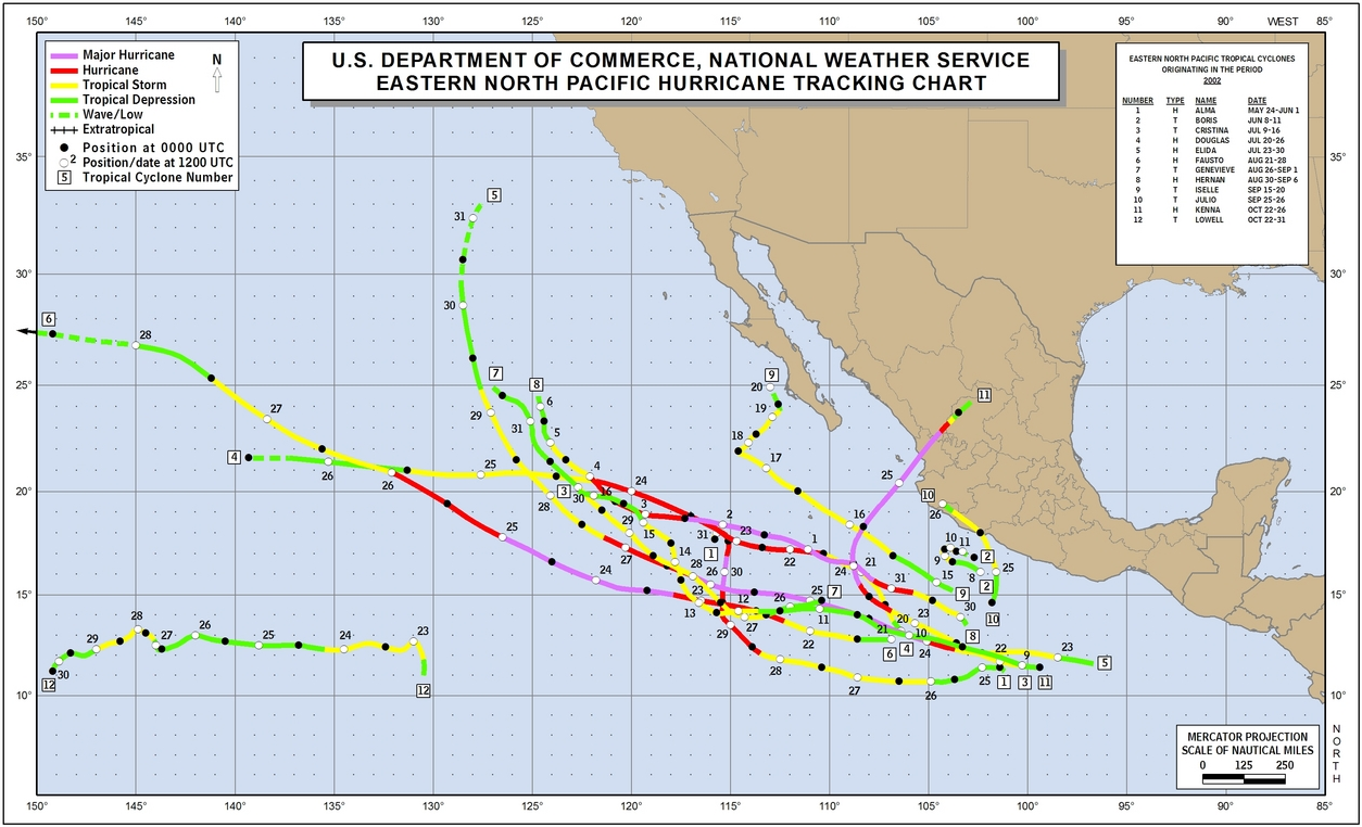


Notable storms and impacts
The most prominent storm of the year was Hurricane Kenna, which attained Category 5 intensity on the Saffir–Simpson scale before making landfall near Puerto Vallarta on October 25. Kenna struck the Pacific coast of Mexico, producing destructive winds, storm surge, and flooding; it was reported to have caused several fatalities and significant damage and is remembered as one of the most powerful hurricanes to strike that portion of Mexico's coastline.
- Tropical Storm Boris remained largely offshore but dropped torrential rains along parts of the Mexican coast, contributing to localized flooding and landslides.
- Tropical Storm Julio made landfall in Mexico and produced heavy rainfall over coastal areas and nearby inland regions.
- Hurricanes Elida and Hernan are notable for having reached very high intensity—reported at Category 5—yet they remained well offshore and did not produce significant known damage on land.
- Hurricane Fausto exhibited an unusual life cycle by weakening and later regenerating into a compact tropical storm at a relatively high latitude, a behavior that draws interest from storm researchers.
Meteorological characteristics and development
Storms in the eastern North Pacific typically develop from disturbances such as tropical waves, low-pressure systems, or remnants of other weather systems. Environmental factors that influence their formation and intensity include sea surface temperatures, atmospheric moisture, and vertical wind shear. The Saffir–Simpson Hurricane Wind Scale is commonly used to classify hurricanes in the basin by sustained wind speed, with Category 3 and higher often described as "major hurricanes." A small number of 2002 storms reached the highest intensity categories, demonstrating that the basin can produce powerful, well-organized hurricanes even when few or none make landfall.
Historical context and records
While several seasons have produced multiple intense hurricanes, years with more than one Category 5 event in the eastern Pacific are relatively uncommon and thus attract attention from meteorologists and climatologists. The 2002 season is often cited in regional summaries because of the intensity of certain storms and because some of those storms impacted populated coastal areas, prompting emergency response and post-storm assessments.
Aftermath, preparedness, and lessons
Impacts from the season reinforced the importance of forecasting, timely warnings, and coastal preparedness in Mexico and nearby countries. Rapid intensification and the compact size of some storms can complicate forecasts of landfall intensity and local impacts. Post-season analyses by forecasting agencies and researchers help refine models and communicate risk to the public for future seasons.
For further reading on the most impactful systems and technical analyses, consult regional hurricane summaries and agency reports, which provide detailed storm tracks, intensity estimates, and post-storm damage assessments.
Questions and answers
Q: What was the most notable storm of the 2002 Pacific hurricane season?
A: The most notable storm of the 2002 Pacific hurricane season was Hurricane Kenna, which reached Category 5 on the Saffir-Simpson Hurricane Scale.
Q: Where did Hurricane Kenna make landfall?
A: Hurricane Kenna made landfall near Puerto Vallarta, Jalisco, Mexico.
Q: How many people were killed by Hurricane Kenna?
A: Four people were killed by Hurricane Kenna.
Q: What other storms affected Mexico during this season?
A: Tropical Storm Julio made landfall in Mexico and Tropical Storm Boris dumped torrential rain along the Mexican coast, although it remained offshore.
Q: How many hurricanes reached Category 5 intensity during this season?
A: Two hurricanes reached Category 5 intensity during this season - Hurricanes Elida and Hernan.
Q: Did any of these two Category 5 hurricanes cause damage?
A: No, neither of these two Category 5 hurricanes caused any damage.
Q: What unusual event happened with Hurricane Fausto?
A: With Hurricane Fausto, it regenerated into a tiny tropical storm at a very high latitude.
Related articles
Author
AlegsaOnline.com 2002 Pacific hurricane season: overview and notable storms Leandro Alegsa
URL: https://en.alegsaonline.com/art/112335