Zürich: Switzerland’s largest city and financial, cultural hub
Overview of Zürich — geography, history, economy, culture and notable features of Switzerland’s largest city and capital of the Canton of Zürich.
Zürich (German: Zürich; Swiss German: Züri) is the largest city in Switzerland and the administrative centre of the Canton of Zürich. The municipality counts roughly 415,000 residents, while the wider metropolitan area exceeds 1.5 million people, making it the country’s main urban region. Zürich combines a compact historic core with modern business districts, and it is widely regarded as a global financial and cultural node.
Image gallery
10 Images


Geography and transport
The city sits where the Limmat River flows out of Lake Zurich toward the north-west, giving it a distinctive waterfront and a set of linear neighbourhoods that follow the lake and river. Its central location in northern Switzerland makes Zürich a key transport hub: national rail and road networks converge here and an international airport serves both business and tourist traffic. The city’s public transport system — trams, buses and regional trains — links dense urban neighbourhoods with suburban and lakeside areas.
History and development
Human settlement in the area dates to the Roman era, when a settlement known as Turicum stood near the present centre. Over the medieval and early modern periods Zürich grew into an important trade and craft centre. In the 16th century the city was instrumental in the Protestant Reformation under leaders such as Huldrych Zwingli, and later industrialisation and the expansion of finance and commerce reshaped its economy. Today Zürich balances historic streets and church towers with 19th–21st century industry and banking institutions.
Economy, education and institutions
Zürich is a major financial centre, home to national and international banks, insurance companies and a large stock exchange. It also hosts prominent universities and research institutions that attract students and scientists worldwide, contributing to strengths in technology, life sciences and engineering. The city’s mix of corporate headquarters, startups and academic research creates a diverse employment base and a high standard of living.
Culture, tourism and everyday life
Zürich offers a rich cultural scene — museums, concert halls, theaters and festivals — along with shopping streets, restaurants and lakeside recreation. The compact Old Town contains medieval alleyways and landmarks, while modern districts feature galleries, design studios and nightlife. Public parks and the lake draw both residents and visitors during warm months for swimming, boating and promenades.
Notable facts and distinctions
- Zürich is the capital city of its canton and the most populous Swiss municipality; see municipal details here and broader city information here.
- The metropolitan area is a regional economic engine and transit node; regional statistics are often published for the metropolitan area.
- Higher education and research institutions in the city contribute to innovation and an international student community.


City name and pronunciation
The name Zürich is pronounced Zürich [ˈt͡sʏrɪç] in Swiss High German, consequently with a short ü. In German, the name Zürich is pronounced [ˈt͡syːʁɪç], i.e. with a long ü. The pronunciation of Zürich in German is Züri [ˈt͡sʏrɪ], with a short ü, and the phonetic-legal loss of the final ch. In the fourth national language of Switzerland, Rhaeto-Romanic, the city name is, depending on the dialect![]() , ,
, , ![]() [tuˈritɕ] or
[tuˈritɕ] or![]() . The Latin form handed down from Roman times is Turicum.
. The Latin form handed down from Roman times is Turicum.
The place name is first attested on the tombstone of Lucius Aelius Urbicus from the time 185-200 AD as sta Turicen, which is to be read as stationis Turicensis. The German pronunciation is first recorded around 700, when the geographer of Ravenna names the place Ziurichi in his "Cosmographia"; the spelling "iu" here probably denotes the i umlaut and thus the pronunciation ü.
There are various assumptions about the original meaning of the name.
- One explanation derives Zurich from the personal name Tūros, which is extended by the suffix -īcon, with which the place name meant "belonging to Tūros" in the sense of "settlement of Tūros". Regarding the language of the personal name, the older research thought of Venetian or Illyrian, whereas today it is interpreted as Celtic.
- An explanation by Wulf Müller, published in 2011, rejects the phenultima stress of the Latin place name Turicum (i.e. the stress on the i), applies first stress (i.e. on the u) and postulates on this basis a derivation from a river name *Turos, which is supposed to have been the name of a former Sihl arm.
- According to a thesis published in 2019 by Theo Vennemann, the place name Zurich is supposed to be related to the place names on Dürr-, Dürk-, Türk-, which are frequent in the Central European area, and for which he postulates a common Vasconic origin. The base *turi is still found today in Basque in the form iturri, where it means source, and the frequent "ending" on /k/ is interpreted as genitivus locativus, in modern Basque ko; Zurich therefore means "at the source".
Alluding to the geographical and historical circumstances, Zurich is informally referred to as the "Limmatstadt" or the "Zwinglistadt". With reference to the work of the Zurich Enlightenment thinkers in the 18th century, including Johann Jakob Bodmer, Johann Jakob Breitinger and Johann Caspar Lavater, and to the Swiss National Exhibition of 1883, the name "Limmat-Athens" is also used.
Geography
Zurich lies at 408 m above sea level at the lower (northern) end of Lake Zurich in the valley of the Limmat and the lower valley of the Sihl, nestled between the heights of Uetliberg to the west and Zürichberg to the east. The Limmat rises from the lake, while the Sihl, which flows west of the lake, joins the Limmat north of Zurich's old town at Platzspitz. The old town extends on both sides of the Limmat, which first flows northward and then gradually turns westward in an arc. The former city did not reach as far as the Sihl, but had as its western boundary the Schanzengraben, which was constructed in the 17th and 18th centuries. At that time, part of the water was diverted from the lake and led back to the Limmat in a ditch outside the bastions and bulwarks.
Topography
The municipal area of the city of Zurich occupies an area of 91.88 km², of which 4.1 km² are accounted for by Lake Zurich. It comprises the upper part of the Limmattal nature and settlement area, a section of the northern Swiss Mittelland. The canalized and partly straightened Limmat does not flow approximately in the middle of the valley, but always along the right (northeastern) edge of the valley. At 392 m above sea level, the lowest point of the municipality is reached on the Limmat near Oberengstringen.
On its western side, the Limmat valley is flanked by the wooded heights of the Albis chain, the Uetliberg and the Buechhoger, on which the western municipal boundary runs. The Uetliberg, the town's local mountain, is the highest point in the vicinity at 870 meters above sea level. Its summit can be easily reached by the Uetliberg cable car. From the platform of the Uetliberg lookout tower, there is an impressive panorama of the city and the lake and, on a clear day, as far as the Alps. To the south, the municipal ground extends into the lower Sihl Valley.
A chain of hills adjoins the Limmat Valley to the northeast, marking the watershed between the Limmat and Glatt rivers. From northwest to southeast, the height of the mostly forest-covered hilltops increases: Hönggerberg (541 m above sea level ), Käferberg (with Waidberg, 571 m above sea level ), Zürichberg (676 m above sea level ) and Adlisberg (701 m above sea level ). Between the Käferberg and the Zürichberg there is an important transition from the Limmat to the Glatt valley with the completely built-over saddle of the Milchbucks (about 470 m above sea level).
The northernmost part of the municipality extends into the plain of the Glatt valley and into the depression that connects the Glatt valley and the Furt valley. Also a part of the Katzensee (nature reserve) as well as the Büsisee, both drained by the Katzenbach to the Glatt, belong to the municipal area.
Geology
In geological terms, Zurich lies in the Molasse Basin of the Swiss Plateau. The basin was filled in the course of the Tertiary with the erosion debris of the developing Alps, whereby the sediments can be divided into different layers. Deposits under marine conditions are called marine molasse, those under fluviatile conditions freshwater molasse.
Of importance for the Zurich area is the Upper Freshwater Molasse, which was deposited between 16 and 5 million years ago. It is composed of an alternating bedding of hard sandstone beds and soft marl layers and outcrops particularly on the Uetliberg and on the hills east of the city. By means of deep drilling, a layer of molasse deposits more than 1000 m thick would be found in the subsoil of Zurich before encountering the sediments of the Jurassic period.
The decisive landscape imprint on the region of Zurich was given by the advance of the Rhine-Linth glacier during the various ice ages. The glacier deepened and widened already existing valley depressions and created new valleys. The Limmat Valley and the Glatt Valley are filled with gravels of the glacial age as well as with further sediments of the post-glacial period. Still most visible are the traces of the Würm glaciation. During the so-called stage of Zurich (about 20,000 years ago) the moraine wall was formed, which closes Lake Zurich to the north. It is marked by the ridge of high ground between the lake and the Sihl valley, by the high ground near the Lindenhof in the old town and by the Burghölzli, while the Sihl valley absorbed the flow of meltwater at the edge of the glacier.
Climate
Zurich is located in the temperate climate zone. Zurich's climate is characterized on the one hand by winds from westerly directions, which often bring precipitation, and on the other hand by the bise (easterly or northeasterly wind), which is usually associated with high-pressure situations and brings cooler weather phases than would be expected on average in all seasons. The Föhn, which is important in the Alpine valleys and at the edge of the Alps, does not normally have any special climatic effects on Zurich.
The annual mean temperature at the measuring station of the Federal Office of Meteorology and Climatology (MeteoSwiss) in Zurich-Affoltern at 444 m above sea level is 9.4 °C, with the coldest monthly mean temperatures in January at 0.3 °C and the warmest monthly mean temperatures in July at 18.8 °C. On average, about 92 frost days and 21 ice days can be expected. Summer days average around 46 per year, while 8.5 heat days are normally recorded. The Zurich-Affoltern measuring station has an average of 1531 hours of sunshine per year. The 1054 mm of precipitation are distributed over the whole year, whereby higher amounts are measured in the summer half-year and especially during the three summer months due to convective precipitation than in winter.
| Zurich-Affoltern 1981-2010 | ||||||||||||||||||||||||||||||||||||||||||||||||
| Climate diagram | ||||||||||||||||||||||||||||||||||||||||||||||||
| ||||||||||||||||||||||||||||||||||||||||||||||||
| Monthly average temperatures and precipitation for Zurich-Affoltern 1981-2010
Source: Federal Office of Meteorology and Climatology (MeteoSwiss) | |||||||||||||||||||||||||||||||||||||||||||||||||||||||||||||||||||||||||||||||||||||||||||||||||||||||||||||||||||||||||||||||||||||||||||||||||||||||||||||||||||||||||||||||||||||||||||||||||||||||||||||||||||||||||||||||||||||||||||||||||||||||||||||||||||||||||||
City area
The Limmattal is almost completely overbuilt (residential and industrial areas, commercial zones). Also densely built-up are the sun-exposed and preferred residential areas on Zürichberg and Waidberg as well as the lower slopes on the western side of the valley on Uetliberg. Over the Milchbuck, development extends into the Glattal and adjacent areas.
The city's green lungs include the extensive wooded areas of Adlisberg, Zürichberg, Käferberg, Hönggerberg and Uetliberg. Significant green spaces are also located along the lakeshore (Zürichhorn and Enge). Furthermore, the built-up area is broken up by parks and gardens. Larger contiguous agricultural areas are located in the area of Affoltern and Seebach.
Of the total area of the city of Zurich (excluding the lake portion), 45.4 % was attributed to settlements, industry and commerce, 15.5 % to traffic, 26.5 % to forests, 11 % to agriculture and 1.2 % to bodies of water in the 1996 survey. Of the area designated as a building zone, around 93 % was built over in 2004.
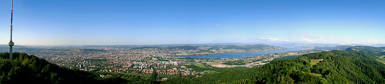
enlarge and show information about the image
![]()
View from Uetliberg to the city of Zurich
City breakdown
→ Main article: Districts of the city of Zurich
The original municipality of Zurich (before 1893) comprised only the area of today's old town. With two large city expansions in 1893 and 1934, numerous surrounding villages were incorporated, which had grown together more and more in the course of the 19th century. Today, the city of Zurich is made up of twelve city districts, numbered from 1 to 12, each comprising one to four city quarters, or two to four statistical quarters. In the city of Zurich, there are two different definitions of quarters: "city quarters" and "statistical quarters". The city quarters are historical quarters with their own coat of arms, which used to be separate villages or areas and were incorporated in the course of history. There are 22 so-called city quarters. For statistical purposes, city quarters, which are congruent with city districts, have been subdivided into further statistical quarters. For example, the Old Town, the Industrial Quarter or Aussersihl. From a statistical point of view, the city of Zurich consists of 34 quarters. The following shows the division into city quarters:
- District 1, includes the old town and thus the original municipality of Zurich (until 1893)
- District 2 on the western shore of Lake Zurich, includes Enge, Wollishofen and Leimbach (incorporated in 1893)
- District 3 in the Limmat valley between Sihl and Uetliberg, includes Wiedikon (incorporated in 1893)
- District 4 in the valley between Sihl, railroad tracks and Wiedikon, includes part of the former municipality of Aussersihl (incorporated in 1893)
- District 5 in the valley between the Limmat, Sihl and railroad tracks, includes the industrial quarter that was part of the former municipality of Aussersihl and was incorporated in 1893
- District 6 on the slope of the Zürichberg, includes Oberstrass and Unterstrass (incorporated in 1893)
- District 7 on the slopes of Zürichberg and Adlisberg, includes Fluntern, Hottingen and Hirslanden (incorporated in 1893) and Witikon (incorporated last in 1934)
- District 8 on the eastern shore of Lake Zurich, includes Riesbach (incorporated in 1893)
- District 9 between the Limmat in the north and Buechhoger and Uetliberg in the south, includes Altstetten and Albisrieden (incorporated in 1934)
- District 10 on the right bank of the Limmat on the southern slopes of Hönggerberg and Käferberg, includes Wipkingen (incorporated in 1893) and Höngg (incorporated in 1934)
- District 11 in the plain north of Hönggerberg and Käferberg between Glattal and Katzensee, includes Affoltern, Oerlikon and Seebach (incorporated in 1934)
- District 12 in the Glattal at the northern foot of the Zürichberg, includes Schwamendingen (incorporated in 1934)
As a rule, the boundaries of the city districts are congruent with the municipal boundaries that existed before 1893. However, depending on the respective size, either several municipalities were combined into one district or, in the case of Aussersihl, one municipality was divided into two districts. Furthermore, there were several major and minor boundary adjustments over the course of time.
Neighboring communities
The following municipalities border the city of Zurich: Regensdorf, Rümlang, Opfikon and Wallisellen to the north, Dübendorf, Fällanden and Maur to the east, Zollikon, Kilchberg (ZH) and Adliswil to the south, and Stallikon, Uitikon, Schlieren and Oberengstringen to the west. Urdorf borders the city of Zurich at only one point.

Related articles
Author
AlegsaOnline.com Zürich: Switzerland’s largest city and financial, cultural hub Leandro Alegsa
URL: https://en.alegsaonline.com/art/110778
Sources
- bfs.admin.ch : "Arealstatistik Standard - Gemeinden nach 4 Hauptbereichen"
- bfs.admin.ch : "Ständige Wohnbevölkerung nach Staatsangehörigkeitskategorie Geschlecht und Gemeinde; Provisorische Jahresergebnisse; 2018"
- myswitzerland.com : "Zürich entry at the Swiss Tourist Board"