Zugspitze — Germany’s Highest Peak: geography, access, and tourism
Zugspitze, at 2,962 m, is Germany’s highest mountain. This article outlines its geography, geology, glacial features, routes, transport links, recreation and conservation.
Overview
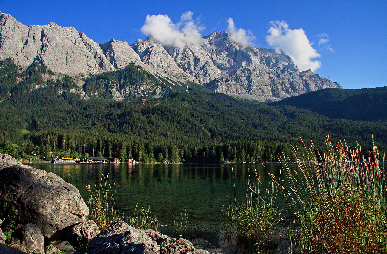
The Zugspitze is the highest mountain in Germany, rising to 2,962 m (about 9,718 ft) above sea level. It stands on the border between the German state of Bavaria and the Austrian state of Tyrol, and forms a prominent summit of the Wetterstein range. In local Bavarian dialect the name is sometimes given as Zugspitz. The summit and its surroundings are a well known landmark in the Northern Limestone Alps and draw many hikers, skiers and sightseers throughout the year.
Image gallery
10 Images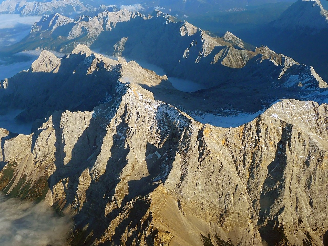


Geography and geology
The mountain is formed largely from Wetterstein limestone, producing steep faces, rocky ridges and distinct cirques. The northern slopes historically held perennial snow and small glacier remnants; these ice features have reduced in recent decades because of climatic shifts. From the summit there are extensive panoramic views across the Bavarian Alps and into neighbouring Austria and Switzerland on clear days.
Glaciers, climate and environment
Small glaciers and perennial snowfields once covered parts of the Zugspitze massif; some of these survive only as shrinking glacier remnants. The high-alpine climate brings rapid weather changes, strong winds and pronounced seasonal differences. Vegetation zones are typical of high mountains, with alpine grasses and sparse shrubs near the summit and richer forests on the lower slopes.
Access, routes and facilities
Access to the summit is possible by several mechanical and on-foot means. Mechanical options include the Bavarian rack railway and cogwheel services that reach higher stations, and a number of cable cars connecting valley towns and lakes to upper stations. From the Bavarian side a visitor can use rail and cable links that shorten the climb; from the Austrian side cable cars and alpine lifts provide alternative approaches. Marked hiking trails and via ferrata routes lead to the summit for experienced walkers and climbers. The summit area contains visitor facilities, restaurants and weather stations that operate seasonally.
History and human use
Local travel across the massif and early ascents have long been part of regional life, and documented exploration increased with the rise of alpine tourism in the 19th century. Over time engineers built mountain huts, lift systems and railway links to support access while balancing safety and conservation. The summit cross and other cultural features reflect the mountain’s long significance for local communities and visitors.
Recreation, safety and conservation
- Recreation includes hiking, mountaineering, skiing and sightseeing from summit platforms.
- Skiing is practised on high basins where snow conditions are often reliable, but seasons vary with climate.
- Visitors should prepare for rapid weather changes, bring appropriate clothing and follow local safety advice.
- Parts of the massif are subject to conservation measures; land managers aim to protect fragile alpine habitats while accommodating tourism.
As Germany’s highest point, the Zugspitze combines geological interest, a role in alpine recreation, and scientific monitoring. It remains a popular destination for those seeking both challenging climbs and accessible mountain experiences.
For localized names, regional information and visitor services see the relevant local resources and transport providers linked above.
Geography
Location and surroundings
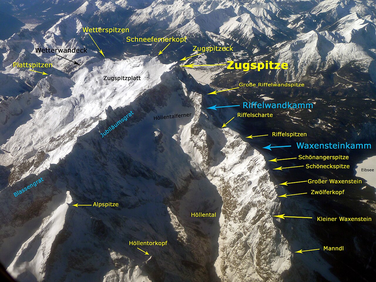
The Zugspitze is with a height of 2962 meters (east peak) the highest mountain of the Zugspitze massif. This value according to the Amsterdam gauge is given as the official height by the State Office for Digitalization, Broadband and Surveying. According to the Trieste gauge used in Austria, which is 27 cm lower, the same height is given. Originally, the Zugspitze had three summits: east, middle and west. The east summit, which lies entirely in Germany, is the only one to have survived in its original form. The middle summit fell victim to a cable car summit station in 1930. In 1938, the west summit was blown up to gain building space for a planned Wehrmacht air control station. However, this was never built. Originally, the height of the west summit had been 2964 m.
The Zugspitze rises eleven kilometres southwest of Garmisch-Partenkirchen and just under six kilometres east of Ehrwald. The border between Germany and Austria runs across the western summit. Thus, the Zugspitze massif belongs to the German state of Bavaria and the Austrian Tyrol. The governing municipalities are Grainau and Garmisch-Partenkirchen on the Bavarian side, and Ehrwald on the Tyrolean side. To the west the Zugspitze massif drops into the valley of the Loisach, which flows around the massif to the northeast in an arc, while to the east the rivers Hammersbach and Partnach rise. To the south, the Gaistal with the Leutascher Ache separates the Wetterstein mountains from the Mieminger chain. In the north is the Eibsee at the foot of the Zugspitze. The next highest mountain in the area is the Zwölferkogel (2988 m) in the Stubai Alps, so the dominance value for the Zugspitze is 25.8 km. The reference point for the Schartenhöhe is the Parseierspitze (3036 m). In order to climb it from the Zugspitze, one has to descend to the Fernpass (1216 m), resulting in a Scharten height of 1746 m.
Zugspitze Massif
The massif of the Zugspitze includes other peaks. To the south, the Zugspitzplatt is framed in an arc by the Zugspitzeck (2820 m) and Schneefernerkopf (2874 m), the Wetterspitzen (2747 m), the Wetterwandeck (2698 m), the Plattspitzen (2679 m) and the Gatterlköpfe (2490 m). The massif ends with the Gatterl (2024 m), a saddle towards the Hochwanner. From the Zugspitze to the east, the Jubiläumsgrat runs in the direction of the Alpspitze and Hochblassen over the Höllentalspitzen. In northeastern direction the short Riffelwand ridge goes over the Riffelwandspitzen (2626 m) and the Riffelköpfe (2459 m), to the Riffelscharte (2161 m). From here the Waxenstein ridge runs over the Riffelspitzen to the Waxenstein.
Zugspitzplatt
The Platt (also Zugspitzplatt) is a plateau below the Zugspitz peak in a southerly and southeasterly direction at an altitude of between 2000 and 2650 metres. It forms the end of the Reintal and was formed by weathering, karstification and glacial overprinting. The area contains round humps, sinkholes, cirques or scree as a result of the glacial periods. Moraines have also remained from various cold periods. At the beginning of the 19th century, the Platt was completely glaciated for the last time. Today, it consists of 52% debris, 32% bedrock and 16%, especially in the middle and lower parts, of soils with vegetation.
![]()
enlarge and show information about the picture
![]()
Panoramic view from the observation deck at Zugspitzplatt in southeast direction to the Zillertaler Alps in winter time.
Natural classification
The Zugspitze belongs to the natural unit group Northern Calcareous Eastern Alps (No. 93; part of the Northern Calcareous Alps), to the natural unit Inntaler Riffkalkketten (933) and to the natural unit Wettersteinketten (933.04) in the subunit Wetterstein Mountains (933.0).
Adjacent natural areas in a clockwise direction are: The landscape slopes northeast into the Höllental (933.01) natural area, through which the Hammersbach flows, and east into the Reintal (933.02) natural area, through which the Partnach flows. To the south it leads to the Wetterspitzen, from where it descends into the part of Obere Leutasch (930.320) belonging to the natural area Leutasch (930.32). To the southwest to the west it drops directly into the Ehrwalder Becken (Lermooser Becken; 930.22) natural area, which belongs to the Fernpaß-Loisachtaler Becken und Talböden (930.2) subunit in the main unit Basin and Valley Floor between the main groups of the Northern Limestone Eastern Alps (930). To the northwest, the landscape slopes down into the Northwestern Wetterstein Shelf (Törlenplatte; 933.00) natural area located at Hoher Egg and Pollerköpfe. To the north it slopes down to the Eibseeplatte (930.250) located at the Eibsee lake and to the northeast, among others, over the Waxenstein to the Südliches Werdenfelser Mittelgebirge (930.251), both of which are parts of the Werdenfelser Mittelgebirge (930.25) nature area.
Climate
Climatically, the Zugspitze lies in the temperate climate zone and in the area of the westerly wind zone. As the first high orographic obstacle of these westerly winds in the Alps, the Zugspitze is particularly exposed to weather events. It comes to the "northern congestion of the Alps", which dams up the humid air masses and causes intense precipitation. On the other hand, the Zugspitze also has a shielding function for more southerly parts of the Alps. The Föhn weather situation, which occurs 60 days a year in the region, counteracts the northern congestion. Dry and warm air masses flow from south to north. They can provide exceptionally high temperatures in winter. However, there is still frost on the Zugspitze on an average of 310 days.
For the normal period between 1961 and 1990 the annual average precipitation on the Zugspitze was 2003.1 mm, the month with the highest precipitation was April with 199 mm, the month with the lowest precipitation was October with 108.8 mm. The average temperature in this normal period was -4.8 degrees Celsius, with July and August being the warmest with 2.2 °C and February the coldest with -11.4 °C. The sun shone on average during this period. On average, the sun shone for 1846.3 hours a year during the normal period, with October having the most sunshine (188.8 hours) and December the least (116.1 hours). In 2009, according to the weather balance of the German Weather Service, the Zugspitze was the coldest place in Germany with an annual average of -4.2 °C.
The lowest temperature measured on the Zugspitze was -35.6 °C on 14 February 1940. July 5, 1957 brought the highest; its value was 17.9 °C. A squall on 12 June 1985 brought the highest wind speed measured on the Zugspitze, 335 km/h. The highest measured snow height was 7.80 m on 26 April 1980.
| Zugspitze | ||||||||||||||||||||||||||||||||||||||||||||||||
| Climate diagram | ||||||||||||||||||||||||||||||||||||||||||||||||
| ||||||||||||||||||||||||||||||||||||||||||||||||
| Monthly average temperatures and precipitation for Zugspitze
Source: wetterkontor.de, German Weather Service | |||||||||||||||||||||||||||||||||||||||||||||||||||||||||||||||||||||||||||||||||||||||||||||||||||||||||||||||||||||||||||||||||||||||||||||||||||||||||||||||||||||||||||||||||||||||||||||||||||||||||||||||||||||||||||||||||||||||||||||||||||||||||||||||||||||||||||
Geology
All mountain-forming layers consist of Mesozoic sediments that were originally deposited on the sea floor. The base of the mountain consists of shell limestone layers, the upper area is formed by Wetterstein limestone. With steep faces up to 800 m high, predominantly Wetterstein limestone from the upper Triassic forms the walls, ridges, towers and summit rock of the mountain. Due to the frequent occurrence of marine calcareous algae in the Wetterstein limestone, it can be assumed that this rock was once formed in a lagoon. The color of the rock varies from grayish white and light gray to mottled. Lead and zinc ores are present in several places. These mineral resources were extracted by mining in the Höllental between 1827 and 1918. The dark grey, almost horizontal and partly grass-covered layers of the Muschelkalk extend from the foot of the Große Riffelwandspitze to the Ehrwalder Köpfe. Looking at the north face of the Zugspitze, you can see that the mountain massif originally consisted of two mountains that were pushed on top of each other.
During a prehistoric landslide around 3750 years ago, around 200 million cubic metres of rock from the Bavarian Schneekar broke away towards the Eibsee floor. The rock masses deposited in the valley floor in the process contain significantly more material than appears to be missing from the eruption site. Geologists therefore suspect that an original, higher summit structure also descended during the event. Therefore, the Zugspitze could still have been a three-thousand-metre peak in geologically recent times.
Glacier
Three of the five German glaciers are located in the Zugspitze massif, in addition to the Höllentalferner, the Southern and Northern Schneeferner.
Höllentalferner
The Höllentalferner lies northeast of the Zugspitze in a cirque below the Jubiläumsgrat to the south and the Riffelwandspitzen to the west and north. It is exposed to the northeast. The nourishing area is formed by a hollow where large amounts of avalanche snow accumulate. Towards the south, the Jubiläumsgrat shields the glacier well from sunlight. These circumstances meant that the glacier lost relatively little area between 1981 and 2006. The Höllentalferner reached its modern peak around 1820 with a size of 47 ha. After that, it continuously lost area until it increased again by 3.1 ha to 30.2 ha between 1950 and 1981. Since then, the glacier lost an area of 5.5 ha by 2006 and was only 24.7 ha in size. Its highest point in 2006 was at 2569 and its lowest at 2203 m.
Schneeferner
North Snow Glacier
Southwest of the Zugspitze, between Zugspitzeck and Schneefernerkopf, is the Nördlicher Schneeferner, which is exposed to the east. It is the largest German glacier with an area of 27.9 ha (2013), but at the end of the 19th century it still covered 103 ha. Around 1820, the entire Zugspitzplatt was glaciated, and only the Nördlicher and Südlicher Schneeferner remain of this flat glacier. The reason for the relatively constant surface development of the northern Schneeferner in recent years, despite the lack of shade, is the favourable terrain. This leads to the glacier losing or gaining thickness rather than area. In the recent past, moreover, the glacier has been artificially nourished by ski area operators by pushing large amounts of snow onto the glacier with snowcats to extend the ski season. In 1993, work also began on covering the Nördlicher Schneeferner with plastic sheets in the summer to protect it from the sun's rays. However, this venture was abandoned by the Bayerische Zugspitzbahn in 2013. The Nördlicher Schneeferner had its last peak in 1979, when it measured 40.9 ha. By 2006, its area had decreased to 30.7 ha. The highest point was at 2789 m and the lowest at 2558 m. By 2013, it had shrunk further to 27.9 ha.
Southern Snow Glacier
The Southern Schneeferner is framed by the Wetterspitzen and the Wetterwandeck. It is also a remnant of the large Plattgletscher. It is disputed whether the Südlicher Schneeferner can still be classified as a glacier. The Southern Schneeferner also had its last peak in 1979, when it covered an area of 31.7 ha. However, it declined to 3.4 ha by 2015. At that time, the highest point of the glacier was at 2641 m and the lowest at 2557 m.
Permafrost
The decline of permafrost is a worldwide problem. The Zugspitze is not exempt from this either. There is an old supply tunnel on the Zugspitze. 30 years ago, the tunnel was completely iced over. However, a team of researchers from the University of Bonn found that not much of the meter-thick ice layers are left. Measurements using sound waves and electrical conductivity led scientists to the same conclusion: There is only a little permafrost left in the rock of the Zugspitze.
The rock of such mighty mountains is held together by the ice in the crevices and fissures. If this melts, parts of it can break off. It is believed that a landslide occurred on the Zugspitze 3700 years ago for this reason.
An early warning system was therefore installed in August 2007. For this purpose, a 60-metre-long tunnel with a diameter of 12 centimetres was built on the summit of the Zugspitze in a north-south direction. This is intended to provide regular information on how much ice is present in the summit area.
Caves
Below the Zugspitz plateau, chemical weathering processes in the Wetterstein limestone have created a large number of caves and shafts. In the 1930s the number of caves was estimated at 300; the first explorations in them took place in 1931. 62 caves were known by 1955, and 47 more were discovered by 1960. Major explorations took place in 1935, 1936, and between 1955 and 1968. During an expedition in 1958, the Finkenschacht was discovered, the deepest cave on the Zugspitze to date. It is 131 m deep, 260 m long and meets a watercourse.


Nature
Flora
The flora is not particularly varied due to the soil conditions, but the flora is particularly colourful at the Schachen, at the Tieferen Wies near Ehrwald, in the Höllen, Gais and Leutasch valleys.
The shady and humid north of the massif, such as the Wetterstein forest, is one of the most species-rich areas of the Zugspitze. The mountain pine reaches heights of over 1800 m. The forests below consist mainly of spruce and fir, but honeysuckle, woodruff, mountain ash, meadow rue and speedwell also occur here. In less overgrown areas, black columbine, alpine vine, monkshood, yellow monkshood, weather thistle, alpine meadowsweet, golden cinquefoil, round-leaved saxifrage, wall hawkweed, mountain mint and alpine forget-me-not bloom. On the rocky soils of the mountain forest thrive cinquefoil, sticky sage, plaguewort, alpine rose, Turk's-bunch, orchid, fly agaric; especially in the Höllental, in Grainau and at the Eibsee the lily of the valley and the daphne.
Towards the south, the picture changes to larch (mainly at the Ehrwalder Alm, in the Gais and Leutasch valleys) and pine forests and to a mixed forest of beech and sycamore maple. Mountain pines also grow there at higher altitudes up to over 2000 metres.
Lime, birch, rowan, juniper and yew are relatively rare throughout the Zugspitze region. The most diverse species of mosses, which often completely overgrow exposed limestone rocks in the forests, on the other hand, occur in great numbers.
Limited to dry places are blueberry, cranberry and cranberry. In sheltered places there is lady's slipper. Below the Waxensteine there are fields with raspberries and occasionally wild strawberries. The alpine poppy and the saxifrage thrive up to a fairly high altitude. In the scree slopes you can find helleborine and hornwort as well as white silverwort, alpine cinquefoil and musk saxifrage. After the melting of the snow, dark stonecrop and snow gentian are the first to sprout, their seeds beginning to germinate as early as autumn. The well-known alpine flowers edelweiss, gentian and rarely the cyclamen also bloom on the Zugspitze.
Fauna
The rocks around the Zugspitze are the habitat of the chamois. On the south side of the massif the marmot is common. At the Zugspitze summit, the alpine chough is mainly found, attracted by feeding humans. A little lower is the range of the snow hare and the dormouse. Occurring alpine birds are also golden eagle, rock ptarmigan, snow sparrow, alpine fluebill and mountain finch. The rock swallow, to which the swallow wall at the Kreuzeck owes its name, is also frequently encountered. The Mittenwald and Seefeld valleys, as well as the Fernpass, are bird migration routes.
Rocky terrain is home to the mountain lizard and the black alpine salamander, also known as the "Bergmandl", which can usually be seen on mountain climbs after a rain shower. On the west and south side of the Zugspitze massif, butterflies such as the Apollo butterfly, alpine mother-of-pearl, blue butterfly, peeper butterfly, moor butterfly and thick-headed butterfly can be seen, especially in July and August. The forests around the Zugspitze are home to red deer, squirrels, weasels, capercaillie, hazel and black grouse. Glacier fleas and tardigrades live on the glaciers.
Protected areas
Parts of the Wettersteingebiet landscape conservation area including the mountain pine belt near Mittenwald (CDDA No. 395756; designated in 1976; 85.8919 km² in size) extend up to the summit of the Zugspitze. Parts of the fauna-flora-habitat area Wettersteingebirge (FFH no. 8532-371; 42.5691 km²) extend up to the summit region and those of the nature reserve Schachen und Reintal (CDDA no. 20723; 1970; 39.6502 km²) and the bird sanctuary Schachen und Reintal (VSG no. 8532-471; 39.6564 km²) extend only up to the Innere Höllentalspitze.


Related articles
Author
AlegsaOnline.com Zugspitze — Germany’s Highest Peak: geography, access, and tourism Leandro Alegsa
URL: https://en.alegsaonline.com/art/110750
Sources
- commons.wikimedia.org : Zugspitze