Zambezi
![]()
The title of this article is ambiguous. For other meanings, see Zambezi (disambiguation).
The Zambezi (also Zambezi or Zambezi) is the fourth longest river in Africa after the Nile, Congo and Niger, with a flow length of 2574 km, and the largest African river flowing into the Indian Ocean. The catchment area covers areas in eight states in southern Africa and covers about 1.33 million square kilometres (km²), which is about half that of the Nile. This makes it the fourth largest river system in Africa. It is best known worldwide for the Victoria Falls. It is located in southern Africa.
The source of the Zambezi River is located in the Zambezi Source National Forest and is situated on the Lunda River in Zambia, on the border between the Democratic Republic of Congo and Angola. It flows through Angola, Zambia and Mozambique, where it empties into the Strait of Mozambique in an 880 km² delta. It also partially forms the border of Zambia and Namibia, as well as Zambia and Zimbabwe, where it forms Africa's most powerful waterfall, Victoria Falls, at the level of the towns of Livingstone (Zambia) and Victoria Falls, where it falls some 110 metres. Other waterfalls include Chavuma Falls on the border between Zambia and Angola and Ngonye Falls, located near Sioma in western Zambia. The river is spanned over its entire length by only eleven bridges (see below: importance as a transport route).
The hydropower plants of the Cahora Bassa dam supply South Africa with electricity via a 1420-kilometre-long direct current transmission line, the HVDC Cahora Bassa. The Zambezi River is navigable in its lower reaches from Tete. Hippos are still found in the Zambezi today.
History
Source
The Zambezi River rises in a swampy rainforest area of the Mitumba Mountains in northwestern Zambia at an altitude of about 1500 m, on the border with the Democratic Republic of Congo. The headwaters are thus north of Mwinilunga at Kalene Hill in the Zambian tip between Angola and the DR Congo. East of its source is the watershed between the Zambezi and Congo River basins (Lualaba), which runs as a range of hills almost from east to west. To the south drains the river basin of the Western Lunga.
The Zambezi runs first a few kilometres to the north, then to the west, and reaches the territory of Angola after almost 100 river kilometres, about 90 km west of Kalene Hill.
Upper reaches
After the Zambezi flows about 240 kilometres in a south-westerly direction, it bends to the south and enlarges through numerous tributaries. A few kilometres above Kakengi, the riverbed widens from 100 to about 350 metres. Below Kakengi, a few rapids follow, leading to Chavuma Falls, which is considered the upper limit of the approximately 600-kilometre-long headwaters, where the river drops only 180 metres in altitude. From there on, the Zambezi flows through a rocky gorge.
The first large tributary to flow in is the Kabompo River in northern Zambia, with the Lungwebungu River flowing in further south. The savannah through which the river previously ran is replaced by open bushveld, overgrown with Borassus palms. Dense vegetation is limited to a few hundred metres of narrow forest strip that cover the surrounding countryside of the Zambezi and its tributaries during the first 160 kilometres of the river.
The following downhill stretch runs for about 350 kilometres from 1050 metres above sea level at Chavuma Falls to 1000 metres above sea level at Kakengi. From there to the Victoria Falls, the course is even and slopes only slightly further. 30 kilometres below the confluence of the Lungwebungu, the landscape becomes very flat and floods extensively during the rainy season. Another 80 kilometres downstream, two more tributaries, the Luena and the Luanginga, which has a large catchment area in the west, flow into the river.
Just below is Lealui, one of the largest towns of the Lozi people who inhabit the semi-autonomous region of Barotseland. The Lozi leader has two branches in Lealui and Limulunga, which serves as the capital during the rainy season due to its high altitude. The annual procession from Lealui to Limulunga is a major event celebrated with one of Zambia's most famous festivals, the Kuomboka ceremony.
Below Lealui, the Zambezi turns to the southeast. Over the following 240 km of river, only tributaries flow in from the east, before the Cuando flows in again from the west. On this section are the Ngonye Falls and further rapids. South of it, the river borders the Zambezi region, which belongs to Namibia and which, under the name of Caprivi, gave the former colony of German Southwest Africa its own access to the Zambezi.
Below the junction of the Zambezi and the Cuando the stream turns exactly to the east. Here it is very broad and shallow, with a slow rate of flow. In its further course eastward the Zambezi passes into the great African central plateau, where it reaches a gorge which terminates in the Victoria Falls. There, the Zambezi falls over a 110-meter drop over a 1708-meter wide cliff.
Middle course
Victoria Falls is considered the boundary between the upper and middle reaches of the Zambezi. The course of the river to the east continues for another 200 km, cutting through vertical basalt walls up to 250 meters high. The velocity of the current is high in these gorges, occasionally interrupted by stone banks. Following these gorges is a series of rapids that end 240 kilometres below Victoria Falls. In the course of this stretch, the river drops 250 metres. Until the construction of bridges and dams, the Zambezi escarpments of the middle reaches were considered impassable.
Following this, the Zambezi flows into the Kariba Reservoir, which was created in 1959 after the construction (1955-1959) of the Kariba Dam. The lake is one of the largest man-made lakes in the world, and the dam's hydroelectric power stations provide electricity for much of Zambia and Zimbabwe. The Zambezi River Authority, as a binational authority, is responsible for the complex.
The Luangwa and the Kafue are the two largest left tributaries of the Zambezi. The Kafue joins the Zambezi as a quiet flowing and deep stream at a width of 180 meters. From this point the slightly northward deviating course of the river changes its direction again directly to the east and crosses the border to Mozambique with the tributary of the Luangwa.
The middle Zambezi ends with the Cahora-Bassa reservoir. This lake was also created by the construction of a dam (1969-1979), previously in its place were the dangerous rapids of Kebrabassa.
Underflow
The lower 640 kilometres of the Zambezi from Cahora Bassa to the Indian Ocean are navigable, with the river being very shallow in many places during the dry season. This is aided by the fact that the Zambezi flows into a wide valley and splits over a large area. Only at one point, in Lupata Gorge, is the river limited by hills to a width of 200 metres. Otherwise, it stretches in many individual river channels over a width of five to eight kilometres. The river bed is sandy, the banks are low and lined with reefs. At times, the individual runs merge into a single wide, fast-flowing stream, especially in the rainy season.
About 260 kilometres from the sea, the Zambezi River receives tributary from Lake Malawi with the Shire River. Closer to the coast, it forms a wide-ranging river delta consisting of numerous branches. Each of the four main mouths, Milambe, Kongone, Luabo and Timbwe, is surrounded by sandbanks. A more northerly branch, ending in the Chinde estuary, has a depth of two to four metres and is used for navigation. 100 kilometres further north runs the Quelimane River, named after the town of the same name at its mouth. This silted river receives water from the flooded Zambezi in the rainy season. The Zambezi delta is now only half as wide as it was before the construction of the Kariba and Cahora Bassa dams, which regulate the seasonal variations in water levels.
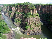
Gorge below the Victoria Falls
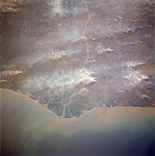
The Zambezi Delta
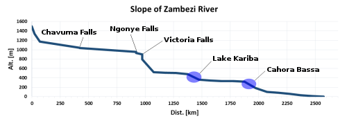
The gradient of the Zambezi shown as a graph
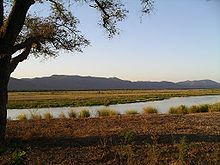
Zambezi River in Mana Pools National Park below Kariba Dam
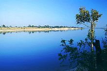
The Zambezi River in Northwestern Zambia
Catchment area
The Zambezi River basin is the fourth largest on the African continent, covering approximately 1,351,000 km². It extends over a total of eight states. Zambia has the largest share (43%), followed by Angola (17%), Zimbabwe (16%), Mozambique (12%), Malawi (8%), Tanzania (2%), Botswana (1%) and Namibia (1%). Malawi and Tanzania are not immediate Zambezi riparians, they are connected to the Zambezi via Lake Malawi and the Shire.
The catchment area of the Zambezi River is divided as follows (based on 1,351 million km²):
| States | Catchment area of the national territory in [km²]. | Percentage of the catchment area | Percentage of the country |
| Angola | 235.423 | 17,4 | 18,9 |
| Namibia | 17.426 | 1,3 | 2,1 |
| Botswana | 12.401 | 0,9 | 2,1 |
| Zimbabwe | 213.036 | 15.8 | 54,5 |
| Zambia | 574.875 | 42,5 | 76,4 |
| Tanzania | 27.840 | 2,1 | 2,9 |
| Malawi | 108.360 | 8,0 | 91,5 |
| Mozambique | 162.004 | 12,0 | 20,2 |
| Total | 1.351.365 | 100 |
The centre of the catchment is a vast plateau bounded by a rugged ridge, the remote interior of which consists of variegated beds of stone, fringed by the cliffs of Victoria Falls. At Shupanga, on the lower Zambezi, layers of grey and yellow sandstone are found in the dry season, with streaks of limestone between. These are found as far as beyond Tete, where they are accompanied by larger deposits of coal, even below Victoria Falls. Gold-bearing rocks occur in various places.
The southern part of the catchment area lies predominantly in arid regions. Therefore, the Zambezi receives most of its water from the northern tributaries. This can be observed especially in the discharge behaviour of the Cundo, whose catchment area is comparable in size to that of the Kafue, but which has only one tenth of its discharge.
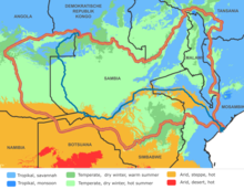
The catchment area of the Zambezi according to Köppen-Geiger climate classification.
Search within the encyclopedia