Xanten: Roman roots and medieval centre in North Rhine-Westphalia
Xanten is a historic town in North Rhine-Westphalia, Germany, famed for its Archaeological Park built on a Roman colony and for a picturesque medieval centre dominated by Xanten Cathedral.
Xanten is a small historic town in western Germany known for its unusually visible layers of history. Located near the Lower Rhine in the Wesel district, it combines a medieval market town atmosphere with a major archaeological landscape that attracts many visitors each year. The town appears in older sources under Latin names such as Xantum or Castra Vetera and today is notable for its preserved cathedral, reconstructed Roman remains and waterside recreation areas.
Image gallery
8 Images


Location and character
Administratively Xanten lies in the Wesel district of the state of North Rhine-Westphalia. Its situation near the Rhine and on low-lying plains shaped both its historic importance and its modern leisure offerings: lakes and former gravel pits near the town are used as recreational water areas. The compact city centre retains narrow streets, timber-framed facades and the tall silhouette of the cathedral that dominates the skyline.
Historical development
Xanten's long history includes a prominent Roman chapter. A Roman military camp and later a large civilian settlement stood here during the imperial period; archaeological work has uncovered streets, walls and public buildings from that era. In the medieval centuries Xanten developed as a regional market and ecclesiastical centre; the Gothic cathedral and several surviving churches testify to its religious and civic role in the Middle Ages. Over time the town was rebuilt and reshaped by warfare, trade and changing political boundaries typical of the Rhineland.
Archaeological Park and attractions
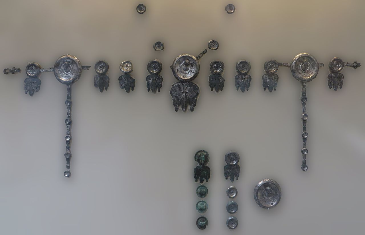
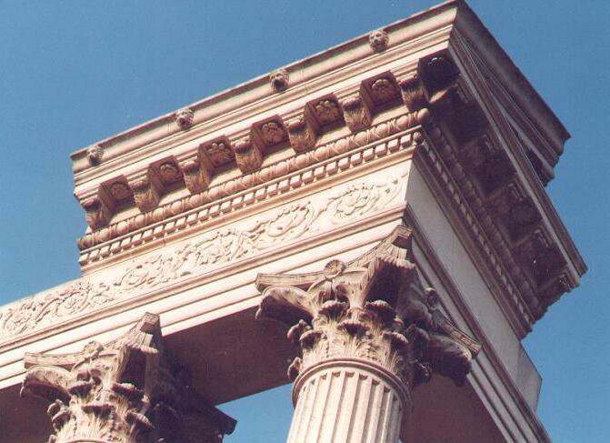
The Archaeological Park is the town's best-known attraction: it interprets the Roman city and nearby legionary fort with visible foundations, partial reconstructions and museum displays that explain everyday life in antiquity. Visitors can explore a reconstructed amphitheatre, sections of Roman walls and a museum collection of finds. In the medieval core the large Xanten Cathedral (St. Viktor) is a focal point for art, architecture and local identity.
- Main sites: Archaeological Park (Archäologischer Park Xanten), Xanten Cathedral, historic market square.
- Leisure: lakes and waterfronts used for sailing, walking and family recreation.
- Cultural notes: local festivals, guided archaeological tours and a museum programme.
Xanten is also a place of local legends and regional lore; for example it figures in medieval heroic traditions. It remains distinctive within Germany for linguistic reasons as well: Xanten is the only German town name beginning with the letter "X". Practical information and visitor resources can be found via the town's official channels and regional portals: official town information, general information about Germany, details at the state level for North Rhine-Westphalia and district resources for Wesel district.
For travellers and students of history, Xanten offers a compact way to experience both Roman urban planning and medieval ecclesiastical architecture within a small town setting. The blend of open-air archaeology, museum interpretation and a living historic centre makes it a notable destination on the Lower Rhine.
Geography
Location
Xanten is located at 51° 39′ 44″ north latitude and 6° 27′ 14″ east longitude in the Lower Rhine lowlands 35 km northwest of Duisburg.
The villages belonging to the town of Xanten are divided into the six municipal districts of Birten, Lüttingen, Marienbaum, Vynen/Obermörmter, Wardt (with Mörmter and Willich) and Xanten (with Beek and Ursel). The town of Xanten itself is further divided into the three districts of Hochbruch, Niederbruch and the actual town centre of Xanten, the town of Birten into Oberbirten and Unterbirten.
In the northeast, the city area is bordered by the Rhine. Between the Rhine and the village of Birten, the Xantener Altrhein, a meander connected to the Rhine only via the Graben Göt, separates the Bislicher Insel nature reserve from the rest of the town and forms the basis of the floodplain landscape there. Situated between Birten and Xanten, the Fürstenberg, which is partly a nature reserve, forms one of the few elevations in the otherwise mostly flat urban area. This continues over a narrow, partly wooded chain of hills via the Hees forest and the Grenzdyck nature reserve to the so-called Sonsbeck Switzerland southwest of Xanten. This range of hills, a section of the Lower Rhine range of hills, was formed as a terminal moraine during the Saale Ice Age.
Northwest of Xanten, separated from the city centre only by the city park, is the Xanten Archaeological Park, and to the north is the village of Lüttingen. Bordering the Rhine to the northeast, this lies directly on the Xantener Südsee, a lake formed by gravel excavations. It is connected to the Xantener Nordsee, which was also created by gravel excavations, via a narrow channel. The village of Wardt lies on an "island" between the Rhine on the north-eastern side and the two lakes including the canal on the south-western side, and is thus in the direct vicinity of the Xanten leisure centre. The village of Vynen lies to the northwest of the Xanten North Sea, adjacent to it. Following the course of the Rhine to the north are the village of Obermörmter and the nature reserves Gut Grindt and Rheinaue as well as Reeser Schanz. To the west of Vynen, the Uedemer Hochwald forest begins in the vicinity of the village of Marienbaum. Between Marienbaum and Xanten lie the villages of Mörmter, Ursel and Willich.
Neighboring communities
The Xanten town area is bordered by the town of Rees (Kleve district) to the north, the town of Wesel to the east, the municipalities of Alpen and Sonsbeck to the south and the towns of Uedem and Kalkar (both Kleve district) to the west.

Myths and legends
Xanten in the Saga of the Nibelungs
According to the Nibelungen saga, Siegfried of Xanten was born in the ruins of the city after the abandonment of Colonia Ulpia Traiana and ruled the Low Countries as king in Xanten.
|
19,1
19,2
19,3
19,4
| Middle High German Da wohs in nider landen a noble kuniges chint the father of the hiez Sigemvnt sin mvter Sigelint in a rich castle witen wol bechant nidene bi the Rine div was ze Santen genant | Translation (Karl Joseph Simrock) There grew in the Netherlands a noble king's child. Siegmund was his father's name the mother Siegelind. In a mighty fortress widely known, Down by the Rheine Xanten it was called. |
Hagen of Tronje was also associated with Xanten through the name of "Colonia Ulpia Traiana" and the Lower Rhine Troy myth.
Xanten in the Lower Rhine myth of Troy
→ Main article: Lower Rhine Troy myth
Based on the name of the former Colonia Ulpia Traiana, the terms Troia Minor (Little Troia) and Troia Francorum (Frankish Troia) were also established for Xanten until the Middle Ages. Around 1100, the Annolied finally told of the founding of Xanten by the defeated Troians in the Troian War:
|
389 390 391 392 393 394 395 396 | Middle High German Franko gesaz with the sînin vili verre nidir bî Rîni. dâ worhtin si duo with vroudin a luzzele Troii. the brook hîzin si Sante nâ demi wazzere in iri lante; den Rîn havitin si vure diz meri. dannin wuohsin sint Vreinkischiu heri. | Translation (Eberhard Nellmann, Reclam) Franko let himself be taken with his own far away on the Rhine. There they built at that time with joy a little Troy. They called the brook Sante after the river of their homeland. They took the Rhine instead of the sea. There the Frankish people grew since then. |
Even when Xanten fell to the Duchy of Cleves in 1444, coins with the inscription "Joannes Troianorum Rex" ("John, King of the Troians") were minted in the same year.
Christian saints
The Christian legionary Victor of Xanten is said to have been executed together with 330 other members of the Theban Legion in the amphitheatre of Vetera in the 4th century. Victor of Xanten has since been regarded as a martyr and later patron saint of St. Victor's Cathedral, which was built over his presumed burial place. Similar to the legend of Gereon of Cologne, the legend of Victor also includes the Empress Helena of Constantinople, who is said to have recovered the bones of St. Victor and his legionaries and built a chapel for them.
Saint Mallosus was one of the companions of Victor and was therefore also venerated in Xanten. From the High Middle Ages, however, Mallosus was also regarded as a saint in Bonn, where he is said to have shared the fate of Cassius and Florentius in the wake of the Theban Legion.
According to tradition, the bones of St. Gerebernus were brought to Sonsbeck by "robbers from Xanten" and founded the pilgrimage that lasted there until 1945.


Related articles
Author
AlegsaOnline.com Xanten: Roman roots and medieval centre in North Rhine-Westphalia Leandro Alegsa
URL: https://en.alegsaonline.com/art/109424