Würzburg: Franconian city on the Main with a long cultural and religious history
Würzburg is a historic city in northern Bavaria on the Main River, known for its baroque Residence, university, bishopric, wine culture and a history stretching from Celtic settlement to modern reconstruction.
Overview
Würzburg (often written Wuerzburg when the character ü is unavailable; see orthography note) is a city in northern Bavaria on the river Main. It serves as an administrative and cultural centre of Lower Franconia and is home to a large university, a Roman Catholic bishopric and a population of roughly 124,000 people. The city is an important node in regional wine production and Franconian cultural life.
Image gallery
10 Images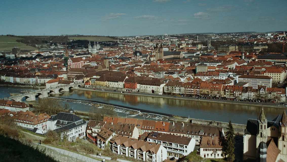


Geography and character
Situated in a loop of the Main, Würzburg combines riverfront districts, terraced vineyards on surrounding slopes and a compact historic centre. Its location in the German federal state of Bavaria places it within the Franconian cultural region rather than the Alpine south often associated with other parts of Bavaria. The local economy mixes education, public administration, healthcare, tourism and wine production; the city's white Silvaner and Müller-Thurgau wines are regionally distinctive.
Historic development
The site has been occupied since prehistoric times: archaeologists have traced a Celtic settlement in the area around 1000 BC (Celtic origins). Written records begin in the early Middle Ages: the place is first mentioned in 704 AD and was Christianised by 698 AD. In 742 Würzburg became the seat of a bishopric, and the bishops later gained princely and ducal status in the Holy Roman Empire (from 1168 onwards). A university was founded in 1402; it experienced interruptions and was refounded in the late 16th century (1582), evolving into the modern University of Würzburg with a long academic tradition.
Conflict and modern history
Würzburg's position made it a focal point in several European conflicts. It was occupied in the Thirty Years' War—briefly taken by the Swedish king Gustavus Adolphus in 1631 (Gustavus Adolphus)—and later changed hands during Napoleonic-era reorganisations; in 1803 the ecclesiastical duchy was secularised and the area was incorporated into Bavaria. The city surpassed 100,000 inhabitants around 1938. In late World War II Würzburg suffered near-total destruction in 1945 and was subsequently rebuilt, combining restored baroque monuments and 20th‑century urban planning.
Landmarks and culture
- The Würzburg Residence, a baroque palace with elaborate frescoes and a UNESCO-listed ensemble, is the city's most famous landmark.
- Fortress Marienberg commands the hillside above the river and preserves medieval and early modern fortifications.
- The cathedral (Dom) and numerous churches reflect the city's long status as a bishopric (bishopric).
- Vineyards and wine taverns (Heckenwirtschaften) on the surrounding slopes form an active local viticulture tradition.
Education, sport and contemporary life
The University of Würzburg is a major employer and research centre, with faculties spanning the humanities, natural sciences and medicine. Cultural institutions include museums, concert halls and festivals that celebrate music, science and regional Franconian traditions. The city also supports modern sport teams; its best-known football club is the Würzburger Kickers (Würzburger Kickers), which is a part of local sporting culture.
Notable facts and distinctions
Würzburg is often noted for the contrast between its baroque architectural heritage and the post-war reconstruction that restored key monuments. Tourism is driven by its UNESCO site, river cruises on the Main, wine tourism and university visitors. For practical information and detailed resources on the city's institutions, festivals and visitor services, consult local guides and official city resources (Bavaria context, regional services).


Geographical location
Würzburg is surrounded by Spessart, Rhön and Steigerwald in the so-called Maindreieck in a valley basin in the middle Maintal. The Main, the most important watercourse in the region, flows through the western part of the city. Its hillside location, climatic conditions and other locational factors make Würzburg a renowned wine-growing region. Three of the fifteen largest German wineries are located in Würzburg. Due to its convenient location, Würzburg is a popular meeting place for many events. By train, you can reach Berlin in almost four hours and Frankfurt am Main is 120 kilometers away.
On the hill of a shell limestone plateau, the Marienberg, stands one of Würzburg's famous landmarks, the Marienberg Fortress. On the neighboring Nikolausberg, near the Frankenwarte, is the highest point of Würzburg with 360 m above sea level. The lowest points of Würzburg are at 166 m at the Alter Kranen and at the Neuer Hafen.
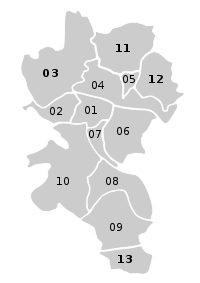
City breakdown
| No. | Borough | Population |
| 01 | Old Town | 18.768 |
| 06 | Women's Land | 18.146 |
| 07 | Sanderau | 13.674 |
| 02 | Zellerau | 11.832 |
| 12 | Lengfeld | 10.921 |
| 08 | Heidingsfeld | 10.517 |
| 09 | Heuchelhof | 9.822 |
| 04 | Grombühl | 8.490 |
| 11 | Versbach | 6.888 |
| 03 | Dürrbach Valley | 6.140 |
| 05 | Lindlein Mill | 4.937 |
| 10 | Steinbach Valley | 4.666 |
| 13 | Rottenbauer | 4.288 |
| Würzburg total | 129.089 |
|
|
→ Main article: List of the city districts of Würzburg
The city area is divided into 13 districts,. Until the abolition of the fortress property for the right Main Würzburg on 26 September 1856 and left Main 1867, the inhabited Würzburg city area consisted essentially only of the area within the Ringpark and the left Main Main quarter. Then also the land adjoining in front of the city wall was allowed to be settled. Later major expansions of the urban area were the incorporations of Heidingsfeld (1930), Rottenbauer (1974), Oberdürrbach (1976), Unterdürrbach (1976), Lengfeld and Versbach. The current division is based on the reorganization of the urban area in the context of the district reform of 1978.
Neighboring communities
Twelve towns and communities in the Würzburg district border the city of Würzburg. Starting in the north and following clockwise are these:
Veitshöchheim, Güntersleben, Rimpar, Estenfeld, Rottendorf, Gerbrunn, Randersacker, Winterhausen, Reichenberg, Höchberg and Zell am Main. A proposal made by the city of Würzburg to the government of Lower Franconia in February 1971 to incorporate Randersacker, Reichenberg, Veitshöchheim and Zell as part of the territorial reform was not implemented.
Regional planning
Würzburg is the regional centre of the Würzburg planning region, which includes the independent city of Würzburg and the districts of Kitzingen, Main-Spessart and Würzburg. The following medium-sized centres are assigned to the regional centre of Würzburg: Gemünden am Main, Kitzingen, Karlstadt, Lohr am Main, Marktheidenfeld, Ochsenfurt and Volkach.
Geology
Würzburg belongs to Mainfranken, which is located in the western part of the Franconian stratified plain. The strata country consists of rocks from the Triassic (Keuper, Muschelkalk, Buntsandstein).
In the area of Würzburg there are almost exclusively rocks of the Muschelkalk, partly covered with Quaternary deposits (loess, Pleistocene gravels).
Hydrology
Running waters
In addition to the Main, which is classified as a first-order watercourse and federal waterway, and the Pleichach (second order), the Dürrbach, the Fuchsstädter Bach (also known as the Heuchelbach), the Kürnach, the Reichenberger Bach, the Kühbach, the Steinbach and the Zwischengemäuerbach also run through the urban area of Würzburg as third-order watercourses.
Flood
The water level of the Main is measured with the measuring rod at the Alter Kranen. Normal levels are displayed on the bank wall of the Main, high water levels on the masonry of the Alter Kranen building.
Extreme flood levels of the 14th to 19th centuries are marked on the right-hand door jamb of the entrance to the Grafeneckart, the building which has served as the town hall since 1316: the millennium flood on Magdalen Day, 21 July 1342 (regarded by Prince-Bishop Otto von Wolfskeel as divine punishment for "wicked" oaths in games for money, which he therefore banned in 1343), others on 29 February 1784, 27 January 1682 and 30 March 1845.
Flood levels of the 20th century, on 7 February 1909, 16 January 1920 and 25 February 1970 (water level 670 cm) are documented on the wall of the Old Crane.
See also: Flood in Würzburg
Climate
The city of Würzburg, located in a valley basin that frequently causes inversion weather conditions and favors pollutant accumulations (sulfur dioxide, ozone, soot, benzene and nitrogen dioxide), lies in the temperate climate zone and the west wind zone. Würzburg's relatively dry climate, which is warmer than that of the surrounding area, is particularly well suited to viticulture. The average temperature is -0.6 °C in January and 18.4 °C in July. Over the entire year, the average temperature is 9.2 °C. The highest temperature ever measured was 39.4 °C on August 7, 2015, the lowest temperature measured -24.0 °C on February 10, 1956.
| Würzburg | ||||||||||||||||||||||||||||||||||||||||||||||||
| Climate diagram | ||||||||||||||||||||||||||||||||||||||||||||||||
| ||||||||||||||||||||||||||||||||||||||||||||||||
| Monthly average temperatures and precipitation for Würzburg
Source: wetterkontor.de | ||||||||||||||||||||||||||||||||||||||||||||||||||||||||||||||||||||||||||||||||||||||||||||||||||||||||||||||||||||||||||||||||||||||||||||||||||||||||||||||||||||||||||||||||||||||||||||||||||||||||||||||||||||||||||||||||||||||||||||||||||||||||||||
| Würzburg (2015-2020) | ||||||||||||||||||||||||||||||||||||||||||||||||
| Climate diagram | ||||||||||||||||||||||||||||||||||||||||||||||||
| ||||||||||||||||||||||||||||||||||||||||||||||||
| Monthly average temperatures and precipitation for Würzburg (2015-2020)
Quelle: https://www.wetterzentrale.de/averages_de.php?station=5705&jaar=2020&maand=12&dag=1&jaar2=2020&maand2=12&dag2=31 | ||||||||||||||||||||||||||||||||||||||||||||||||||||||||||||||||||||||||||||||||||||||||||||||||||||||||||||||||||||||||||||||||||||||||||||||||||||||||||||||||||||||||||||||||||||||||||||||||
The effects of global warming are also measurable in Würzburg. Compared to the measurement period 1961-1990, temperatures have risen significantly and less precipitation is measured. In spring and summer, significantly more hours of sunshine are recorded.


History
→ Main article: History of the city of Würzburg
Medieval
Even though Würzburg was probably first mentioned around the year 700 (written Uburzis, pronounced Wurcis, by the geographer of Ravenna), and its first documented mention only in 704 as in castello Virteburh (which then became Wirzaburg, among other things), findings suggest a much longer history of Würzburg. There is evidence of a Celtic refuge on the Marienberg as early as 1000 BC. Since 604 AD Würzburg was the seat of a Frankish duke, from which southern Thuringia and the Mainland were ruled. Between 685 and 689 the Frankish apostles Kilian, Kolonat and Totnan were missionaries there. Certainly due to its location on many traffic routes, for example the Main, Boniface made Würzburg the episcopal see in 741. With the canonization of the apostles of the Franks in 752, pilgrimages to the first martyr's grave on the right bank of the Rhine began. Ludwig the Pious granted the Würzburg bishops a customs privilege around 820 (market and coinage rights did not follow until 1030). The market place frequented by long-distance merchants and wholesalers in the 10th century was located in today's Domstraße. In the 11th century, a silver coin from Würzburg reached as far as the Faroe Islands, as evidenced by the coin find at Sandur. The first jousting tournament on German soil was held in the town in 1127. The construction of the stone bridge over the Main River around 1130 is considered a technical masterpiece of its time.
On 17 June 1156, Frederick I Barbarossa married Beatrix of Burgundy, daughter of Count Rainald III and heiress to the Free County of Burgundy (today Franche-Comté), in Würzburg in his second marriage. At the Imperial Diet of Würzburg in 1168, Frederick I Barbarossa enfeoffed the then Bishop Herold with the dukedom. From then on, the bishops of the city could call themselves prince-bishops and use the title "Duke in Franconia".
In 1188, Hohenstaufen farms and estates in the city and diocese of Würzburg (curtes et allodia, que habemus tam in civitate Herbipolensi quam in episcopatu) were mentioned in a treaty between Emperor Frederick I Barbarossa and King Alfonso VIII of Castile. The treaty regulated the marriage between Frederick's son Conrad and Alfonso's daughter Berengaria. The property in Würzburg was part of the bride's morning gift along with another 29 Hohenstaufen estates. However, this marriage was never put into practice.
In 1402, Prince-Bishop Johann von Egloffstein founded the Hohe Schule zu Würzburg, the forerunner of the University of Würzburg.
early modern period
During the German Peasants' War, the fortress of Marienberg was unsuccessfully raided in May 1525. Tilman Riemenschneider was then held in the fortress.
The Prince-Bishop Julius Echter von Mespelbrunn was important for the history of Würzburg. He founded the Juliusspital, reestablished the university and extended the fortress on the Marienberg as a Renaissance castle. He was known far beyond Würzburg as a counter-reformer and persecutor of witches. At the beginning of the 17th century, more than 260 people were executed on charges of witchcraft or sorcery.
From 1631 to 1634 Würzburg was occupied by the Swedes. After the Thirty Years' War and the Peace of Westphalia in 1648, the baroque expansion of Würzburg's fortifications took place, including the creation of new fortifications and city gates.
Under Prince-Bishop Johann Philipp von Greiffenclau zu Vollraths and his successors, especially from the House of Schönborn, there were significant artistic and above all building activities from 1699 onwards. Joseph Greissing was one of the most important architects in the diocese of Würzburg after the death of Antonio Petrini. The Würzburg Residence by Balthasar Neumann, whose construction began in 1720 and was completed in 1744, had a major impact on the cityscape.
From 1802 to 1814 the people of Würzburg changed their nationality four times with the dissolution of the prince-bishopric. At first they had been citizens of the High Diocese of Würzburg, from 22 November 1802 then citizens of the Electorate of Palatinate Bavaria, in 1806 of the Kingdom of Bavaria, from September 1806 of the Grand Duchy of Würzburg and from June 1814 again of the Kingdom of Bavaria and since then Bavarian.
Würzburg in the Kingdom of Bavaria
After the demise of the Grand Duchy of Würzburg in 1814, the city became a residence one last time. From 1816 Crown Prince Ludwig resided mostly in Würzburg until his accession to power in 1825; his son Luitpold, the later Prince Regent, was born in the Residenz in 1823.
On August 2, 1819, the Hep-Hep riots began in Würzburg and subsequently spread throughout the German Confederation. The Würzburg gauge was put into operation in 1823 and is the oldest operating gauge on the Main. In Würzburg, which has been associated with music since the Middle Ages, the first all-German singing festival took place in August 1845.
After the abolition of the fortress status for Würzburg on the right bank of the Main in 1857, the townscape, which had remained largely unchanged since the end of the 17th century, changed.
In 1900, eight years after the opening of the tram line as a horse-drawn tram, Würzburg received its first electric tram.
Wilhelm Conrad Röntgen discovered the X-rays named after him in 1895 at the Physics Institute of the University of Würzburg and was awarded the (first) Nobel Prize in Physics for this discovery in 1901.
20th century
On November 9, 1918, a workers' and soldiers' council was formed in Würzburg. In April 1919, there was a three-day rule of council communism, the so-called Würzburg Council Republic. On December 6, 1922, a local group of the NSDAP was formed in Wuerzburg, and after its re-admission in 1925, it entered the city council with four mandates in December 1929.
In 1930, Würzburg's first high-rise building was completed at Augustinerstraße 9 according to plans by Franz Kleinsteuber. Around 1935, it housed, among other things, rooms of the NSDAP district leadership on the fourth floor. By 1934, Würzburg had become a major city.
After the banning of activities of the SPD (Wuerzburg's and Germany's oldest democratic political party) and the dissolution of the Bavarian People's Party, the members of the city council were newly sworn in to Adolf Hitler on September 4, 1934.
Jewish citizens were deported in Würzburg for the first time on November 27, 1941, and for the last time on June 17, 1943.
Würzburg experienced its first bombing raids in the Second World War with the air raid on 21 February 1942, which mainly affected the southern railway station.
Under the Nazi regime, the city played an important role in the so-called Aktion T4, in which more than 100,000 psychiatric patients and disabled people were systematically murdered in Germany by SS doctors and nurses. The central figure in this was Werner Heyde, professor of psychiatry and neurology at the University of Würzburg as well as head of the "medical department" of the "euthanasia" headquarters and chief expert of Aktion T4.
In spring 1943, Würzburg became the site of one of the 92 satellite camps of the Flossenbürg concentration camp. In May, there were 28 prisoners in the Würzburg subcamp. Among other things, they were used to expand the psychiatric university hospital and an SS hospital. Later, the number of inmates increased to 50.
On March 16, 1945, from 9:15 p.m. to 9:42 p.m., the bombing raid on Würzburg and Heidingsfeld, which destroyed 80 percent of the city center, took place as the main Allied attack. At least 4500 people died, about 5000 in the year 1945 altogether by air raids, enemy effects and wounds in military hospitals. Likewise about 5000 Würzburgers fell in the whole Second World War. On March 31, U.S. troops reached the district of Würzburg, on April 2, they reached the bank of the Main below the fortress, and on April 4, the day the Military Government of Mainfranken was established, they marched into the city of Würzburg. On April 5, Würzburg was finally conquered by the 7th US Army. The reconstruction of the city, which began in 1946 and continued in the following years, based on a reconstruction plan for the old town of 1948 and a general traffic plan of 1953, was declared complete on December 16, 1963 by Mayor Zimmerer in a budget speech to the city council. At the beginning of the 1960s, planning had begun for a university centre on Hubland and for urban expansion on Heuchelhof.
Incorporations
On January 1, 1930, the previously independent municipality of Heidingsfeld was incorporated with the districts of Heidingsfeld, Heuchelhof, Vogelshof and Zwickerleinshof. Further incorporations took place within the framework of the territorial reform initiated in January 1971 by the Bavarian Prime Minister Alfons Goppel: On January 1, 1974, the municipality of Rottenbauer was added. Unterdürrbach and the districts of Oberdürrbach, Schafhof and Ziegelhütte from the municipality of Oberdürrbach were incorporated on 1 July 1976. This was followed on 1 January 1978 by the municipality of Lengfeld with the districts of Holzmühle, Pilziggrund, Riedmühle and Rosenmühle and the municipality of Versbach with the districts of Herrnmühle, Schäfermühle and Straubmühle. On May 1, 1978, 154 ha in the rear Steinbach valley were re-marketed from the municipality of Höchberg to Würzburg.


Related articles
Author
AlegsaOnline.com Würzburg: Franconian city on the Main with a long cultural and religious history Leandro Alegsa
URL: https://en.alegsaonline.com/art/109285