Wuppertal — city in North Rhine-Westphalia, Germany
Wuppertal is a city in North Rhine-Westphalia, Germany, known for its steep river valley, the historic suspended Schwebebahn railway, cultural institutions and roughly 360,000 residents.
Overview
Wuppertal is an industrial and cultural city in the west of Germany, located in the federal state of North Rhine-Westphalia. It sits along the river Wupper and is part of the larger Rhine-Ruhr metropolitan area, lying close to cities such as Düsseldorf. The urban area counts about 360,000 inhabitants and combines dense inner-city neighborhoods with extensive green zones, making it a distinctive, hilly landscape in an otherwise heavily urbanized region. For regional context see North Rhine-Westphalia.
Image gallery
10 Images


Geography and layout
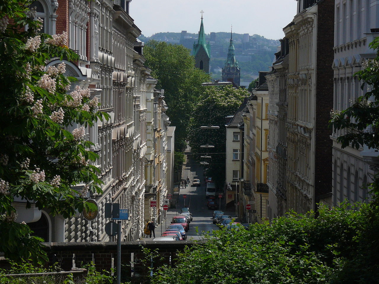
The city stretches along a narrow river valley, with steep slopes that shaped its street plan and architecture. Wuppertal's built environment reflects a patchwork of former towns and boroughs clustered around the Wupper; steep streets, terraces and parks are common. This topography influenced industrial development and transport solutions that are unique to the city.
History and economy
Wuppertal grew rapidly during the 19th-century industrial expansion as textile mills, mechanical workshops and related trades concentrated along the river. Several towns merged in the early 20th century to form the modern city. Over time the economy diversified toward engineering, services and education, while some traditional industries declined. The city now combines manufacturing, research and cultural services.
Culture, education and attractions
Wuppertal hosts cultural institutions and green attractions: museums, theaters and a notable municipal art collection, as well as parks and a botanical garden. The city is home to a major university that contributes to research and the local economy; see the university for study and collaboration opportunities. Important cultural names and ensembles have been associated with the city, enhancing its artistic profile.
Transport and the Schwebebahn
Wuppertal is internationally recognised for the Wuppertal Schwebebahn, a historic suspended railway inaugurated in the early 20th century and still in regular use. The line runs through the city center roughly 10 metres above the Wupper, offering a practical transit route and a tourist attraction simultaneously; more on the Schwebebahn and the suspended tram system. Local public transport combines buses, regional rail and the Schwebebahn to link neighborhoods and nearby cities.
Notable facts
- Distinctive valley setting and hilly urban fabric.
- Historical roots in 19th-century industry and textiles.
- A continuing mix of cultural institutions, green spaces and unique transport infrastructure.


Geography
Location
Wuppertal lies in an arc of the Wupper along the border with the Niederbergisches in the north and the Oberbergische Hochflächen in the south. The southeastern part of the urban area belongs to the Bergische Hochflächen with heights up to about 350 m, which are intersected by deep notch valleys of water courses. The northern part of the urban area is part of the Niederbergisch-Märkisches Hügelland, which has terrain elevations up to about 322 m. The valley of the Wupper itself is naturally called the Wuppertal depression.
The city is part of the Rhine-Ruhr and Rhineland metropolitan regions, the Rhineland Regional Association and the Bergisches Städtedreieck.
Due to the considerable differences in altitude, there are numerous stairs and steep streets. Wuppertal is considered the city with the most public stairs in Germany and is the "San Francisco of Germany" for film director Tom Tykwer - a native of Wuppertal.
Geology
Wuppertal lies on the edge of the Rhenish Slate Mountains, a German low mountain range whose rocks mainly date back to the Devonian period (approx. 416-360 million years ago) and the Carboniferous period (approx. 360-300 million years ago). In the southeastern parts of the city, the oldest geological rocks are found in the form of clay slate, greywacke and conglomerates of the Lower Devonian. To the northwest, alternating sequences of Middle Devonian schistose clays, silts and greywackes are found.
A subsidence of the earth's surface and the seabed led to the formation of reef complexes in the later Middle to Upper Devonian, the mass limestone of which extends in a northeast-southwest direction across the Wuppertal urban area. It is part of the Rhenish-Westphalian limestone range, which runs from the northern edge of the Sauerland and the Bergisches Land from Düsseldorf via Wuppertal and Iserlohn to Brilon.
As early as the 9th century, lime was extracted, and in the district of Dornap and the neighbouring towns of Mettmann and Wülfrath there has been open-cast lime mining since industrialisation until today. A 19th century lime funnel kiln has been preserved as an industrial monument in the Elberfeld-West district. In the district of Wichlinghausen there are small deposits of the volcanic rock diabase (greenstone), which was formed on the sea floor in the Upper Devonian. In the north, slate, quartzite and greywacke from the Carboniferous period are preserved as the youngest layers.
The deposited rocks were folded and shifted against each other in the course of the earth's history, partly under increased pressure and high temperature. Therefore, folded and steeply placed rock layers can often be observed, especially well in the Barmer Nordpark.
In the Tertiary period (about 65-2.6 million years ago), sands and gravels were deposited in some valleys. During the Ice Age, very fertile, yellow-brown loess was blown over the entire area. The 9.5-kilometre-long geology nature trail "Geopfad" leads from the Sedanstrasse grammar school via the Barmer Nordpark to the nature reserve of the sinkhole area in the Hölken.
Extension of the urban area
The city boundary has a length of 94.5 kilometres. The valley of the Wupper stretches with a length of 33.9 kilometers mainly from east to west and has widenings with widths of up to two kilometers, in which the city centers Barmen and Elberfeld are located.
The highest point is the elevation Lichtscheid with 350 meters above sea level, the lowest point with 101 meters above sea level is near Müngsten, where the Morsbach flows into the Wupper.
Neighboring communities
Of the cities and municipalities surrounding Wuppertal, Hattingen, Sprockhövel, Schwelm and Ennepetal belong to the Ennepe-Ruhr district and Radevormwald to the Oberberg district. Remscheid and Solingen are independent cities, Haan, Mettmann, Wülfrath and Velbert belong to the district of Mettmann.
| Sprockhövel | ||
| Mettmann |
| |
| Radevormwald |

City breakdown
The city area has been divided into ten boroughs since 1975.
|
|
For statistical purposes, the city districts are divided into a total of 69 quarters.
With almost 66,000 inhabitants, Elberfeld is the largest urban district, Ronsdorf the smallest with about 21,000 inhabitants. The Herbringhausen residential quarter in the Langerfeld-Beyenburg district is the largest residential quarter in terms of area.
See also: List of boroughs and districts of Wuppertal
Urban structure
The urban structure represents a special typology. The elongated east-western valley location results in an agglomeration band that has no parallel in the German region in terms of urban space. Along an axis consisting of the main road (Bundesstraße 7), the main railway line and the river with the suspension railway, all the important functions of the city are lined up along a length of about 15 kilometres.
Today's city as a whole has developed from several individual towns and villages, but at the same time is organised in a decentralised manner. There is no clear centre formation; with Elberfeld and Barmen, Wuppertal has two larger urban centres as well as five further districts (Beyenburg, Cronenberg, Langerfeld, Ronsdorf and Vohwinkel) with predominantly small-town elements and their own centres. The topographical location ensures cohesion as an urban unit with a common industrial history and similar growth conditions. The large differences in altitude allow a far-reaching view over the city in many places. The Gründerzeit villa districts Brill, Zoo and Toelleturm, situated on the hillside, are close to the centres.
The topography only allowed limited expansion of commercial and industrial sites in the valley. The Bayer Group, which was established here, therefore had to relocate at the end of the 19th century and expanded in Leverkusen. Since then, commercial sites have been built mainly on the outskirts of the city.
The structural change that began at the end of the 20th century as a result of increasing deindustrialisation caused a de-functionalisation with dereliction and empty spaces in the city and a strong population decline that lasted until 2012. However, the medium-sized industrial structure led to modernisation effects such as the "Ideon Park" on the former Quante site and the "Engineering Park" on the site of the former Wuppertal barracks. Civic initiatives such as the Waldfrieden Sculpture Park, the "Pina Bausch Foundation", the Junior Uni and the Nordbahntrasse also enrich the city. Here, companies and institutions, foundations and associations, citizens have donated as well as made extensive contributions in kind.
Green spaces
Typical for Wuppertal are the green spaces and hillside forests, which also in the inner-city area extend in many places to within a few hundred metres of the valley axis. In a much-cited ranking from 2013, Wuppertal was named Germany's greenest major city out of a total of 25 major cities. In terms of all 79 cities with more than 100,000 inhabitants, Wuppertal came 25th with a 77.5% green share according to a satellite image analysis in 2016. In this statistic, too, at least no major city in Germany has a higher green share.
In terms of urban development, since the 2010s there has been talk of a densification of the green residential areas on the Wuppertal heights, such as Scharpenacken, Nächstebreck, and Kleine Höhe. Green areas are being built on with houses or large shopping markets, the old tree population, the local recreation areas and fresh air zones are being reduced, biotopes are being destroyed.
The Düsseldorf district government is planning further development of green spaces. The urban land-use planning of the city of Wuppertal weighs up the effects as follows: "The probable significant environmental effects are accepted by way of planning consideration due to the high demand for residential building land".
Climate
Wuppertal is located in the north-west German climatic region, whereby the maritime, sub-Atlantic cool temperate climate leads to generally cool summers and relatively mild winters. Influences of the relief (valley situation) and the land use lead to locally different characteristics of the climatic parameters. At the heights of the Bergisches Land, humid Atlantic air masses meet an obstacle for the first time with the prevailing westerly air currents and are dammed up. As a result, the clouds rise into higher air layers, which are usually colder, condense and rain down as rising rain. In Elberfeld about 1100 mm of precipitation are recorded, this value rises to 1200 mm in Barmen/Oberbarmen.
The months with the highest precipitation are September and July, while the most rainy days are in December. The average annual rainfall of 1116 mm in the valley and 1183 mm on the heights is among the highest in a German city. The saying "In Wuppertal, children are born with umbrellas" reflects this fact in the vernacular.
| Wuppertal | ||||||||||||||||||||||||||||||||||||||||||||||||
| Climate diagram | ||||||||||||||||||||||||||||||||||||||||||||||||
| ||||||||||||||||||||||||||||||||||||||||||||||||
| Monthly average temperatures and precipitation for Wuppertal
Source: DWD, data: 2015-2020; WeatherOnline | |||||||||||||||||||||||||||||||||||||||||||||||||||||||||||||||||||||||||||||||||||||||||||||||||||||||||||||||||||||||||||||||||||||||||||||||||||||||||||||||||||||||||||||||||||||||||||||||||||||||||||||||||||||||||||||||||||||||||||||||||||||||||||||||||||||||||||
The average annual temperature is around 11 °C. During the growing season, when the temperature exceeds 10 °C on 150 to 180 days, the average temperature is 13 to 16 °C. July is the warmest month with mean temperatures of 19.4 °C, January the coldest with 3.4 °C. On average, there are 26 summer days with temperature maxima above 25 °C and 62 frost days.
The mean annual sunshine duration of 1300 to 1400 hours is somewhat below the German mean of 1550 hours. The mean annual wind speeds vary from about 2.9 m/s in the valley to about 3.8 m/s at higher altitudes. The natural vegetation has very favourable growing conditions with these climatic characteristics, but due to the danger of heavy rainfall and late frosts the conditions for agriculture are rather difficult.
Air quality and environmental protection
Preserving clean air or restoring it is the goal of a systematic air pollution control policy that has been pursued since 1956. The Clean Air Plan for Wuppertal drawn up by the Düsseldorf district government dates from 2008 and is currently valid in the first update of 2013. Despite considerable efforts, the air quality in Wuppertal is still considerably polluted by nitrogen dioxide (NO2). The immission measurements continue to show significant exceedances of the NO2 limit value (annual mean) of 40 µg/m³ as specified in the Ordinance on Air Quality Standards and Emission Ceilings. The measured values at the station "Gathe" for example, were 55 µg/m³ annual mean for 2011, and 64 µg/m³ for 2016 at the station "Briller Strasse". In Wuppertal, about 194,000 citizens - corresponding to 54 % of the population - live in an NO2 pollution area. In this respect, there is an urgent need for action to further reduce NO2 pollution in the planning area.
Natural areas
29% (equivalent to 4858 hectares) of the urban area is forest and open space, 7.8% (equivalent to 1318 hectares) is parks and green space, 21% (about 3500 hectares) is used for agriculture. There are also about 8000 allotment gardens on 380 hectares and 46 cemeteries on an area of 160 hectares. In Wuppertal there are 20 nature reserves and natural monuments managed by the North Rhine-Westphalia State Agency for Nature, Environment and Consumer Protection (LANUV).
Some areas close to the city centre were not built on because of the steep terrain. Some rock formations reach as far as the Wupper and are still tree-covered today. Some of these areas have been turned into parks or landscaped gardens. Elsewhere, such as in Sonnborn at the level of the stadium or on the southern slope of the Hardtberg between Barmen and Elberfeld, the rocks along the main roads of the valley axis were slightly removed in favour of the extraction of building material as well as easier development.
Woods
In the city area as well as in the neighbouring towns and communities there are numerous wooded areas that make Wuppertal a city in the countryside. The Burgholz State Forest in Cronenberg is Germany's largest forestry arboretum with its unique collection of various woody plants, some of which are exotic, covering an area of almost 250 hectares. Visitors can explore the forest on nature trails.
The Gelpetal nature reserve, together with the Saalbach valley, forms a wooded recreational area to the south of the city, where iron and steel have been processed by the proto-industry since the 14th century. Along an industrial history trail you can see the remains of former hammer mills and grinding mills.
The Scharpenacken recreational area, which borders the Barmer Wald forest, is characterised by extensive woodland and open spaces with unobstructed views. It is under landscape protection and is home to some valuable biotopes, such as the Schmalenhofer Bach stream, the largest rough pastures in the Niederbergisches Land region and some small species-rich wetland biotopes near Erbschlö.
Other forests in the southern heights are the Christbusch and the Kothener Busch. In the southeast, near the village of Linde, lies the state forest Marscheider Wald, an extensive forest area, which is followed to the east by the Herbringhauser Wald and the Sondernbusch.
Adjacent to the north, the nature reserve Deilbachtal and the Felderbachtal form the connection to the southern part of Essen. There is also a game reserve on the Ehrenberg between Langerfeld and Schwelm, and another in the Nordpark in Barmen.
The high recreational value of Wuppertal's forests is evident in the 650 kilometres of hiking trails, 50 kilometres of bridle paths, 18 weather shelters and 14 hiking parking areas.
Waters
The more than 500 flowing waters (streams and rivers) are particularly characteristic landscape elements with an average flowing water density of about 1.9 km of water length per square kilometre. Furthermore, there are three larger standing waters, the Herbringhauser dam, the Ronsdorfer dam and the Beyenburger reservoir. Many of the watercourses flow into the Wupper or one of its tributaries in the urban area, which is why they only run above ground outside the peripheral areas of the city.
See also: List of water bodies in Wuppertal


Religions
Confession statistics
In Wuppertal, the number of Protestant church members fell to 90,373 in 2019. and of Catholic church members to around 72,500 At the end of 2018, of 354,382 residents, 92,704 (26.2%) belonged to the Protestant church and 73,400 (20.7%) to the Roman Catholic church. At the end of 2016, 28.5% (2012: 29.6%) of residents belonged to the Protestant Church and 21.3% (2012: 23.7%) to the Roman Catholic Church. 50.1% (2012: 46.7%) belonged to another denomination or religion or were non-denominational. Wuppertal is considered the city in Germany with the most different religions, sects and congregations. The later town of Ronsdorf was founded by the Christian sect of the Zionites under Elias Eller, which, however, no longer exists today. According to various sources, about 80 to 90 different religious communities exist in the city.
See also: List of religious congregations in Wuppertal and List of religious buildings in Wuppertal
Christianity
The Elberfeld Bible (abbreviated EB), named after the Wuppertal district, is an important German translation of the Bible, first published in 1855 (New Testament) and 1871 (Old Testament). The literalness of the translation has priority over linguistic beauty. Thus it became the model for many other translations.
Evangelical
In the 16th century, the Reformation according to the Reformed confession was introduced in Elberfeld (1566 by Peter Loh), Barmen and most other present-day districts of Wuppertal. During the Spanish occupation, Protestant worship was banned between 1625 and 1627. From 1690 there were Lutheran congregations in Elberfeld, as later in other places. In Barmen, the Reformed congregation of Gemarke separated from the parish of Schwelm in 1702. The Lutheran congregation of Wichlinghausen also separated in 1744, and the Wupperfeld congregation separated from it in 1778. In some smaller towns, separate Reformed or Lutheran congregations were formed much later, for example in Beyenburg in 1854 and in Vohwinkel in 1886.
After the transfer of the city of Elberfeld to Prussia, the Reformed and Lutheran congregations were initially subject to the consistory in Düsseldorf (1814-1816, 1934-1947), Cologne (1816-1826; temporarily synchronous) and Koblenz (1822-1934), which in 1826 became the sole seat of the entire Rhenish Provincial Church (today the Evangelical Church in the Rhineland) of the Evangelical Church in Prussia.
Elberfeld and Barmen became the seat of a district synod (today a church district), to which the Protestant congregations of Sonnborn, Vohwinkel, Cronenberg and Ronsdorf also belong to this day, provided they are not free churches. On 1 January 2005, the church districts of Elberfeld and Barmen, which had been separate until then, merged to form the church district of Wuppertal, to which all the Protestant parishes in the Wuppertal city area belong, with the exception of the parishes of Dönberg and Schöller (both in the Niederberg church district).
Although the union between Reformed and Lutheran congregations was introduced in Prussia in 1817, the respective congregations remained true to their previous traditions in their perception. Thus, in Wuppertal today, a distinction is still made between Reformed and Lutheran congregations within the united regional church. Some congregations were founded from the beginning as "united" congregations, for example Unterbarmen and Küllenhahn, whereas in Ronsdorf Reformed and Evangelical Lutheran congregations still exist separately, which is unique for a district congregation in the Rhenish Regional Church today. As a reaction to the Rhenish-Westphalian Church Order of 1835, which prescribed a unified liturgy for the Prussian Protestant churches, an Old Lutheran congregation and the Dutch Reformed congregation separated from the united Prussian church for confessional reasons. Even today there are two Lutheran congregations: In Barmen and Elberfeld, which belong to the Rhineland church district of the Independent Evangelical Lutheran Church, and the Dutch Reformed congregation, which has joined the Evangelical Old Reformed Church in Lower Saxony.
Catholics
The area of today's city belonged to the archdiocese of Cologne, Elberfeld and Unterbarmen to the archdeaconry of the cathedral deacon in the deanery of Neuss, Oberbarmen to the archdeaconry of St. George in the deanery of Lüdenscheid. Around 1300 Elberfeld became a parish of its own, having previously belonged to Richrath (now Langenfeld (Rhineland)). The few Catholics, six families in Elberfeld in 1658, three in Barmen in 1708, belonged to the archbishopric of Cologne even after the Reformation. In Barmen a new Catholic church was built between 1708 and 1721, pastored by Franciscans from the monastery in Wipperfürth. Around 1800 there were 2,000 Catholics there, and in the 19th century the number increased sharply throughout Wuppertal. In 1830 there were nearly 5,800 Catholics in Elberfeld. Several parishes were established in the towns. Both Elberfeld and Barmen became the seat of a deanery within the archdiocese of Cologne. Today both deaneries together form the "City Deanery of Wuppertal". The parishes of Cronenberg, Ronsdorf (formerly part of Barmen) and Vohwinkel also belong to the deanery of Elberfeld, while the parishes of Langerfeld and Beyenburg belong to the deanery of Barmen. The main church of Wuppertal's Catholics is the classicist St. Laurentius Church in Elberfeld, which has held the title of papal basilica minor since 2014.
Free Churches
Among the early free church plantings was that of the first Baptist congregation by Julius Köbner. In 1854, the first Free Evangelical congregation in the German-speaking world of that time was founded by the businessman Hermann Heinrich Grafe together with five other men in Elberfeld. This laid the foundation for the founding of the Federation of Free Evangelical Congregations in Germany 20 years later. At about the same time, in 1875, the first German grouping of Seventh-day Adventists was founded in Vohwinkel.
Jehovah's Witnesses
The "Christian special communities" include Jehovah's Witnesses (until 1931 Bible Students), whose first German branch was in Elberfeld in 1902. Here, for the time being, an office of the "Watch Tower Society" was opened. A year later it was expanded into a branch office ("Bethel") of the Watchtower Society. In addition, the first German general meeting of the Bible Students was held in Elberfeld in 1905. The branch office moved to Barmen in 1908, where it remained until 1923. During National Socialism they too were subjected to severe persecution. Today, Jehovah's Witnesses are represented in Wuppertal by four German and more than ten foreign-language assemblies (congregations) and groups. They hold their meetings (services) in two Kingdom Halls (meeting places) in Wuppertal.
More churches
The New Apostolic Church is represented in Wuppertal by six congregations and a total of 1383 congregation members (December 2017).
Islam
The number of Muslims is officially estimated at around 28,000. Of these, an estimated 60% are of Turkish origin, and about a quarter are likely to be immigrants from Morocco. They are predominantly Sunni and are organised in various communities, which roughly represent the various groupings of Turkish religious associations (DİTİB, VIKZ, Milli Görüş) in Germany. In addition, there are also two community centres of the Alevis, a community centre of the Bosnians as well as some Arabic-speaking communities. On Krummacherstrasse in Varresbeck, the construction of Germany's first Muslim cemetery with burials according to Islamic usage has been planned since 2015.
Judaism
Jewish community members did not exist in Elberfeld again until 1694, after they had been expelled in 1595 by order of the Duke of Berg. In Barmen two families were counted in 1802. In 1861 the Jews of both towns were able to found a joint Israelite congregation, which, however, perished during the National Socialist era. Since 1994, the Old Synagogue Wuppertal meeting place at the former site of the Elberfeld synagogue has been a reminder of the Jewish community, almost all of whose members were expelled and murdered during the Nazi regime. Due to the influx of Jews from the states of the former Soviet Union, the number of community members rose from 65 to over 2,000 people in the 1990s, which corresponds to 0.6 percent of the population. On December 8, 2002, a new synagogue building, the Bergische Synagoge in Barmen, was inaugurated. Moshe Katzav was the first Israeli president to attend the opening of a synagogue in Germany. The construction was also supported by the cities of Remscheid, Solingen and Velbert.
Other religious communities
In the Buddhist Centre Wuppertal, the Diamond Way Buddhism of the Karma Kagyu lineage is taught, and there are also two groups of Mahayana Zen Buddhism. Especially Tamils from Sri Lanka pray in the Hindu temple in Unterbarmen.
Interreligious dialogue
The Society for Christian-Jewish Cooperation in Wuppertal is dedicated to Jewish-Christian dialogue.
In the interreligious working group Round Table Wuppertal, in which the Jewish religious community, the Protestant and Catholic churches as well as the local Islamic community participate, a Jewish-Christian-Muslim calendar is compiled and published every year.
Confessional Synod
During the time of National Socialism, Wuppertal became known for the Confession Synod, which was held in the Gemarker Church from 29 to 31 May 1934. It was convened by the Confessing Church and attended by Lutheran, Reformed and Uniate delegates. It was here that the so-called Barmer Theological Declaration came into being, which is considered one of the confessional foundations of the Protestant Church as well as the theological foundation during the time of National Socialism.


Questions and answers
Q: Where is Wuppertal located?
A: Wuppertal is located in the west of Germany, in the state of North Rhine-Westphalia.
Q: What is the population of Wuppertal?
A: Wuppertal has about 360,000 inhabitants.
Q: What is a tourist attraction in Wuppertal?
A: A well-known tourist attraction in Wuppertal is the Wuppertal Schwebebahn, a tram hanging about 10 meters (33 feet) above ground.
Q: What is the Wuppertal Schwebebahn?
A: The Wuppertal Schwebebahn is a tram hanging about 10 meters (33 feet) above ground.
Q: Is there a university in Wuppertal?
A: Yes, there is a university in Wuppertal.
Q: What is the proximity of Wuppertal to Düsseldorf?
A: Wuppertal is next to Düsseldorf.
Q: In what state is Wuppertal located?
A: Wuppertal is located in the state of North Rhine-Westphalia.
Related articles
Author
AlegsaOnline.com Wuppertal — city in North Rhine-Westphalia, Germany Leandro Alegsa
URL: https://en.alegsaonline.com/art/109277
Sources
- destatis.de : "Alle politisch selbständigen Gemeinden mit ausgewählten Merkmalen am 31.12.2018 (4. Quartal)" · web.archive.org
- destatis.de : destatis.de/DE/ZahlenFakten/LaenderRegionen/Regionales/Gemeindeverzeichnis/Administrativ/…
- it.nrw.de : "Amtliche Bevölkerungszahlen"
- commons.wikimedia.org : Wuppertal