Worms, Germany — history, landmarks, and cultural significance
Worms is an historic city on the Rhine in Rhineland-Palatinate, Germany, known for its Romanesque cathedral, medieval Jewish heritage, Nibelungen legend links and the Diet of Worms involving Martin Luther.
![]()
Worms is a city on the left bank of the Rhine in the German state of Rhineland-Palatinate. Its origins reach back to Celtic and Roman periods, and it often figures among German cities that claim very early urban beginnings. Located between the Rhine-Main and Rhine-Neckar metropolitan areas, Worms has served as a regional centre for administration, trade and culture. The city's name appears in Latin as Wormatia, and in historic sources it also appears as Borbetomagus.
Image gallery
10 Images


Geography and municipal character
Worms lies on low, fertile ground beside the Rhine and is associated with the surrounding wine-growing landscapes of Rheinhessen. The urban area combines a preserved historic core with 19th- and 20th-century expansions and suburban districts. Its transport links have long included river connections and road and rail corridors that tie it to neighboring cities, contributing to a mix of light industry, services and tourism in the local economy.
Historical overview
The city has a long, layered history. Archaeological and written sources indicate settlement in the Celtic and Roman eras; later it developed into an important medieval imperial town. Worms features prominently in both documentary medieval history and in German cultural memory. One of the best-known episodes from early modern times is the Diet of Worms (1521), where Martin Luther famously refused to recant his writings before the imperial assembly. Over centuries Worms was shaped by its strategic location on the Rhine, imperial politics and the ebb and flow of trade and warfare.
Cultural heritage and landmarks
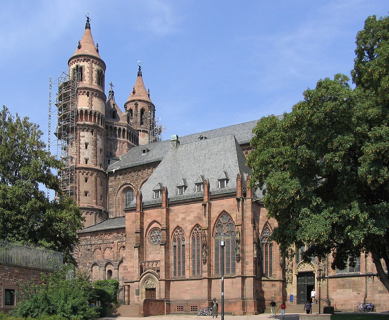
Worms is particularly notable for several well-preserved cultural monuments. Its Romanesque cathedral, the Imperial Cathedral of St. Peter, stands among the three large Romanesque cathedrals of the region and is a focal point of the historic skyline. Other important sites include the medieval Jewish cemetery often called the "Heiliger Sand," the Nibelungen Museum that explores the city's connection with the Germanic epic tradition, and surviving defensive structures and historic squares.
- Worms Cathedral (Imperial Cathedral of St. Peter) — Romanesque architecture and religious centre
- Heiliger Sand — a medieval Jewish cemetery reflecting centuries of Jewish life
- Nibelungen Museum and cultural references to the Nibelungenlied
- Various Luther memorials and sites linked to the Diet of Worms
The city's identity is intertwined with literature and religion: it appears in the medieval Nibelungenlied, and it is one of the so-called SchUM cities (an acronym derived from the Hebrew names of Speyer, Worms and Mainz), a group known for their central role in medieval Ashkenazi Jewish culture and law.
Community, remembrance and modern life
Worms preserves layers of memory: a Jewish presence that shaped local law, commerce and scholarship for centuries; Christian institutions embodied in its cathedral and parish churches; and civic traditions rooted in its medieval municipal status. The 20th century brought traumatic loss for the Jewish population during the Holocaust, and public commemoration and cultural restoration have been important in the city's recent civic life. Today Worms combines heritage tourism, festivals (including events celebrating the Nibelung saga), regional wine culture and service-sector activities, while museums, guided tours and preserved historic sites draw visitors interested in history, architecture and literature.
Visitors and students of history find in Worms a compact example of central European continuity and change: an ancient riverside settlement that has accommodated Roman roads, imperial politics, medieval communities, Reformation-era conflict and contemporary efforts to remember and interpret its multifaceted past.


Geography
Geographical position
Worms is located in the eastern part of Rhineland-Palatinate in the Upper Rhine Plain. It is located in the southeastern part of the Rheinhessen region between Mainz (about 40 kilometres north) and Ludwigshafen (about 20 kilometres south) on the left, western bank of the Rhine. In the northern part of the city, the Pfrimm flows into the Rhine, while the Eisbach (also called Altbach here), which also flows into this stream, flows through the southern parts of the city. In the extreme southeast of the city runs the lower reaches of the Eckbach, which also flows into the Rhine.
To the southwest, 15 km away, lie the foothills of the Palatinate Forest, to the west the hilly landscape of the Wonnegau, and on the other side of the Rhine, the Hessian part of the Odenwald adjoins the plain.
The lowest point of Worms is at 86.5 m above sea level near the northern district of Ibersheim on the former river island of Ibersheimer Wörth, the highest point is at 167 m on the western city boundary between the district of Pfeddersheim and the adjoining Nieder-Flörsheim to the west, directly on Nieder-Flörsheimer Straße (state road 443).
Catchment area
As a medium-sized centre, Worms is directly assigned to the Wonnegau region with the municipalities of Eich, Monsheim and Wonnegau. The city's catchment area also includes parts of the Hessisches Ried and the northern Vorderpfalz.
Worms is located in the north of the Rhine-Neckar metropolitan region and in the south-west of the Rhine-Main region and is also considered a link between these conurbations due to its location. Therefore, in terms of spatial planning, the city belongs to both the Rhine-Hesse-Nahe planning region and the Rhine-Palatinate planning region, which is supervised by the Rhine-Neckar Regional Planning Association.
City breakdown
Worms is divided into eight boroughs with 19 districts. The 13 incorporated districts (subdivisions of the city districts 4 to 7), which at the same time form districts in addition to the central district of Worms, each have a local council, local head and local administration as local districts. With great self-confidence, they attach great importance to the preservation of their typical character. District-related wine festivals take place, for example, in the Herrnsheim castle courtyard of the former barons of Dalberg or at the medieval town walls of Pfeddersheim.
| Districts of Worms, according to city districts | ||||||||
| District | Area | Inhabitants | Location to the city centre | incorporated | District key | Postal code | Telephone area code | |
| City district 0 City centre | ||||||||
| 01 City centre | 0086 | 08.735 |
| - – | 073911 | 67547 | 06241 | |
| City district 1 City area south | ||||||||
| 11 City centre south | 0261 | 05.283 | bordering to the south | - – | 073911 | 67547 | 06241 | |
| 12 Karl Marx housing estate | 0643 | 01.117 | south of the centre (3 km) | - – | 073911 | 67547 | 06241 | |
| City district 2 City area north | ||||||||
| 21 City Centre North | 0723 | 09.725 | adjoining to the north | - – | 073911 | 67547 | 06241 | |
| City district 3 Southwest | ||||||||
| 31 City Centre West | 0155 | 10.001 | bordering to the west | - – | 073911 | 67549 | 06241 | |
| 32 Downtown Southwest | 0176 | 02.057 | bordering to the southwest | - – | 073911 | 67549 | 06241 | |
| Municipality 4 Western Suburbs | ||||||||
| 41 Pfiffligheim | 0393 | 03.386 | west of the centre | October 1, 1898 | 073913 | 67549 | 06241 | |
| 42 Hochheim | 0242 | 03.538 | northwest of the center | October 1, 1898 | 073909 | 67549 | 06241 | |
| 43 Neuhausen | 0185 | 10.508 | north of the center | April 1, 1898 | 073910 | 67549 | 06241 | |
| 44 Herrnsheim | 1217 | 06.270 | in the north of the city (5 km) | April 1, 1942 | 073903 | 67550 | 06241 | |
| 45 Leiselheim | 0259 | 02.104 | outside in the west (4 km) | April 1, 1942 | 073914 | 67549 | 06241 | |
| Municipality 5 Suburbs Southwest | ||||||||
| 51 Horchheim | 0575 | 04.795 | southwest of the centre (4.5 km) | April 1, 1942 | 073908 | 67551 | 06241 | |
| 52 Weinsheim | 0417 | 02.780 | in the southwest of the city (4 km) | April 1, 1942 | 073912 | 67551 | 06241 | |
| 53 Wiesoppenheim | 0354 | 01.733 | outside in the southwest (5,5 km) | June 7, 1969 | 073907 | 67551 | 06241 | |
| 54 Heppenheim | 1126 | 02.207 | outside in the southwest (9 km) | June 7, 1969 | 073906 | 67551 | 06241 | |
| Municipality 6 Western outskirts | ||||||||
| 61 Pfeddersheim | 1187 | 07.025 | outside in the west (7 km) | June 7, 1969 | 073905 | 67551 | 06247 | |
| 62 Abenheim | 1090 | 02.512 | outside in the northwest (10 km) | June 7, 1969 | 073904 | 67550 | 06242 | |
| Municipality 7 Northern Suburbs | ||||||||
| 71 Rheindürkheim | 0812 | 02.923 | outside in the north (8 km) | June 7, 1969 | 073902 | 67550 | 06242 | |
| 72 Ibersheim | 0972 | 00.714 | outside in the north (13 km) | June 7, 1969 | 073901 | 67550 | 06246 | |
see also: List of places in the independent city of Worms
Climate
Worms belongs to the climatic zone of the middle latitudes. The climate is continental. Due to its location in the Upper Rhine Plain between the Palatinate Forest and the Donnersberg in the west and the Bergstrasse and the Odenwald in the east, Worms is one of the warmest and driest places in Germany.
Air temperature
The long-term average of air temperature for the period 1951 to 1980 is 10.3 °C. In recent years, an increase in the annual mean air temperature has been observed. In 2008, for example, the averaged air temperature at Hagenstraße was 12.2 °C, while an averaged air temperature of 11.3 °C was measured five kilometres further west in Worms-Leiselheim during the same period. The air temperature for 2007 (averaged) was 12.7 °C at Hagenstrasse and 11.7 °C at Leiselheim. The higher average value of +1K of the annual mean temperature at Hagenstraße compared to the weather station Worms-Leiselheim is mainly based on the mostly warmer inner-city temperature values. In Worms the warmest month is currently July with 24 degrees Celsius daytime temperature. In contrast, the coldest month is January with an average of 3 degrees Celsius. The average daily high temperature in Worms is 14 degrees Celsius. At night, the average is 4 degrees Celsius.
Precipitation
The average precipitation for the period from 1961 to 1990 is 608 mm. Precipitation falls mainly in the months of May, June and July. In 2008, the annual precipitation at Hagenstraße was 492.2 mm, while an annual precipitation of 529.4 mm was measured five kilometres further west in Worms-Leiselheim during the same period.
The precipitation amounts for the year 2007 (averaged) - Hagenstraße 545.8 mm - Leiselheim 622.6 mm. The precipitation levels are low. They are in the lower quarter of the values recorded in Germany. Lower values are recorded at 23 % of the measuring stations of the German Weather Service. The driest month is February, the most precipitation falls in July. In July there is 2 times more precipitation than in February. Precipitation varies relatively strongly. Lower seasonal variations are recorded at 69 % of the measuring stations in Germany.
Sunshine duration
The long-term average (1951-1980) is 1709.7 hours. In the past years an increase of the annual average of sunshine hours was observed in Leiselheim. In 2007 there were 2007 hours of sunshine, a deviation from the long-term average of + 297.3 hours or + 17.4 %, in 2008 1886 hours were determined. This is a deviation from the long-term average of + 176.3 hours or + 10.3 %. In 2009 and 2010 the deviations were even more striking, + 343.3 hours or + 20.1 % (2009) and + 357.3 hours or + 20.9 % in 2010. Currently the sunshine duration is about 4 hours per day.


Population
Population development
In its heyday around 1500, Worms had about 6,000 inhabitants. Due to the destruction during the Thirty Years' War (1618-1648) and a plague epidemic in 1666/67, the number of inhabitants dropped to only 3,000. With the industrialization in the 19th century, the population growth accelerated. While in 1800 only 5,000 people lived in the town, in 1900 it was already over 40,000. The incorporation of several towns in 1969 brought an increase of 15,000 people to 78,000 inhabitants.
As of 31 December 2020, the official population for Worms was 83,459, according to figures from the Rhineland-Palatinate Statistical Office, making Worms the sixth largest city in Rhineland-Palatinate and the fourth largest in the Rhine-Neckar Triangle. Worms has a proportion of foreigners of 16.3%. The proportion of pupils with a migration background in general education schools in Worms was 22 % (school year 2012/13). This tops the list in a comparison of cities in Rhineland-Palatinate, after Ludwigshafen and Mainz. In day care facilities, over 49 % of children had a migration background at the beginning of 2015. In 2005, Worms was in second place among the independent cities behind Mainz (41.2 years) with an average age of 41.5 years. This means that Worms has a relatively young population, even in a nationwide comparison. In Rhineland-Palatinate the average age is 41.6 years and in Germany 41.8 years.
The following overview shows the population figures according to the respective territorial status. Up to 1820, these are mostly estimates, thereafter census results (¹) or official updates of the State Statistical Office. From 1871 onwards, the figures refer to the "local population", from 1925 onwards to the resident population and since 1987 to the "population at the place of principal residence". Before 1871, the number of inhabitants was determined according to non-uniform survey procedures.
|
|
| ||||||||||||||||||||||||||||||||||||||||||||||||||||||||||||||||||||||||||||||||||||||||||||||||||||||||||||||||||||||||||||||
¹ Census result
Confession statistics
According to the 2011 Census, 37.3% of residents in 2011 were Protestant, 27.9% were Roman Catholic, and 34.8% were non-denominational, belonged to another religious community, or did not specify. The number of Protestants and Catholics has since declined. Currently (as of May 31, 2021), of the residents, 28.2% are Protestant, 23.3% are Catholic, and 48.5% are non-denominational, belong to another religious community, or did not specify.


Related articles
Author
AlegsaOnline.com Worms, Germany — history, landmarks, and cultural significance Leandro Alegsa
URL: https://en.alegsaonline.com/art/109144
Sources
- destatis.de : "Alle politisch selbständigen Gemeinden mit ausgewählten Merkmalen am 31.12.2018 (4. Quartal)" · web.archive.org
- statistik.rlp.de : "Gemeinden in Deutschland mit Bevölkerung am 31. Dezember 2015"