
Wiltshire
Ceremonial county in South West England known for Stonehenge, Salisbury Plain and rolling chalk downland; includes towns such as Trowbridge and the unitary authority of Swindon.
Wiltshire, often abbreviated to "Wilts", is a ceremonial county in England, characterised by large areas of chalk downland, broad river valleys and a mixture of market towns, villages and open countryside. The county combines rich prehistoric archaeology with agricultural landscapes and more recent industrial and service economies.
Image gallery
10 Images




Geography and boundaries
Wiltshire shares land borders with several neighbouring counties: Hampshire, Dorset, Somerset, Gloucestershire, Oxfordshire and Berkshire. The county contains the extensive open plain known as Salisbury Plain, which occupies the south and south-west and is notable both for its archaeology and for use as a military training area. Much of the county—about 858,931 acres (approximately 3,476 km²)—is given over to agriculture, pasture and semi-natural downland, while more densely settled areas lie around the north and west.
History and archaeology
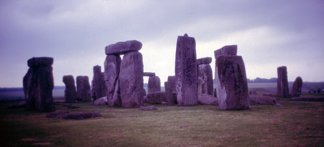
Wiltshire has an exceptionally long record of human activity. Neolithic and Bronze Age monuments, including the iconic circle at Stonehenge and the great henge and avenues at Avebury, give the county international archaeological importance; parts of these monuments are preserved as a World Heritage Site. Roman roads, medieval market towns and later industrial developments, particularly cloth manufacture in the west, have all left visible traces in the landscape and townscape.
Administration and settlements
The county town is Trowbridge, historically linked with cloth production and now an administrative centre; the town is also referenced at Trowbridge in many local histories and guides. Wiltshire contains the unitary authority of Swindon, a modern employment and transport hub, and other notable towns such as Salisbury, Devizes, Chippenham and Marlborough which serve as market and service centres for surrounding rural districts.
Landscape, biodiversity and land use
The chalk downland supports specialist grassland habitats and distinctive species adapted to thin soils and open conditions. Traditional mixed farming and sheep grazing have shaped the appearance of the downs for centuries. Woodland, river valleys and hedgerow networks provide further habitat diversity. Military training areas on Salisbury Plain have, paradoxically, helped conserve large tracts of open habitat by limiting development.
Economy, transport and culture
Wiltshire's economy includes agriculture, light manufacturing, defence-related activity, and a significant tourism sector centred on its prehistoric monuments, historic towns and countryside recreation. Transport links — notably road and rail connections through Swindon and Salisbury — connect the county to regional and national networks; Swindon's growth in the 19th and 20th centuries was closely tied to the railway industry.
Landmarks and visitor information
- Stonehenge and Avebury are the county's best-known prehistoric sites and attract visitors and researchers from around the world.
- Salisbury Cathedral, set at the edge of the plain, is noted for its medieval architecture and a surviving copy of the Magna Carta.
- Chalk hill figures, including various white horses, and long-distance footpaths across the downs are characteristic features for walkers and naturalists.
- Official area figures and administrative details are commonly cited in guides and statistical summaries; for example the county's recorded area appears as 858,931 acres in many references.
For practical information on visiting, conservation and local government arrangements consult local authorities and specialist heritage organisations linked from regional guides and visitor centres. Wiltshire remains a county where deep-time archaeology, agricultural traditions and modern life coexist within a largely rural environment.
Questions and answers
Q: What is Wiltshire?
A: Wiltshire is an English county.
Q: What counties does Wiltshire border?
A: Wiltshire borders the counties of Hampshire, Dorset, Somerset, Gloucestershire, Oxfordshire, and Berkshire.
Q: What is the unitary authority within Wiltshire?
A: The unitary authority within Wiltshire is Swindon.
Q: Where is the county town of Wiltshire located within the county?
A: The county town of Wiltshire is located in the west of the county at 51°19′11″N, 2°12′32″W.
Q: What is the size of Wiltshire?
A: Wiltshire covers 858,931 acres (3476 km²).
Q: What is the name of the county town of Wiltshire?
A: The name of the county town of Wiltshire is Trowbridge.
Q: What are the coordinates of the county town of Wiltshire?
A: The coordinates of the county town of Wiltshire are 51°19′11″N, 2°12′32″W.
Related articles
Author
AlegsaOnline.com Wiltshire Leandro Alegsa
URL: https://en.alegsaonline.com/art/108424