Adriatic Sea — geography, ecology and human uses
The Adriatic Sea is the northern arm of the Mediterranean between Italy and the Balkans. This article summarizes its geography, bathymetry, ecology, history, economic uses and modern environmental concerns.
Overview
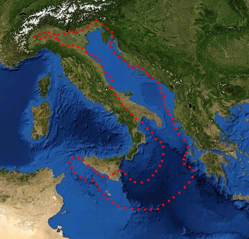
The Adriatic Sea is the long, narrow basin separating the Italian Peninsula from the Balkan Peninsula and forms the northeastern arm of the Mediterranean Sea. It stretches from the Gulf of Venice in the north to the Strait of Otranto in the south, and borders several countries on its shores. The sea has played a major role in regional trade, coastal settlement and maritime culture for millennia.
Image gallery
10 Images


Coastline and countries
The Adriatic’s coastline includes highly varied shorelines — wide lagoonal plains, steep karst cliffs and an archipelago of islands. Countries with Adriatic coasts include:
Dimensions and bathymetry
The basin is relatively narrow compared with open seas: the width averages roughly 160 km across the central part. At its southern exit the Strait of Otranto links the Adriatic to the Ionian Sea and is about 85–100 km wide. The Adriatic is also shallow by oceanic standards: its average depth is near 240 m, although there are deep troughs in the south where depths exceed 1,460 m (approximately 800 fathoms), notably east of Monte Gargano and south of Dubrovnik.
Ecology and resources
The sea supports diverse habitats — seagrass beds, tidal lagoons, rocky shores and an extensive island network — which sustain fisheries, shellfish aquaculture and tourism. Important commercial species include various small pelagics and benthic fish; coastal wetlands and estuaries are important bird and nursery habitats. Marine protected areas and seasonal fishing restrictions exist to help conserve stocks and sensitive communities.
History, navigation and modern use
Since antiquity the Adriatic has been a corridor for trade and cultural exchange: Greek colonists, Roman fleets and later the maritime republics and Ottoman routes all relied on its waters. In modern times the sea remains crucial for ports, ferry links, shipbuilding and a highly developed tourism sector along the coasts and islands.
Contemporary concerns
Environmental pressures include pollution from urban and industrial sources, habitat loss along low-lying shores, overfishing in some areas and the spread of non-native species via shipping. Regional cooperation among bordering states focuses on monitoring water quality, protecting key habitats and balancing economic uses with conservation.
History
Ancient
The first settlement in the area was of Venetian origin from the 12th to the 9th century BC. They consisted of stacked houses in the wetlands when they were still by the sea. At that time the Adriatic, the main river in the Po, flowed into the sea in the area. The Vilanova culture was named after the archaeological site in the village of Vilanova near Bologna (Etruscan: Felsna) and flourished in the region from the 10th to the 6th century BC. The foundation of the classical atrium dates from 530 to 520 BC.
After the canal dried up, the Etruscans built ports and settlements in Adria. The port continued to thrive in the late sixth century BC. The area controlled by the Etruscans of Pugu is usually called Padan Etruria and is concentrated along the Tyrrhenian River to the south Arno coast.
From the Greeks of Aegina to Dionysius I of Syracuse colonized the city and made it a trading center. The Greeks began trading with the Venetians at least in the 6th century BC. Especially amber, originally from the Baltic Sea.
The Celts frequently invaded the Po Valley, causing friction between Gauls and Etruscans and intermarriage, as evidenced by the epic inscriptions with Etruscan and Celtic names of. The city was settled by Etruscans, Venetians, Greeks and Celts.
The Roman writer and naval commander Pliny (Pliny the Elder) wrote that the Atria canal system was originally established by the Tuscans (ie Etruscans) to divide the river into the seven seas. On the coast of the Atriani Marsh, the famous port of Atria in Tuscany, formerly called Atriatic for the sea, is now called Adriatic. The "seven oceans" are interconnected coastal lagoons. Separated from the open sea by sand pits and barrier islands. The Etruscans extended this natural inland waterway with the new canal, extending Po's tidal navigation capabilities north to Atria. Even during the time of Emperor Vespasian, the Asakusa kitchen could be moved from Ravenna to the heart of the Etruscans. Under Roman occupation, the city was ceded to the former Greek colony of Ravenna as the Great Delta continued to silted up and the coast moved further east. The sea is now about 22 kilometers from the Adriatic Sea.
Carlo Bocchi made the first exploration of ancient Atria and published it as "Importanza di Adria la Veneta". The collections of the Bocchi family were opened to the public at the beginning of the 20th century and form a large part of the antiquities collection of the Civic Museum.
There are some thoughts on the etymology of the ancient place name Adria / Atria. One theory is that it comes from the intent word "water, sea" (Venetian).
Middle Ages and Modernity
When the Western Roman Empire collapsed, the port of Adria had lost most of its importance. After Deacon Paul registered the catastrophic flood, Adria became the territory of the Archdiocese of Ravenna. After the local hydrology had been completely changed, the flood finally receded in 589.
After a period of independent municipalities, it was owned by the Estonians of Ferrara and in the 16th century by the Republic of Venice. At that time Adria was a small village surrounded by malarial swamps. When Polesine was reconquered in the same century, it regained importance. During the Napoleonic Wars it was first under France, then under Austria, and in 1815 was assigned to it as part of Veneto in Lombardy after the Congress of Vienna.
Geography
Location
The Adriatic Sea is 820 kilometres long from northwest to southeast and 160 kilometres wide on average. The greatest width is about 220 kilometers. It covers an area of 132,000 square kilometres and is between 40 and 200 metres deep in the northern basin (north of the promontory of Monte Gargano). The southern part is significantly deeper, reaching its greatest depth of 1260 metres between Durrës and Bari. The southern end of the sea is formed by the Strait of Otranto, where the distance between Italy and Albania is 71 kilometres.
Bordering countries are Italy, Slovenia, Croatia, Bosnia and Herzegovina, Montenegro and Albania.
Coasts
The northwestern part, the upper Adriatic, is flat with some lagoons, some of them large. The largest is the lagoon of Venice. After that, the Italian east coast becomes abruptly mountainous south of Gabicce Mare, where the entire coastline is relatively straight. Apart from the Tremiti Islands, there are no offshore islands. Only the Gargano Mountains, located in Apulia, protrude into the Adriatic Sea as a peninsula about 50 kilometres to the east. The west coast of the Adriatic ends at the Italian boot heel near Otranto.
The east coast of the sea with the peninsula of Istria at its northern end is mountainous throughout. A good part of the east coast is occupied by the Croatian landscape of Dalmatia. The Bay of Kotor in Montenegro is the largest bay in the Adriatic Sea, about 30 kilometres long. The extreme southeast is again flat and marshy. Along the entire east coast are well over a thousand islands.
South of Shkodra in Albania, along the coast of the Drin Gulf and also further south, stretches a wide lowland with partly untouched sandy beaches. Long lagoons have formed at many river mouths. At the bay of Vlora the Adriatic coast ends. South of the city of Vlora begins the Albanian Riviera on the Ionian Sea.
Islands
- Albania: Sazan off the Karaburun Peninsula near the Strait of Otranto
- Bosnia and Herzegovina: Mali Školj and Veliki Školj
- Italy: Tremiti Islands, north of the Gargano Peninsula
- Croatia: Brač, Cres, Čiovo, Dugi Otok, Hvar, Ilovik, Ist, Jabuka, Korčula, Krk, Lastovo, Lopud, Lošinj, Mljet, Pag, Premuda, Olib, Rab, Šipan, Susak, Vis, Unije and many others. In total there are 1246 islands in the Croatian Adriatic. Only 47 of them are inhabited.
- Montenegro: Sveti Stefan, Sveti Nikola and the group of small islands in the Bay of Kotor: Mamula, Sveti Marko, Ostrvo Cvijeća ("Island of Flowers"), as well as Gospa od Škrpjela and Sveti Đorđe off Perast (List of islands in Montenegro).
Inflows
Major Adriatic tributaries (selection):
- Albania: Buna (border river with Montenegro), Shkumbin, Vjosa
- Italy: Brenta, Adige, Isonzo, Livenza, Piave, Po, Reno, Sile, Tagliamento
- Croatia: Cetina, Krka, Mirna, Neretva, Rječina, Zrmanja
- Montenegro: Morača, Buna (border river with Albania)
- Slovenia: Drnica, Rižana
Climate
The climate is characterized by very warm, dry summers with little rain and mild, partly rainy and humid winters. In summer, steady, lightly windy weather conditions prevail. In winter, the Adriatic region is under the influence of low-pressure areas from the Atlantic. This occasionally results in warm southerly winds (scirocco) and cold northerly winds (bora/bura).
Level
The term "metres above Adriatic Sea" is used to indicate the height above sea level with three possible reference heights. Thus, in the Yugoslav successor states, the indication is referred to the mean water level at the Molo Sartorio from 1900 (Trieste 1900 water level), while an identical height definition for Albania is referred to the Durrës water level, the mean water level in the city of Durrës. In Austria, the gauge is used to refer to a mean level of the Adriatic Sea at the Molo Sartorio of Trieste (gauge Trieste 1875), established in 1875.


Related articles
Author
AlegsaOnline.com Adriatic Sea — geography, ecology and human uses Leandro Alegsa
URL: https://en.alegsaonline.com/art/1083