Wilhelmshaven: North Sea Port City and German Naval Base
Wilhelmshaven is a port city on the Jade Bight in Lower Saxony, Germany. Founded as a Prussian naval base, it is today a major commercial and military harbour with container, energy and maritime research roles.
Overview
Wilhelmshaven is a coastal city on the western shore of the Jade Bight, a wide bay opening onto the North Sea. It lies in Lower Saxony and is part of modern Germany. The town developed around large artificial harbours and is best known as a principal naval base and port complex supporting both military and civilian shipping.
Image gallery
8 Images


History
The settlement began in the 19th century when Prussia established a deep-water harbour for its navy. Over ensuing decades the waterfront expanded with docks, shipyards and defensive installations. Wilhelmshaven played a prominent maritime role through the early 20th century and suffered extensive damage during the Second World War; much of the postwar era has been a process of reconstruction and adaptation toward peacetime industry and commerce.
Port, economy and infrastructure
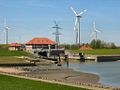
The harbour area combines military facilities, commercial terminals and industrial installations. It hosts a major naval base and associated ship-repair yards, oil and fuel terminals, and a deep-water container terminal (JadeWeserPort) designed to accommodate large modern vessels. The port also supports offshore wind operations and logistics for North Sea maritime traffic.
Culture, education and environment
Despite its industrial character, Wilhelmshaven maintains cultural and educational institutions with maritime focus. Museums document naval history and seafaring life, and local higher-education institutions provide applied maritime and technical programmes. The city sits at the margin of tidal flats and coastal habitats, which shape tourism and conservation concerns; visitors come for promenades, museums and occasional ferry or excursion services.
Role and notable facts
Today Wilhelmshaven functions as both Germany's principal military harbour and an important commercial gateway on the North Sea coast. Its combination of strategic naval infrastructure, modern container capacity and energy terminals gives it a distinctive place in regional transport, industry and maritime research, while ongoing efforts balance economic use with environmental protection and public access to the coast.
- Key functions: naval base, container handling, energy terminals, maritime services
- Attractions: naval museum, harbour promenades, coastal scenery
- Challenges: reconciling port development with tidal-flat conservation


Geography
Geographical location
Wilhelmshaven is located in northwest Germany on the northwest coast of the Jade Bay, a large inlet on the North Sea. The city area is located in the eastern part of the East Frisian peninsula between the Dollart and the Jade Bay. The mudflats in this coastal region are part of the Lower Saxony Wadden Sea National Park.
Geology
The city is shaped by the surrounding marshland. Marshes are generally flat areas of land without natural elevations. In terms of evolutionary history, the marshland is one of the youngest geological formations. It is Holocene, i.e. of post-glacial origin. Due to the marsh, Wilhelmshaven lies on average only two metres above sea level. The city area must therefore be completely protected from storm surges by dikes. The constant maintenance and improvement of the dikes is the task of the III Oldenburg Dike Association.
The lowest point of the city area is in the Maadesenkung at the Kreuzelwerk with 0.5 m below sea level. The highest elevation is the artificial "Rüstringer Berg" at the oil harbour with 11.8 m above sea level. It was created by covering sand from a blasted gun emplacement from the Second World War.
Large parts of the eastern part of the city were only reclaimed from the North Sea in the 20th century. Groden is the name given to the flat areas of new land gained through dyke construction and drainage. The following three Groden have considerably enlarged the city area:
- Heppenser Groden (dyking from 1938 - area 640.5 hectares)
- Rüstersieler Groden (dyking from 1963 - area 590.9 hectares)
- Voslapper Groden (embankment from 1971 - area 1312.4 hectares)
In 2012, these areas were joined by the newly reclaimed port and logistics site of the JadeWeserPort with an area of around 344 hectares.
The geological subsoil of Wilhelmshaven is a special feature. The Northwest German Basin is criss-crossed with large salt accumulations, the so-called salt domes. The Rüstringen salt dome is located under the city in the area of the Coldewei district. Since 1968 it has been used as a storage cavern for oil. The Nord-West-Kavernengesellschaft (NWKG) currently (beginning of 2010) operates 35 caverns with a capacity of 6.7 billion litres of crude oil. The cylindrical caverns have a horizontal dimension of approximately 250 by 70 metres and reach down to a depth of 2000 metres. They are used to store the petroleum reserve required by the Petroleum Stockpiling Act for times of crisis. In 2010, NWKG received approval to build six more caverns.
Waters
The city area is bordered on two sides by large bodies of water. In the east, the city is completely bordered by the deep fairway of the Inner Jade. In the southeast of Wilhelmshaven, the fairway runs for another two kilometres through the Jade Bay. To the south lie the mudflats of the Jade Bay, which are flooded twice a day by the seawater of the North Sea. The tidal range of the Jade is 3.15 m - 4.33 m, which is about the same as at the mouth of the Weser, half a metre less than in Antwerp and a good twice as much as in Rotterdam. With each tidal cycle, almost the entire water content of the Jade Bay flows in through the narrowness of the Jade fairway at high tide and out again at low tide. This natural pendulum current constantly washes the fairway free of any disturbing sand deposits. It is much stronger here than in the estuaries of the Elbe and Weser. And the input of sediments is lower. However, the strong ebb current poses a great danger to bathers and users of small, especially non-motorised watercraft.
· 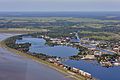
Aerial view of Lake Banter and the Ems-Jade Canal (looking northwest)
· 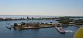
View from the Ferris wheel over the Great Harbour and the Banter Lake in southwest direction; in the background the Jade Bay
· 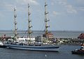
View from the Ferris wheel over the Great Harbour with the Russian sail training ship MIR and the South Beach in southeast direction; in the background the Jade Bay
· 
Maadesiel from the seaside
There are 645 hectares of water areas in the city area, which is 6.2% of the total area. For the most part, these areas consist of the harbour basins of the inner harbour, i.e. Vorhafen, Nordhafen, Ausrüstungshafen, Arsenalhafen, Verbindungshafen, Großer Hafen, Handelshafen, Kohlenhafen and Kanalhafen. The inner harbour is connected to the sea lanes of the North Sea via the largest lock in Germany, the sea lock of the 4th harbour entrance.
In addition, there is the area of the Banter See, a brackish water lake, which belonged to the port area as a western and intermediate harbour until 1945. At the end of the war in 1945, the Allies ordered the harbour basins to be rendered unusable by dams made of rubble from the bombed-out city. The last remaining dam, the Grodendamm, separates Lake Banter from the Great Harbour. An artificial, slightly salty lake was created, which forms one of the large local recreation areas.
The Ems-Jade Canal begins/ends in the city area. It is an artificial waterway that connects Wilhelmshaven with Emden via Sande and Aurich. The length of the Ems-Jade Canal in the city area is 10.5 km. It was of great importance during the expansion of the port facilities, as material such as sand, stones, coal etc. was transported on it. Today, the canal no longer has any economic significance, but is mainly used for tourism.
The only inland river in the urban area is the Maade. With its connected lows, draught and inspection ditches, it primarily serves to drain the lower-lying areas behind the dikes. The river flows into the Jade via a siel near the Rüstersiel district. This Maadesiel is an estuary bailer with a sea lock that ensures the discharge of the river even when regular water discharge is not possible due to tidal conditions on the Jade.
Extension of the urban area
The city area has a surface of 106.91 km². The largest extension in the north-south direction is 15.5 km and in the west-east direction 9.3 km. The city boundary has a total length of 57.8 km, of which 27.3 km are directly on the sea and 30.5 km border other municipalities on land.
Land use
| Land use | Area in ha | Share |
| Residential and open spaces | 1.662 | 15,5 % |
| Commercial space | 1.261 | 11,8 % |
| Traffic areas | 0.971 | 09,1 % |
| Green spaces/sports | 0.464 | 04,3 % |
| Agricultural land | 3.786 | 35,4 % |
| Forest areas/woods | 1.214 | 11,4 % |
| Other use | 1.332 | 12,5 % |
| Total area | 10.6900 | 100,0 %0 |
Around 50 % of the urban area of the "Green City by the Sea" consists of agricultural and forest areas as well as green spaces. The area breakdown is shown in detail in the following table:
Neighboring communities
The municipality of Sande and the town of Schortens border it to the west, and the municipality of Wangerland to the north. All three neighbouring municipalities belong to the district of Friesland. The town borders the North Sea to the east and south. In an easterly direction on the other side of the Jade lies the municipality of Butjadingen. It forms the northern part of the district Wesermarsch. In southern direction on the other side of the Jadebusen one recognizes the surroundings of Dangast, the southernmost North Sea bath at the North Sea coast, in good weather. Dangast belongs to the town of Varel in the district of Friesland.
City breakdown
For statistical purposes, the urban area of Wilhelmshaven is divided into five city areas (South, Central, West, North, East). Each city area consists of several city districts. These are subdivided again into city quarters if they are spatially and structurally coherent areas that are also known by name to the public.
| 1 City area south
2 Central city area
| 3 City area West
4 City area north
| 5 City area east
|
The districts of Fedderwarden and Sengwarden, which were incorporated in 1972, are also localities within the meaning of § 90 of the Lower Saxony Local Government Constitution Act (NKomVG). These localities have their own local council with 13 members, who elect a local mayor as chairman from among their number.
Climate
According to the Köppen climate classification, Central Europe, and thus Wilhelmshaven, is in the Cfb classification for warm temperate rain climates with year-round precipitation. The proximity to the North Sea has a clear effect on the regional weather. Its influence ensures milder winters and cooler summers compared to the interior.
The monthly average temperatures do not drop below freezing point even in winter. The average annual temperature is 8.7 °C. The warmest months are July and August with an average of 16.3 °C and the coldest are January and February with an average of 1.2 and 1.6 °C respectively.
Precipitation is distributed relatively evenly throughout the year, mainly in the form of rain. Snowfall in the winter months is rare. The most precipitation falls in July and November with an average of 83 and 86 millimetres respectively, the least in February with an average of 43 millimetres. The annual precipitation of 831 millimetres is slightly above the average for Germany as a whole.


History
The area of today's town of Wilhelmshaven was originally settled by the Frisians. Until the purchase of land by the Kingdom of Prussia, the two agricultural parishes of Heppens and Neuende, which belonged to the Grand Duchy of Oldenburg, were located in today's core city area.
Jade Treaty 1853 to naming 1869
With the "Jade Treaty" of July 20, 1853, Prussia, which had no North Sea port since the loss of East Frisia at the Congress of Vienna, purchased a 313-hectare area on the Jade Bay from the Grand Duchy of Oldenburg for the establishment of a base for the Prussian Navy. On 23 November 1854, the area was handed over to Prince Adalbert of Prussia, Admiral of the Prussian Navy, under the name Royal Prussian Jade Area. Since then, the history of Wilhelmshaven has been closely linked to the history of the Prussian and German Navy.
The Prussian Admiralty entrusted Privy Councillor Gotthilf Heinrich Ludwig Hagen with the management of the planning for the first German war port on the Jade. Hagen, an engineer and expert in the field of hydraulic engineering, was given leave of absence from his job at the Prussian Ministry of Trade and took over the chairmanship of the Port Construction Commission in the new Prussian Jade area, which was founded on 8 July 1855. After the designs of two internationally known experts did not satisfy him, he submitted his own harbour design to the Prussian Admiralty on 29 May 1856. This design was characterized by great foresight and expertise, because it met the initially still limited requirements of the Prussian Admiralty, but also provided sufficient space for later necessary extensions and additions. Hagen's harbour plan with fortification and town settlement for the naval establishment received approval and authorization by cabinet order of King Frederick William IV of Prussia on June 25, 1856. After completion of the plans, he returned to the Prussian Ministry of Commerce on August 12, 1856. The implementation of the plan took place in the following decade with various changes, most of which resulted from the development of port and shipbuilding, which did not stand still. The plan still determines the layout of the city centre today.
The Jade Treaty of 1853 contained the condition for Prussia that only those civilians were allowed to settle in the naval establishment who were directly involved in the construction of the harbour or in supplying the ships. Hagen's 1856 plan therefore shows only a small town settlement on the south side of the harbour facilities. The settlement was accessed via the Sander Chaussee, which followed the course of today's Bismarckstraße from the Varel-Jever road via Sande, Mariensiel and the Ebkeriege. Jachmannstraße branched off from the Chaussee and led in a southerly direction to a bridge over the harbour canal. Here, starting in 1858, a precisely planned settlement with streets and residential quarters laid out at right angles was established. The first naval buildings were the pilot houses on Manteuffelstraße. From here, year after year, further streets and buildings were laid out to the west, including Roonstraße (today's Rheinstraße). It was intended as the main street for the construction of larger representative buildings and gave the new quarter its name. While the Roonstrasse quarter grew in a carefully planned manner on Prussian territory, the Oldenburg village of Neu-Heppens sprang up wildly to the north of the port facilities. Here, on the border, all those settled who had not been granted permission to do so within the Prussian area due to the condition of the Jade Treaty, among them many innkeepers with their taverns, which enjoyed a lively reception by the dockworkers.
Originally, the port, which was called Hafen Heppens during the construction period, was to be called Zollern am Meer. The name Wilhelmshaven is mentioned for the first time in the document that was laid in the foundation stone of the Elisabethkirche (today's Christus- und Garnisonkirche) on the day of its inauguration (17 June 1869). The draft for this document was made by the harbour construction director Heinrich Wilhelm Goeker. He had written the name with a "v" according to Low German custom (like Bremerhaven and Cuxhaven). In Berlin this supposed spelling mistake was corrected and the "v" was replaced by an "f". When Goeker noticed the change on the day of the founding, he turned to General Albrecht von Roon, who then turned to King Wilhelm I of Prussia. The king then ordered the "v" to be reinstated.
German Empire 1871-1918
After the foundation of the German Empire in 1871, Wilhelmshaven on the North Sea and Kiel on the Baltic Sea became imperial ports of war in accordance with the imperial constitution. In 1873 Wilhelmshaven was granted city rights. Wilhelmshaven belonged as an exclave to the then district of Wittmund in the province of Hanover, which had been Prussian since 1866. On the basis of the Fleet Foundation Plan of 1873, the harbour was greatly expanded in a second construction phase up to 1886. The canal harbour was widened and an outfitting harbour was built on its northern side. In addition, because the original entrance no longer met the requirements, another entrance with a larger lock was built. It is situated further south and thus more favourable to the current. When the new entrance was commissioned, it was given the name "New Entrance"; the first entrance built in 1869 was now the "Old Entrance". In 1888, the completion of the Ems-Jade Canal integrated into the new port facilities could be celebrated.
The population in the Jade area increased steadily due to the construction measures of the port expansion. As the demand for housing in Prussian Wilhelmshaven could not be satisfied quickly enough, ever larger parts of the population settled in the surrounding communities of Heppens and Neuende, which belonged to the Grand Duchy of Oldenburg. New settlements were established, which after the victorious Franco-Prussian War of 1870/1871 were given the names of French towns or landscapes, such as Belfort, Lorraine, Alsace, Sedan or Strasbourg. On November 1, 1879, the independent Oldenburg municipality of Bant was created from the ever-growing village of Belfort.
With the reign of the fleet-loving Emperor Wilhelm II and his naval and foreign policy, Wilhelmshaven's boom increased significantly. The Imperial Navy was now actively involved in the acquisition of colonies in Africa, Asia and Oceania. In line with the growing importance of the Imperial Navy, the leadership structure within the navy also changed. Alfred von Tirpitz, who was appointed head of the Imperial Naval Office in 1898, presented a concept for the construction of a German High Seas Fleet (Tirpitz Plan) and had this concept continued in the long term by the Fleet Laws of 1898 and 1900. The laws were intended to put an end to the constant quarrels in the Reichstag about the strength and financing of the fleet and to make long-term planning possible. For Wilhelmshaven, the Fleet Acts passed by the R e i c h s t a g meant a further expansion of the port and the shipyard as well as a strong increase in the number of ships and personnel.
The Second Fleet Act of 1900 provided for the permanent stationing of a squadron of eight ships of the line in Wilhelmshaven. In addition, at the beginning of the 20th century, the development in warship construction continued to advance. Ever larger battleship units were built. With the capital ships of the Dreadnought class, the British Navy introduced a type of ship that surpassed the previous ships of the line in every respect. If the Imperial Navy wanted to keep up, it had to build such capital ships as well. The significantly larger dimensions of the new ships, however, also required corresponding adjustments to the infrastructure of the Kriegsmarine ports, especially in the shipyards, harbour facilities and locks.
The naval leadership therefore decided on a radical solution for Wilhelmshaven. In the years 1900 to 1909, in the most extensive construction phase to date, the Imperial Dockyard was enlarged, a third entrance was built and the port facilities were extended to the south. By relocating the outer dyke line between the "New Entrance" and Mariensiel, a large part of the mudflat area south of the city was dyked. In the area thus gained, the new harbour basins and facilities of the Great Harbour, the Intermediate Harbour and the Western Harbour were created. In the course of this construction phase, among other things, the Kaiser Wilhelm Bridge was built as a link between the southern part of the city and the new outer dyke line. The third entrance with a 250-metre-long double chamber lock was built in the extension of the Bauhafen canal to the north-east of the oldest entrance. With the commissioning of the third entrance, the names of the entrances were reassigned. It was decided to number the entrances consecutively from west to east. This explains why the first driveway built is now called the 2nd driveway. On 15 October 1909 the new 3rd entrance was inaugurated with the first passage of the two new capital ships SMS Nassau and SMS Westfalen. Both were the first capital ships built at the Kaiserliche Werft Wilhelmshaven.
The population of Wilhelmshaven and the surrounding Oldenburg communities of Heppens, Neuende and Bant continued to rise in the course of these building measures. In the meantime, the housing and social conditions in the Oldenburg communities belonging to the Amt Jever were completely different from those in the rest of the Amt due to the progressing urban development. Therefore, on November 1, 1902, the three municipalities were separated from the Amt Jever and combined to form their own Amt, which was named after the old Frisian Gau Rüstringen. The demand for the foundation of an independent town was initially still rejected, as the government of the Grand Duchy of Oldenburg feared losing influence on the composition of the town administration. Thus, the possible formation of a Social Democratic-led city administration with its own police administration was to be prevented by the predominantly Social Democratic-oriented working class in the municipalities.
The status of rural communities in the Amt Rüstringen did not end for the three communities of Heppens, Neuende and Bant until 1 May 1911, when they were united to form the town of Rüstringen. With a population of around 48,000, it was the largest town in the Grand Duchy of Oldenburg and thus also larger than the residential town of Oldenburg.
Shortly after the start of the First World War in the summer of 1914, the twin town of Wilhelmshaven-Rüstringen and the entire surrounding area were declared a fortress. The status of a fortress was associated with severe restrictions for the population, including the introduction of a compulsory pass, the prohibition of unauthorized persons entering the harbor areas and the dikes, and the prohibition of civilian shipping, including fishing. This was intended to prevent information about fleet activities in the Jade area from becoming known to the wartime enemy.
The Kaiserliche Werft Wilhelmshaven reached its highest staffing level in the course of the First World War. The main task of the shipyard was to ensure the operational readiness of the high seas fleet. In doing so, it was not only responsible for the continuation of planned newbuildings, but primarily for the repair of ships damaged in war-related combat operations. Another task was the conversion of civilian ships into military auxiliary cruisers. By the end of the First World War in 1918, around 20,000 people were working at the Kaiserliche Werft, including many women conscripted for service due to the war.
Despite the preceding arms race, the German Imperial Navy was outnumbered by the British Navy at the beginning of the First World War. The German High Seas Fleet, which was stationed for the most part in Wilhelmshaven or on Schillig-Reede off Wilhelmshaven, therefore behaved rather defensively until January 1916. From 1916 onwards, a more offensive naval warfare was attempted with a policy of pinpricks. By means of targeted provocations, individual British fleet elements were to be lured out of their bases in order to then destroy them with the numerically superior High Seas Fleet, which was waiting in a reception position.
The war port of Wilhelmshaven was often the starting point for undertakings of this kind. One of these, on 31 May 1916, resulted in the Battle of Skagerrak, the largest naval battle of the First World War between the High Seas Fleet of the German Imperial Navy and the Grand Fleet of the British Navy. Both sides claimed victory; but although the Kaiserliche Marine inflicted the significantly heavier losses on the British Navy, the German High Seas Fleet was unable to pose a lasting threat to British naval supremacy. In the end, the naval battles of World War I (including the naval skirmish at Helgoland, the battle on Dogger Bank, and the Battle of Skagerrak) had no decisive impact on the overall course of the Great War. Many of those killed in the naval battles of the First World War were buried in Wilhelmshaven in the new cemetery of honour at Rüstringer Stadtpark, which was established in 1914.
With the fleet order of 24 October 1918, the German Admiralty intended a decisive battle ("honourable demise") with the British Navy in the English Channel shortly before the end of the First World War. Following the order to prepare for the departure of the High Seas Fleet, on 29/30 October 1918, initially isolated mutinies broke out among some of the ship's crews of the fleet lying in the Schillig roadstead off Wilhelmshaven, which led to the Kiel Sailors' Revolt from 3 November 1918. The uprising was the starting point of the November Revolution, which led to the proclamation of the Weimar Republic.
In Wilhelmshaven-Rüstringen on November 6, 1918, after a mass demonstration of more than 20,000 navy personnel, shipyard workers and other civilians, a Workers' and Soldiers' Council was formed, whose executive body was the "21er" Council. Bernhard Kuhnt was appointed chairman of the council. The "21er" Council took power over the fortress towns without opposition from the military station command, and on November 10, 1918, in front of some 100,000 enthusiastic demonstrators in Wilhelmshaven, declared the North Sea station and all surrounding islands and naval sections, as well as the entire Oldenburg region belonging to it, to be the Socialist Republic of Oldenburg/East Frisia and the deposition of the Grand Duke of Oldenburg. Under the impression of the demonstrations and the pressure of the broad majority of the members of the Landtag in Oldenburg, the Grand Duke Friedrich August abdicated on 11 November 1918 and declared his renunciation of the throne. The Free State of Oldenburg was then declared on the territory of the Grand Duchy of Oldenburg. A state directorate was formed as a provisional government, which included Paul Hug, a member of the state parliament from Rüstringen, and Kuhnt. Kuhnt became president of the new Free State of Oldenburg.
Weimar Republic 1919-1933
The candidate line-up for the elections to the constituent National Assembly on 19 January 1919 led to insurmountable antagonisms within the SPD in Wilhelmshaven-Rüstringen. When the Rüstringen deputy Hug achieved a better place on the list than Kuhnt, the "21er" council decided to run in the election to the National Assembly with its own list for the USPD, at the head of which Kuhnt was placed. Despite the many USPD supporters among the approximately 100,000 marines still in Wilhelmshaven-Rüstringen at the end of 1918, large sections of the population did not vote for the radical USPD, but for the more moderate SPD. While Hug was elected to the National Assembly, Kuhnt did not receive the required number of votes.
After the defeat of the USPD in the elections, the communist KPD attempted to seize power through a coup. On 27 January 1919 their supporters occupied the railway station, the post office, the telephone exchange, the Reichsbankstelle and the town halls of the twin town of Wilhelmshaven-Rüstringen. In the Reichsbankstelle the putschists looted over 7 million marks, including the entire gold stock of the branch. On the same day regular troops of the naval garrison were able to restore constitutional order. The putschists then retreated to the thousand-man barracks in Wilhelmshaven and entrenched themselves. Unwilling to surrender, they were forced to surrender by artillery fire. Eight were killed and 46 wounded. In the course of this action, the "21" Council was forced to relinquish military control. It subsequently became known that its members had been informed of the planning of the coup, but nevertheless had not intervened. Kuhnt was thereupon suspended by the Ministry of Defence in Berlin, and on 29 January 1919 was relieved of his office as President of the Free State of Oldenburg.
On April 1, 1919, Wilhelmshaven became an independent town, and two months later Rüstringen received the status of "Stadt I. Klasse". Klasse".
The requirements for disarmament and delivery of a large part of the provisional Imperial Navy, which already took effect with the armistice agreement of November 11, 1918, and the conditions for the reduction of the Navy in the Versailles Peace Treaty on June 28, 1919, hit the economy of the Jade towns hard in the post-war years. Due to the one-sided focus on the Kaiserliche Werft and the navy, a large part of the population lost its livelihood. The Kaiserliche Werft, now renamed Reichsmarinewerft, continued to operate on a significantly reduced scale, but was initially not allowed to build any new ships due to the requirements of the Treaty of Versailles. It was not until early 1925 that the launch of the light cruiser Emden, the first new ship for the new Reichsmarine, could be celebrated.
The efforts of the two cities to convert to peacetime production were manifold, but for a variety of reasons were repeatedly marked by failure. The attempt to establish a deep-sea fishing fleet in Wilhelmshaven began promisingly, but failed again as early as 1922, when the demand for fish collapsed as a result of the lifting of the meat rationing that had still existed until then. The need for scrapping capacity also led to a boom in this sector only in the short term. Wilhelmshaven-Rüstringen became the largest scrap yard in Europe for a few years with eleven scrapping yards. The introduction of the Rentenmark in late autumn 1923 put an abrupt end to this. Almost all the newly established companies had to close down. From 1925 onwards, many unemployed people could be employed for a short time through emergency work in the construction sector, i.e. job creation measures. These measures enabled construction projects such as the embankment of the Rüstersieler Außengroden, the construction of the Rüstringer town hall, the extension of the Rüstringer Stadtpark and other urban development projects to be realised by 1928.
In the second half of the 1920s, the town tried to create another civilian mainstay by developing tourism. With a great deal of advertising ("the green town by the sea"), an attempt was made to establish Wilhelmshaven-Rüstringen as a modern North Sea resort for the middle classes. A beach complex was created on the south beach with five brick beach houses used as hotels and a beach hall, which still appear today as a closed ensemble. The buildings cost around 950,000 Reichsmark and were inaugurated on 16 June 1928. The success proved the planners right. In 1928, 10,543 guests were counted, a figure that was increased to around 13,000 by 1932, thus contributing to a temporary improvement in the town's economic situation.
National Socialism 1933-1945
After the seizure of power in January 1933, the National Socialists systematically began arming the Reichswehr and Reichsmarine. The German-British naval agreement of 1935 permitted the renamed Kriegsmarine to significantly expand its fleet. As a result, the Jade towns experienced a renewed economic upswing, as the fleet policy that had been introduced required the further expansion of the port and shipyard facilities in Wilhelmshaven. The planning of a northern extension of the harbour with a 4th entrance, which dated back to 1917, was resumed; construction of the new entrance began as early as 1936. Like the 3rd entrance, this had two lock chambers, but they were built at a greater distance from each other. This was done to reduce the risk of simultaneous shutdown due to damage to the middle wall during air raids. The dimensions of the new lock chambers (390 meters long, 60 meters wide) far exceeded the dimensions of the capital ships of the Bismarck class. The 4th entrance was commissioned on 7 November 1942 with the lockage of the light cruiser Emden by the Eastern Chamber and christened the Raeder Lock. Due to the war, the entrance was only partially completed; only the east chamber could be used until the end of the war.
By the Greater Hamburg Act of 1937, Wilhelmshaven, which was in the Prussian province of Hanover, and the Oldenburg village of Rüstringen were united to form the new town of Wilhelmshaven on 1 April 1937 and this was assigned to the Free State of Oldenburg. At the same time, the neighbouring village of Rüstersiel was incorporated. A further territorial reform on 1 June 1938 extended the town area to include parts of the neighbouring municipality of Kniphausen, which had been formed in 1933. Plans were drawn up on the drawing board that envisaged an expansion of the city to up to 500,000 inhabitants. Decentralized settlements on the outskirts of the city were built to accommodate the steadily growing population. In the course of these building measures, Altengroden, Neuengroden, Fedderwardergroden and Voslapp were created. In 1940, the population reached its historic high of 133,041.
During the Second World War, the building fabric of the city was extensively destroyed by more than 100 air raids, 16 of which were major.
On 28 February 1941, two trains collided near Wilhelmshaven. 21 people died, another 28 were injured.
The first air raid on Wilhelmshaven took place as early as September 4, 1939, the last on March 30, 1945. On January 27, 1943, the United States Army Air Forces (USAAF) directed their first daylight raid on a target in the German Reich against Wilhelmshaven. Of the 55 four-engine bombers, 8 were shot down. Probably the heaviest air raid destroyed the old Wilhelmshaven on 15 October 1944. At the end of the war, 60% of the residential area lay in ruins. The comparatively low number of air-raid deaths (435) was due to the many air-raid shelters that had been built all over the city, partly as a result of the Führer's immediate action programme. Most of the air war dead were buried in row graves in the municipal cemetery of Aldenburg. There, a memorial has commemorated the town's civilian bombing victims since 1978.
During the National Socialist era, persecution, coercion and oppression also took place in Wilhelmshaven. The Neuengamme concentration camp had maintained a subcamp at Alter Banter Weg since September 1944. The inmates, mainly French, were forced to perform forced labour and were deployed, for example, at the Kriegsmarine shipyard and in bomb disposal in the city. 1,125 men were crammed into four barracks under adverse conditions; at least 234 of them did not survive the inhumane conditions of internment. Today, part of the camp grounds is a concentration camp memorial. In April 1945, the SS disbanded the Wilhelmshaven concentration camp. The prisoners were to be taken by rail to the main camp in Hamburg-Neuengamme. At an intermediate stop at Lüneburg station, 256 men were killed when an Allied air raid also hit the train. The leader of the transport, the then 36-year-old Danish SS man Gustav Alfred Jepsen, was sentenced to death in 1947 for the crimes he had committed in the Wilhelmshaven concentration camp and executed in Hameln prison.
About 1000 Dutchmen were interned in the Schwarzer Weg camp in 1945.
See also: "2nd Marine Flak Regiment - Wilhelmshaven" in the article: Marine-Flak
Occupation period 1945-1949
On 6 May 1945, the city was occupied by the 1st Polish Armoured Division under the command of Stanisław Maczek, which had been established in Scotland. With the German surrender on May 8, 1945, the period of occupation in the British occupation zone began for Wilhelmshaven. The initially announced most extensive elimination of Wilhelmshaven as a war port city was averted. What remained was the dismantling and shipment of the entire inventory of the Kriegsmarinewerft and the destruction of all military installations. In the course of Operation "Bailiff", all shipyard and quay facilities, docks and locks, including the new 4th entrance, were blown up by the spring of 1950. Only the second oldest and smallest entrance, the 1st entrance, was spared from destruction.
In the course of Operation Oasis, about 1550 European Jews were housed in the Sengwarden naval camp from November 1947 to August 1948 on the instructions of the British military government. These people had attempted to enter Palestine (then a British League of Nations mandate) illegally on the ship Exodus; the British Mandate administration brought them back to Europe.
Federal Republic 1949-1999
As a result of the dismantling and destruction of almost all shipyard facilities, unemployment initially rose dramatically. In June 1952, the unemployment rate in the Wilhelmshaven employment office district was 24.3% (by comparison: federal government 7.6%; state of Lower Saxony 12.3%). Deprived of its port industry infrastructure, the town had to reorient itself and seek other economic foundations. This was achieved with the relocation of a number of medium-sized companies, such as the crane manufacturer Krupp-Ardelt, the worsted spinning and weaving mill KSW and the commercial vehicle manufacturer Nordwestdeutscher Fahrzeugbau. These companies took advantage of the vacant real estate of the former navy and the skilled labour supply, which consisted mainly of workers from the former Kriegsmarinewerft. Likewise, the Olympia-Werke, which settled in Roffhausen, now part of the town of Schortens, in the district of Friesland, contributed to an economic upswing through the workers employed there.
Efforts to settle universities and scientific institutes such as the College of Labour, Politics and Economics in Rüstersiel, the College of Education for Trade Teachers, the College of Education for Agricultural Teachers, the Max Planck Institute for Cell Biology, the Lower Saxony State Institute for Marsh and Worm Research, now the Lower Saxony Institute for Historical Coastal Research, and the Institute for Bird Research - Vogelwarte Helgoland were also successful. From the early 1960s, Wilhelmshaven lost most of these institutions again. Only the two state institutes, the Institute for Bird Research and the Institute for Historical Coastal Research, could be kept in Wilhelmshaven. Another new educational institution in Wilhelmshaven was the "Prince Rupert School". Founded in 1947, this English boarding school for the children of British occupation forces was housed on the site of the former submarine barracks directly on Lake Banter. It existed until 1972 and at its peak had at times more than 700 pupils. The English boarding school children with their typical British school uniforms dominated the Wilhelmshaven townscape for many years.
With the German rearmament and the establishment of the Bundesmarine, Wilhelmshaven became a naval port again in 1956. On 2 January 1956, the first volunteers of the new Bundesmarine began their service in Wilhelmshaven, and on 6 June 1956, the first ships, minesweepers returned by the USA from the former German Kriegsmarine, arrived. The new defence concept also provided for the establishment of a naval arsenal for the maintenance and repair of the new ship units. In 1957, planning began on the site of the former Kriegsmarinewerft. Within 15 years, one of Wilhelmshaven's largest employers was created on the rubble site. Parallel to the construction of the naval arsenal, planning began for the reconstruction of the blown-up 4th entrance. The reconstruction included the new construction of a tide-independent outer harbour with a naval base. In 1956, the first preliminary work began. On 4 October 1964, the new 4th entrance became operational. The naval base built in the outer harbour Heppenser Groden was inaugurated on 9 August 1968.
In November 1956, Nord-West-Oelleitung GmbH (NWO) was founded in Wilhelmshaven. The aim of the company is to build and operate the first long-distance mineral oil pipeline in Europe in order to ensure the supply of raw materials to several mineral oil refineries in the Emsland and Rhine-Ruhr regions. NWO's operating facilities were built on the Heppenser Groden, which included a tanker discharge bridge on the deep fairway of the Jade, an intermediate tank farm on the Heppenser Groden and a 28-inch long-distance mineral oil pipeline with all the necessary technical facilities. The new company started operations in November 1958. On 29 November 1958 the first crude oil tankers called at Wilhelmshaven and discharged their cargo. Since then, the newly built oil port of Wilhelmshaven has developed into the largest mineral oil import port in the Federal Republic of Germany.
On 1 July 1972, the municipality of Sengwarden was incorporated into Wilhelmshaven with its associated districts and residential areas, including Fedderwarden. This meant that the urban area of Wilhelmshaven reached its current size.
In the years 1970 to 1981, further large-scale industrial enterprises were established on the newly reclaimed Groden areas at the deep Jade fairway. After Nord-West-Oelleitung GmbH in Heppenser Groden, a chlor-alkali electrolysis plant (Alusuisse Atlantik GmbH) and a power station (Nordwestdeutsche Kraftwerke AG) were built in Rüstersieler Groden, as well as an oil refinery of Mobil Oil AG and a chemical plant of Imperial Chemical Industries for the production of VCM and PVC in Voslapper Groden. The economic development, which had been positive for Wilhelmshaven until then, came to an end with the oil crisis of 1979. The economic recession that followed the oil crisis and the associated decline in the consumption of mineral oil products finally led to the closure of the refinery on 1 April 1985. Only after its sale to Beta Raffinerie Wilhelmshaven GmbH was the refinery put back into operation in 1991.
From the mid-1980s onwards, bad economic news from AEG Olympia AG, the largest industrial employer in the Wilhelmshaven/Friesland region, began to accumulate. After years of losses at the office machine manufacturer, the corporate headquarters of the parent companies AEG and Daimler-Benz decided in October 1991 to withdraw from office communications and close the site with its workforce of around 3,600 employees. Under the slogan "Olympia - the heart of the region must go on living", the next few months saw the Olympia employees take industrial action to save their jobs, a campaign which attracted nationwide attention. Actions in Wilhelmshaven, Frankfurt and Stuttgart reminded them of the responsibility of the Daimler-Benz group and built up public pressure to create replacement jobs in the Wilhelmshaven/Friesland region. Nevertheless, it was not possible to prevent the closure of the Roffhausen plant at the end of 1992. As a positive result of the industrial action, a concept was developed for a TCN (Technologie Centrum Nordwest), which provided for the spin-off and continuation of parts of Olympia's operations as independent companies and the establishment of new companies on the TCN site. The concept received support from the government of Lower Saxony, the parent company Daimler-Benz, the district of Friesland, the town of Schortens and employee representatives. At the beginning of 1993, the TCN had 14 companies with around 750 employees. This positive development continued, so that by the end of 2015, with more than 3,000 employees in a total of 60 companies, the number of employees who used to work on the site at the Olympia factories had almost been reached again.
Construction work on the Nordseepassage began in December 1994. On the site of the old Wilhelmshaven railway station and station forecourt, the largest shopping centre in Wilhelmshaven was built, covering 34,000 m². Initially called the "Bahnhofszentrum", the DM 150 million construction project not only provides retail space, but also houses the new Wilhelmshaven railway station and the Wilhelmshaven bus station as well as two multi-storey car parks. After a construction period of around three years, the Nordseepassage was inaugurated on 4 September 1997.
Federal Republic 2000 until today
From 1 June 2000 to 31 October 2000, the "Expo by the Sea" took place in Wilhelmshaven as one of the official Expo 2000 projects for the World Exhibition in Hanover. For this purpose, Sparkasse Wilhelmshaven brought the highly regarded German contribution to the world exhibition Expo 98 in Lisbon to Wilhelmshaven. Its content was revised and it found a new home as the virtual underwater research station OCEANIS directly at the "Great Harbour". The research station showed the world of the deep sea from a depth of 100 metres. By the end of 2007, over one million visitors had visited the research station. At the end of 2009 the OCEANIS was closed and reopened in 2010 as "North Sea Worlds 5D in Oceanis". In addition to parts of the old Oceanis exhibition, the focus was now on 3D cinema films with additional effects. In July 2011, however, the company had to file for insolvency and close.
After 16 years of planning and four and a half years of construction, the JadeWeserPort was officially opened on 21 September 2012. The container port washed up in the north of Wilhelmshaven was one of the largest infrastructure projects in northern Germany in recent decades. The two federal states of Lower Saxony and Bremen and the container port operator Eurogate invested around one billion euros.
The Kaiser Wilhelm Bridge was renovated from September 2010 to September 2013. The steel structure was repaired and, among other things, it received a new coating as well as new pavements for the carriageways and the footpaths. The railing was restored according to historical models. In addition, the bridge was equipped with a new lighting concept to highlight it as a landmark of the city. In the vicinity of the bridge, the bridge houses were fundamentally renovated and a new staircase was built as access to the north wing.
From December 2012, at the suggestion of the Lord Mayor of Wilhelmshaven Andreas Wagner and the District Administrator of Friesland Sven Ambrosy, a controversial debate developed about more intensive cooperation between the two municipalities. The background to this was, among other things, the Future Programme of the state of Lower Saxony, which takes over 75% of the short-term debts of the municipalities involved in the merger in the case of territorial reforms. In the case of Wilhelmshaven-Friesland, the debt relief aid would have amounted to 35 million euros for Wilhelmshaven and 9 million euros for Friesland. In order to clarify the possible savings, an expert opinion was commissioned from the independent Kommunale Gemeinschaftsstelle für Verwaltungsmanagement (KGSt) to examine the financial effects of a possible merger of the city of Wilhelmshaven and the district of Friesland. The report was published in November 2013 and recommended that the city of Wilhelmshaven be incorporated into the district of Friesland. Wilhelmshaven would therefore have had to give up its freedom of the district. However, the political leaders could not decide on this solution. In December 2013, both municipalities rejected the incorporation in their respective bodies.
In accordance with a resolution passed by the city council in October 2014, the previous Catholic-run St. Willehad Hospital was taken over by the city on 7 November 2014 and affiliated with the municipal Reinhard-Nieter Hospital under the new joint name Klinikum Wilhelmshaven. It is to be expanded by a new building in the next few years.
In April 2015, Bismarckplatz received a new Bismarck monument on private initiative. The donation was highly controversial among the public. However, the city council approved the project by a narrow majority.
The Day of Lower Saxony took place in Wilhelmshaven from 14 to 16 June 2019. Embedded in the presentations and events of the Lower Saxony Day was the ceremony celebrating the 150th anniversary of the city of Wilhelmshaven.
| Tabular representation of the development of Wilhelmshaven | ||||||
| Year | Wilhelmshaven | Heppens | New ending | Bant | Sengwarden | |
| 1869 | Naming of | Heppens | New end1 | - – | Sengwarden | |
| 1873 | Wilhelmshaven becomes | |||||
| 1879 | Wilhelmshaven | foundation of Bant | ||||
| 1911 | Merger into the city of Rüstringen | |||||
| 1937 | Association to the new city of Wilhelmshaven | |||||
| 1938 | Parts of the municipality of Kniphausen to Wilhelmshaven | |||||
| 1948 | Wilhelmshaven | Fedderwarden to | ||||
| 1972 | Sengwarden zu Wilhelmshaven | |||||
1 Neuende municipality with the Rüstersiel residential area
Population development
→ Main article: Population development of Wilhelmshaven
In 1853, only 335 people lived in the Royal Prussian Jade area. With the expansion of the port, the population grew to over 10,000 by 1875. By 1895, this number had doubled to 20,000. The incorporation of Rüstringen (48,562 inhabitants in 1933) on 1 April 1937 increased the population to 91,000. In 1938, the population of Wilhelmshaven exceeded 100,000, making it a major city. In 1940, the population reached its historic high of 133,041. As a result of the destruction in the Second World War, this fell by a third to 89,000 in December 1945.
In the 1970s, the population was still over 100,000. It then fell sharply as a result of several company closures, in particular the demise of the Olympia typewriter factory, and because of the downsizing of the Bundeswehr base. On 30 June 2006, the "official population" for Wilhelmshaven was 83,238 according to an update of the Lower Saxony State Office for Statistics (only main residences and after comparison with the other state offices). In 2007, Wilhelmshaven was the most shrinking independent city in Lower Saxony and was particularly affected by the consequences of demographic change. According to a population forecast by the Lower Saxony development bank NBank in May 2015, the regional centre of Wilhelmshaven was expected to lose around 20% of its population by 2035 and could slip below 63,000 inhabitants. In addition to Wilhelmshaven, the cities of Göttingen, Hildesheim and Salzgitter, the Leine and Weserbergland regions as well as the western Harz, Lüchow-Dannenberg and the area around the Jadebusen are also most affected.
On 31 May 2013, the State Office for Statistics and Communication Technology of Lower Saxony published the results of the 2011 census for Lower Saxony. According to this, Wilhelmshaven had 76,926 inhabitants on the reporting date of 31 December 2011. This is a minus of 5.1% compared to the previous official population of 81,020 as of 31 December 2011, which was based on an update of the 1987 census. Wilhelmshaven was thus the city in Lower Saxony most affected by the recalculation after Osnabrück (-6.4 %).
The high number of people arriving from crisis areas since the beginning of the so-called refugee crisis in 2015 presented the city of Wilhelmshaven with major challenges in terms of the social and economic integration of refugees. For the first time since 2013, the number of inhabitants increased from 78,237 in 2014 to 79,218 in 2018. For Wilhelmshaven, the state of Lower Saxony therefore issued an immigration ban for recognised refugees in November 2017. The so-called location-adjusted residence restriction is a "temporary immigration restriction" and is intended to support municipalities that have an exceptionally high influx of recognised refugees relative to their resident population. The immigration restriction is intended to reduce problems with integration.
Nicknames
Wilhelmshaven is often called Schlicktau or Schlicktown by locals and initiated out-of-towners. The name Schlicktau originates from the imperial navy, who combined an allusion to both the silt of the Wilhelmshaven mudflats and the word end of the capital Tsingtau of the former leased territory of Kiautschou in China into one word. In Tsingtau mainly Wilhelmshaven marines were stationed during the colonial period. Already the well-known navy writer Gorch Fock, who was in Wilhelmshaven with the ship SMS Wiesbaden in April 1916, used the name Schlicktau in his diary. The term Schlicktown, which is used quite frequently today, only came into being in the years after the Second World War, when, due to the Bundeswehr's membership in NATO, English also became the predominant language in the navy among the alliance countries. Due to these connections regarding the second name, the city of Wilhelmshaven established contacts with the port city of Tsingtau, today's Qingdao, in the 1990s. A port partnership between the two cities has officially existed since 1992.


Related articles
Author
AlegsaOnline.com Wilhelmshaven: North Sea Port City and German Naval Base Leandro Alegsa
URL: https://en.alegsaonline.com/art/108135
Sources
- destatis.de : "Alle politisch selbständigen Gemeinden mit ausgewählten Merkmalen am 31.12.2018 (4. Quartal)" · web.archive.org
- destatis.de : destatis.de/DE/ZahlenFakten/LaenderRegionen/Regionales/Gemeindeverzeichnis/Administrativ/…
- www1.nls.niedersachsen.de : Landesbetrieb für Statistik und Kommunikationstechnologie Niedersachsen, 102 Bevölkerung - Basis Zensus 2011, Stand 31. Dezember 2015 (Tabelle K1020014) · archive.is
- cncd.fr : cncd.fr
- commons.wikimedia.org : Wilhelmshaven