Westfjords (Vestfirðir): Peninsula and Region in Northwest Iceland
Remote, mountainous peninsula in northwest Iceland known for deep fjords, sparse settlements, dramatic cliffs, rich birdlife, cold currents and a long maritime history.
Overview
The Westfjords (Icelandic: Vestfirðir) are a large, sparsely populated peninsula and administrative region in northwest Iceland. The coastline is deeply indented by a series of long, narrow inlets and sheltered bays that together form one of the country’s most rugged seascapes. The peninsula faces the Arctic-influenced waters of the Denmark Strait and looks across toward the east coast of Greenland.
Image gallery
10 Images


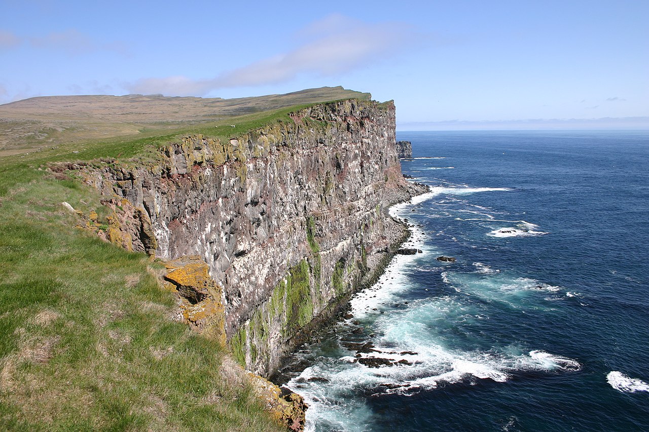

Geography and landscape
The defining feature of the area is its fjord-dominated shoreline: steep mountains drop to the sea around numerous arms and coves, creating complex terrain and isolated communities. These coastal indentations are often referred to simply as fjords or fiords (fjords), and the resulting labyrinth of valleys and peninsulas shapes local travel and settlement patterns. The interior is thinly populated, with plateaus and highland ridges between the arms.
Climate and ecology
The Westfjords are among the coolest parts of Iceland, a consequence of cold ocean currents such as the East Greenland Current carrying icy water southward along the coast. The climate is maritime and changeable: winters are cold and windy, and sea ice and fog can appear near shore in some winters. These conditions support rich marine life and large seabird colonies; cliffs and coastal stacks provide breeding habitat for puffins, guillemots and other species. Terrestrial wildlife includes Arctic foxes and coastal seals, while the surrounding seas sustain productive fisheries.
History and human geography
People have lived around these fjords for centuries, relying on fishing, small-scale farming and sealing. The largest town and regional service center is Ísafjörður, which functions as an administrative, cultural and transport hub for the area. The region’s isolation shaped distinctive local cultures and traditions. A notable historical episode occurred in the early 17th century when clashes with Basque whalers led to violence; a long-standing legal anomaly originating from that period was formally removed from the statutes in the 21st century. For traditional and scholarly perspectives see sources linked locally: peninsula and region.
Transport, economy and tourism
Because of the many fjords and steep terrain, overland travel is indirect and historically difficult. Modern infrastructure relies on a mix of coastal roads, ferry connections and a number of tunnels that shorten routes between communities; however, some drives remain long and subject to winter closures. The economy has traditionally centered on fishing and fish processing, but tourism has grown since the late 20th century, attracted by dramatic waterfalls (such as Dynjandi), the sea cliffs at Látrabjarg, remote nature reserves like Hornstrandir, and opportunities for birdwatching, hiking and experiencing rural Icelandic life.
Notable features and distinctions
- Extensive fjord coastline that creates many isolated settlements and scenic drives.
- Important seabird colonies and rugged cliffs popular with nature tourism.
- Maritime climate strongly influenced by cold ocean currents, making it one of Iceland’s chillier regions.
- A cultural history shaped by fishing, seafaring and long periods of isolation—modern connections continue to evolve.
For further reading and maps consult regional guides and local institutions: Icelandic sources, regional overviews at maritime pages, and conservation or tourism pages accessible via national and local resources.
Questions and answers
Q: What is the name of the large peninsula and region in northern Iceland?
A: The Westfjords or West Fjords (Icelandic: Vestfirðir).
Q: Where is the Westfjords located?
A: It is next to the Denmark Strait and faces the east coast of Greenland.
Q: What makes travelling by land difficult in this area?
A: The Westfjords have a lot of mountains and fjords around the coast, making it complex to navigate by road.
Q: What is the largest settlement in this region?
A: The largest settlement is Ísafjörður, with a population of 4,000 people.
Q: Why are temperatures generally colder here than other parts of Iceland?
A: Because of the East Greenland Current, the Westfjords are generally the coldest area in Iceland.
Q: What event occurred in 1615 that caused a law to be passed?
A: In 1615, 32 shipwrecked Basque whalers were killed by locals which caused the government to pass a law allowing for murder of any Basque person seen in the Westfjords.
Q: When was this law ended?
A: This law was ended in May 2015.
Related articles
Author
AlegsaOnline.com Westfjords (Vestfirðir): Peninsula and Region in Northwest Iceland Leandro Alegsa
URL: https://en.alegsaonline.com/art/107557