Weser (river in northwestern Germany)
The Weser is a major river in northwestern Germany, formed by the Fulda and Werra. It flows north through Lower Saxony and Bremen to the North Sea and has long been important for navigation, industry, and ecology.
Overview
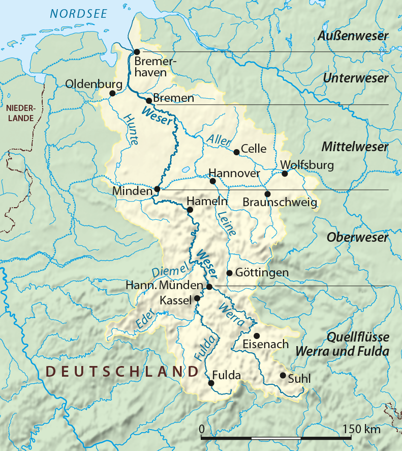
The Weser is a principal river of northwestern Germany, created at Hannoversch Münden by the joining of the Fulda and Werra. From that confluence it runs generally northward through lowland landscapes and the city of Bremen, before reaching the North Sea. Its course within Germany is commonly given as about 440 km, and if measured including the Werra its full length is often cited as around 730 km.
Image gallery
10 Images


Course and characteristics
The river begins in a hilly area where the two headstreams meet and then travels through valleys and plains. Along its route it receives several tributaries and passes a sequence of towns that reflect its long role as a transportation corridor. The lower reaches form a tidal estuary that widens toward the sea and supports both fresh and brackish-water habitats.
Human use and navigation
The Weser has been adapted for shipping and regional commerce for centuries. Locks, weirs and dredging maintain navigable channels for barges and, in the estuary, for ocean-going vessels visiting ports and industrial sites. Major urban centers and ports on or near the river have relied on it for trade, fisheries and employment.
Ecology and management
Riparian and estuarine zones along the Weser host diverse plant and animal communities. Conservation efforts, flood protection measures and water-quality programs aim to balance human uses with habitat protection. Engineering works have shaped the river’s flow, and contemporary management emphasizes ecological restoration where feasible.
Notable places and cultural role
- Towns and cities on the Weser corridor include historical and cultural centers that grew with river trade.
- The river has long connected inland regions with maritime routes, influencing settlement patterns and industry.
- Its estuary and port areas remain important gateways to the North Sea for the region.
The Weser therefore combines natural riverine functions with significant economic and cultural importance for northwestern Germany, serving as both a landscape feature and a working waterway.

Name origin
The Latinized form Visurgis in Tacitus suggests Germanic *Visuri with the genitive *Visurjos. This name, like that of the French Vézère (tributary of the Dordogne) and the Vesdre in Belgium (tributary of the Ourthe, also attested as Wesere in 915, and called Weser in eastern Belgium), ultimately comes from the Indo-European root *u̯eis- "to flow, to dissolve", which is attested in almost all Indo-European language groups - especially in Celtic, Germanic, Romance and Baltic. Other river names of the same origin as Weser/Werra are La Vis in France, Wear (from *Visuria) in northern England, Vesouze (tributary of the Meurthe), Wiesaz in Württemberg, Vesonze in Wallis, Visance in France, Dep. Orne, Bisenzio in Etruria, Besançon in France, Viešintà in Lithuania, Visance in Norway and Sweden, and the Vistula, today Wisła "Vistula".
From the 8th century on, for the Weser, as well as for the Werra, Old High German name forms, such as Wesera, Wisura, Wisera, Wisora, Wisara are handed down, also with appended -aha - "flowing water" - Wiseraha or Wisuraha. As late as 1075 Adam of Bremen expressly said: "The most excellent rivers of Saxony are the Elbe, the Saale, and the Wisara, which is now also called Wissula or Wirraha." It can therefore be assumed that the Weser and Werra were one and the same name in ancient times, although in the course of time regional linguistic differentiation led to a conceptual separation of the upper course from the rest of the river by aligning /sr/ to /rr/. This assumption is supported by the fact that the border between the Low and High German language areas (the Benrath line) ran almost exactly at Hann. Münden (more precisely through its district Hedemünden), whereby the High German form Wirra developed into Werra. The Low German form de Wersern or de Werser still contains both middle consonants. It was not until New High German that the names Werra and Weser were clearly separated and used to designate the upper and lower reaches of the same river.
History
Source Flows
The Werra, flowing in from the Thuringian Forest, and the Fulda, coming from the Rhön, unite between the south-eastern Kaufunger Forest, the western Reinhardswald and the northern Bramwald to form the Weser in Hann. Münden at 116.5 m above sea level. On the river island Tanzwerder at the confluence stands since 1899 the Weser stone with the inscription:
"Where Werra and Fulda kiss each otherThey
must atone for their names,
And here by this kissGerman
to the sea the Weser River
is born.
Hann. Münden, d. 31. July 1899"
The Werra has an average water flow of 51.0 m³/s and a length of about 300 km. The Fulda, with an average water flow of 66.9 m³/s, is more watery and would therefore be considered hydrologically as the upper reaches of the Weser. At 221 km, it is shorter than the Werra, which drains a long, narrow catchment area. The Fulda, in turn, would hydrologically be a tributary of the Eder, which brings more water with it at the confluence than the Fulda above.
Historically, however, the Werra and Weser had the same name and the Fulda was considered a tributary.
Upper Weser
In Hann. Münden is the zero point of the inland waterway mileage of the Weser. Its water level is 116.5 m above sea level. As the Upper Weser, it flows through the Weserbergland in the Upper Weser Valley to Porta Westfalica. The slopes of the Upper Weser Valley are predominantly forested. In many places red sandstone was and is quarried, from which also numerous historical buildings were built. Many villages are characterised by half-timbered houses with a gradual transition from Hessian to Lower Saxonian-Westphalian architecture. From Hann. Münden to Bad Karlshafen the Weser is the border between Lower Saxony and Hesse for a long distance, from there to behind Holzminden it is partly the border between Lower Saxony and North Rhine-Westphalia. Afterwards it flows through Lower Saxony, behind Rinteln then through North Rhine-Westphalia.
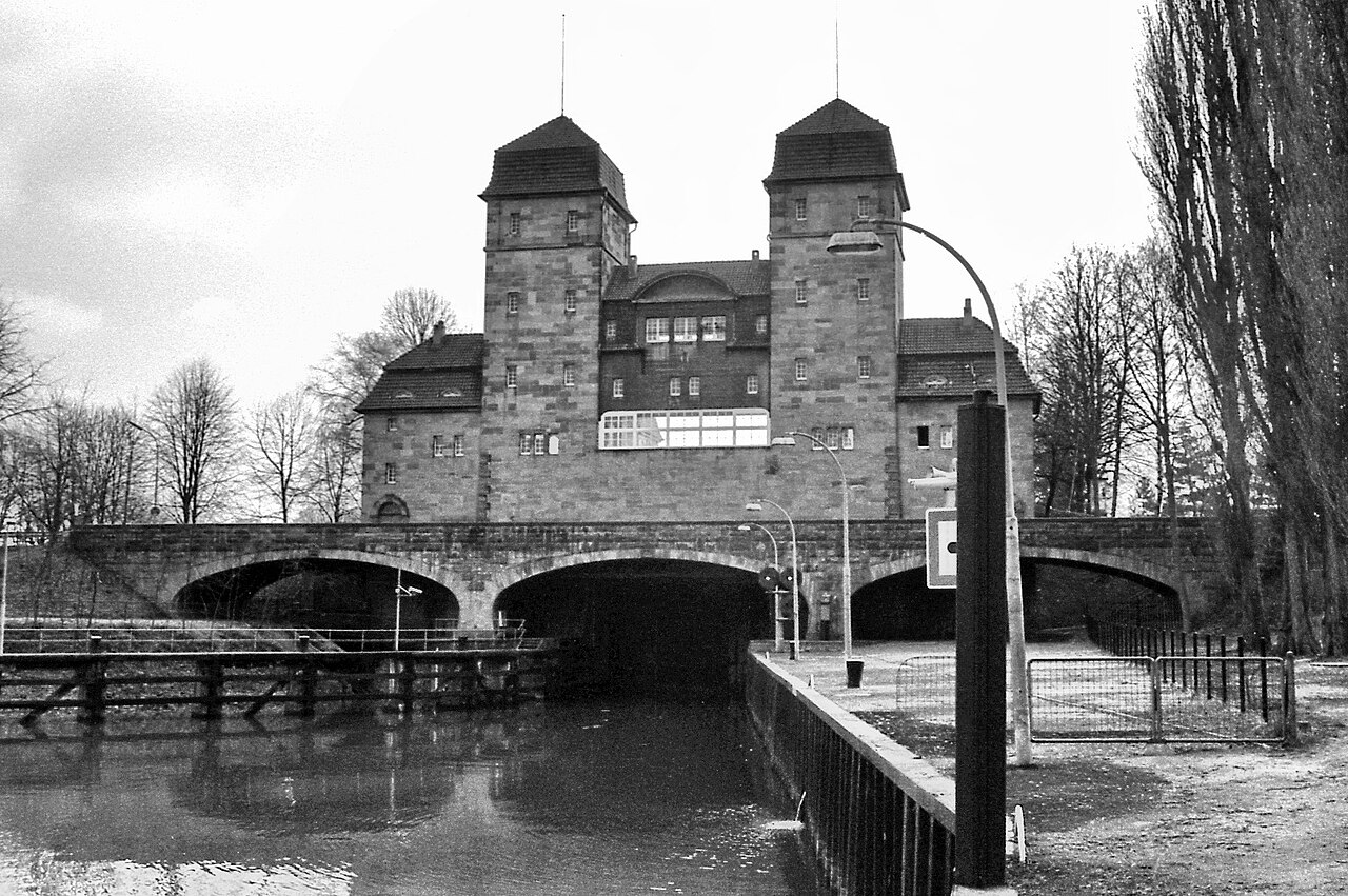
The Upper Weser breakthrough valley begins near Hann. Münden, initially leading northwards between Reinhardswald and Bramwald, it bends sharply to the west at the Kahlberg before the Solling. Between Reinhardswald and Solling the Weser has dug itself up to 300 m deep. It passes Bad Karlshafen and the Hannoversche Klippen and bends to the north at the south-western edge of the Solling. The valley widens here, for example near Höxter, Holzminden and between Hameln and Rinteln, but in between there are always narrow sections with steep slopes, for example the "Rühler Schweiz". Between Holzminden and Bodenwerder the Weser passes the Burgberg and Vogler mountain ranges, which, like the Solling, belong to the Solling-Vogler Nature Park. North of Bodenwerder the Weser crosses the nature park Weserbergland Schaumburg-Hameln. The only barrage of the Upper Weser is located in Hameln. It is also the oldest barrage of the entire river, originating from a medieval mill dam. Below Hameln, the course of the river turns increasingly westwards, then northwards again at Vlotho. After taking in the Werre, the Weser enters the North German Lowlands through the approximately 200 m deep Weser breakthrough at Porta Westfalica between the Weser Mountains and the Wiehen Mountains (Weser km 199; water level about 40 m high). Thereby it cuts through a small eastern part of the nature park Nördlicher Teutoburger Wald-Wiehengebirge (Northern Teutoburg Forest-Wiehen Mountains), which reaches from the distant Teutoburg Forest over the Wiehen Mountains into the Weser Mountains shortly before Bückeburg.
Midweser
At the northern edge of Minden the Weser is crossed by the Mittellandkanal. From this waterway junction onwards, it is referred to as the Middle Weser according to the definition of the Waterways and Shipping Authority. From a geographical point of view, the Porta Westfalica is sometimes mentioned as the border between the Upper and Middle Weser. Up to Schlüsselburg it flows through North Rhine-Westphalia, then from Stolzenau through Lower Saxony. Here in the North German lowlands one also speaks of the Weser lowlands. Up to Hoya this is also called the Middle Weser Valley. However, apart from some very small slopes it is not a real valley. The Middle Weser is regulated by seven barrages and partly shortened by lock canals. The largest towns in the predominantly rural Middle Weser region between Minden and Bremen are Petershagen, Nienburg, Verden and Achim.
Between 1919 and 1922, Ludwig Plate, a hydraulic engineer from Bremen, presented plans to the public for a canal that would have run from Bramsche to Stade. This canal, called the Hansa Canal, would have crossed the Weser near Achim. In the 1950s, corresponding plans were finally abandoned.
Hydrographically, the Middle Weser ends at the Weser weir in Bremen-Hastedt at Weser-km 362.3 and a water level of 4.5 m above the weir.
Weser estuary
The Weser estuary as a transitional water body comprises the tidal area of the river and its path from the coastline to the end of accompanying tidal flats.
Lower Weser
The section of the river from the Bremen Weser weir in Hastedt to the mouth into the North Sea is subject to the tides and is called the Lower Weser. However, the kilometres of the inland waterway extend into the tidal range of the Lower Weser up to 50 m below the Wilhelm-Kaisen-Bridge. Here at Weser-km 366.72, where since the 13th century a Weser bridge marked the upper end of maritime navigation, is the zero point of the Lower Weser kilometre marking. Since 1946, however, the inland waterway has changed to a maritime waterway only at the Bremen railway bridge at Unterweser-km 1.375. The tidal range in Bremen has risen from about 1 m to more than 4 m today as a result of the Weser correction and subsequent measures since the 19th century, and is thus considerably higher than at the North Sea. The Lower Weser ends shortly after the mouth of the Geese, at Unterweser-km 65, and becomes the inner Outer Weser.
Outer Weser
The inner Outer Weser cuts through the Lower Saxony Wadden Sea National Park. Two tidal flats located one behind the other in the Outer Weser, Robbenplate and Tegeler Plate, divide it into two arms: Wurster Arm/Tegeler Rinne in the northeast and Fedderwarder Fahrwasser/Hohewegrinne in the southwest. Nowadays, only this western arm is used as a fairway, its width increasing from one to five kilometres. At the mouth of the Weser into the North Sea, 452 river kilometres from Hann. Münden, at Unterweser-km 85.248 is the seaward limit as an inland waterway to the North Sea (according to WaStrG). Here, on the eastern bank, lies the Lower Saxon municipality of Misselwarden. The course of the fairway beyond this point is called the outer area of the Outer Weser and belongs to the North Sea waterway.
Hydrographically, the streams flowing into the Wurster coast between Bremerhaven and Arensch still belong to the Weser catchment area.
In the area of the Outer Weser, several lighthouses stand in the Wadden Sea, among them the lighthouse Hohe Weg and the lighthouse Robbenplate, besides the first mentioned key buoy in 1664. At its northwestern end stands the lighthouse Tegeler Plate, further northwest in the North Sea stand the lighthouses Roter Sand (out of operation) and Alte Weser.
The first lightship was laid out in the Outer Weser in 1818 (The Pilot at position 53° 51′ 33″ N, 7° 53′ 13″ E). It also served as a pilot ship and was replaced in 1830 by a newbuilding of the same name. Later, lightships followed with the name Bremen (first position 53° 48′ 30″ N, 8° 8′ 24″ E, cancelled 22 June 1966) and since 1840 with the name Weser on a position near the Bremen beacon (cancelled 1981).
see also list of beacons at the Outer and Lower Weser


Related articles
Author
AlegsaOnline.com Weser (river in northwestern Germany) Leandro Alegsa
URL: https://en.alegsaonline.com/art/107314