Waziristan: mountainous tribal region of northwest Pakistan
Waziristan is a mountainous Pashtun region in northwest Pakistan bordering Afghanistan. Formerly part of FATA, it comprises North and South Waziristan and has notable tribal, strategic, and contemporary historical importance.
Overview
Waziristan (Pashto and Urdu: وزیرستان, literally "land of the Wazir") is a rugged, predominantly Pashto-speaking region in the northwest of Pakistan, adjoining the border with Afghanistan. It covers roughly 11,585 km2 and historically formed part of the semi-autonomous Federally Administered Tribal Areas. Its terrain of high ridges, narrow valleys and seasonal streams has shaped local settlement, economy and politics for centuries.
Image gallery
3 Images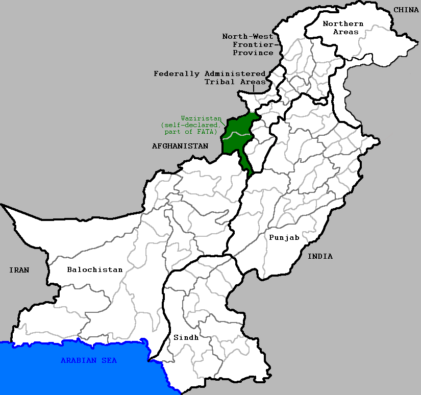

Geography and administration
The region is conventionally divided into North Waziristan and South Waziristan, each centered on a chief town—Miranshah in the north and Wana in the south. Smaller settlements such as Mir Ali and Razmak serve as administrative or market centres. Until 2018 Waziristan was governed under special frontier regulations; since then it has been integrated into Khyber Pakhtunkhwa province, a change intended to extend constitutional law, development and judicial systems into the area.
People and society
The population is overwhelmingly Pashtun and organized around tribal identities, most notably the Wazir and Mehsud confederations. Social life is governed by customary codes such as Pashtunwali and by tribal councils (jirgas) that adjudicate disputes and arrange alliances. Livelihoods traditionally combine pastoralism, small-scale agriculture, and cross‑border trade, with seasonal migration and remittances also important.
History and conflict
Waziristan has long been a frontier zone. During British colonial rule it was the focus of punitive expeditions and indirect administration. In the late 20th and early 21st centuries the area gained international attention as a base for various insurgent groups and a theatre of counterinsurgency operations. Pakistani military campaigns and international counterterrorism measures, including aerial strikes, led to periods of intense violence, displacement of civilians and later rehabilitation efforts. Major Pakistani operations in the late 2000s and mid-2010s sought to restore state control and reduce militant influence.
Economy, culture and contemporary significance
Beyond security concerns, Waziristan is culturally rich: oral poetry, traditional crafts and strong kinship networks remain central to daily life. Development challenges include limited infrastructure, disrupted education and humanitarian needs among displaced populations. The region's strategic location along the Durand Line and its tribal dynamics ensure that Waziristan continues to be important in regional politics, cross-border relations and efforts to integrate frontier districts into Pakistan's legal and economic frameworks.
Key facts
- Area: about 11,585 km2.
- Main divisions: North Waziristan and South Waziristan.
- Languages: primarily Pashto; local dialects and Urdu used in administration.
- Notable towns: Miranshah, Mir Ali, Wana.
For further context on governance and history consult regional studies and official summaries of Pakistan's frontier policy and post-2018 reforms. Major academic works and government reports provide detailed timelines and analyses of social and security developments in Waziristan.
Questions and answers
Q: What is Waziristan?
A: Waziristan is a mountainous region located in northwest Pakistan that shares a border with Afghanistan.
Q: What does the name Waziristan mean?
A: Waziristan means "land of the Wazir" in Pashto and Urdu, with the Wazir being the dominant tribe in the region.
Q: What is the size of Waziristan?
A: Waziristan covers an area of about 11,585 square kilometers or 4,473 square miles.
Q: Is Waziristan part of any of Pakistan's provinces?
A: No, Waziristan is not part of any of Pakistan's four provinces. Instead, it is part of the Federally Administered Tribal Areas.
Q: What are the Federally Administered Tribal Areas?
A: The Federally Administered Tribal Areas refer to a region in northwest Pakistan that is not part of any of the country's four provinces but rather administered by the federal government.
Q: What is the topography of Waziristan like?
A: Waziristan is a mountainous region with rugged topography that has made it challenging for the Pakistani government to establish its authority within the area.
Q: What is the significance of Waziristan's border with Afghanistan?
A: Waziristan's border with Afghanistan has made it a region of strategic importance due to cross-border movement of people and insurgency that has been fueled by the conflict in Afghanistan.
Related articles
Author
AlegsaOnline.com Waziristan: mountainous tribal region of northwest Pakistan Leandro Alegsa
URL: https://en.alegsaonline.com/art/106994
Sources
- newsday.com : "Where the Taliban still rule"
- atimes.com : "The Taliban's bloody foothold in Pakistan"
- msnbc.msn.com : "Border Backlash" · web.archive.org
- users1.wsj.com : "Musharrafistan"