
Wat's Dyke: an early medieval earthwork on the Welsh–English frontier
Wat's Dyke, a linear earthwork running near the Wales–England border, predates Offa's Dyke and served as a territorial frontier; its date and purpose remain debated after recent archaeological work.
Wat's Dyke is a continuous linear earthwork that runs along the border zone between Wales and England. Often overshadowed by the larger and better known Offa's Dyke, Wat's Dyke follows a roughly parallel course slightly to the east of Offa's work and survives now as a series of banks, ditches and disturbed ground. Although much reduced by centuries of cultivation and development, the dyke was originally a substantial artificial boundary whose visible traces continue to shape the landscape of the Welsh Marches.
Image gallery
2 Images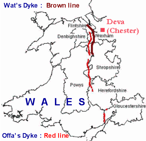
Form and location
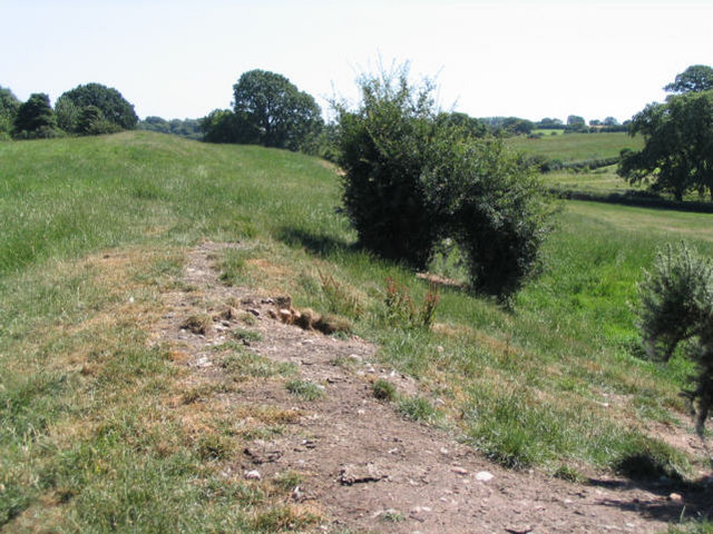
The characteristic profile of Wat's Dyke comprises a raised bank with an adjacent ditch; the ditch is positioned on the western side of the bank. Archaeologists interpret this arrangement as indicating a defensive or boundary function directed against people to the west. Surviving stretches vary considerably: some appear as a prominent embankment and hollow, others only as low traces or as cropmarks revealed by aerial photography. The earthwork runs through a mixture of upland and lowland terrain and, where intact, can be traced for several miles.
Dating and archaeological evidence
Dating Wat's Dyke has been a matter of academic debate. Traditional assessments placed its construction in the early post‑Roman period, while other researchers have argued for an 8th–9th century Mercian initiative. Excavations and radiocarbon results published in the 21st century produced dates in the range 792–852 AD, which has led some scholars to link its construction with Mercian activity during the reign of King Offa's successors. Field investigations employ stratigraphy, radiocarbon analysis and careful recording of construction techniques to refine these chronologies.
Historical context and purpose
Wat's Dyke is widely interpreted as a frontier marker. The ditch‑on‑the‑west arrangement suggests it was intended to restrict movement from the Welsh side into territories held by Anglo‑Saxons or other groups to the east. One hypothesis links its construction to Mercian responses to Welsh pressure in the early 9th century: for example, the Mercian king Coenwulf was active against Welsh polities around that period. However, the dyke might also represent an earlier boundary between local post‑Roman polities or a series of local defensive initiatives rather than a single royal project.
Relationship to Offa's Dyke and the Marches
Wat's Dyke lies inside the line of Offa's Dyke in many places and the two earthworks together helped to define the contested borderlands later known as the Welsh Marches. The presence of both dykes illustrates that the frontier here was dynamic: different actors built successive works to mark, defend or control territory. In some sections Wat's Dyke may be older than Offa's; in others it was a complementary or later modification to an already established frontier system.
Importance, conservation and public access
Today Wat's Dyke is valued for its archaeological importance and for what it reveals about early medieval territoriality. Remains are recorded and protected in varying degrees; some stretches cross public footpaths while others lie on private land. Conservation efforts and scheduled‑monument status aim to prevent further damage, and archaeological teams continue to investigate selected sites. For general readers and visitors, the dyke provides a tangible link to the networks of power, conflict and negotiation that shaped the early medieval borderlands.
- Key characteristics: bank with west side ditch, variable survival, parallel to Offa's Dyke.
- Chronology: debated; radiocarbon samples have indicated a late 8th to mid 9th century range (c.792–852 AD) while other evidence allows for earlier dates.
- Significance: a marker of territorial control in the Welsh–English borderlands and part of a larger pattern of early medieval frontier works.
For additional context on regional archaeology and boundary studies, see general resources on the border earthworks and historic Marches landscapes: ditch and earthwork research, and wider surveys of the Welsh Marches available through regional conservation bodies and academic publications (Wales) and (England).
Questions and answers
Q: What is Wat's Dyke?
A: Wat's Dyke is an ancient defensive earthwork between Wales and England.
Q: How does Wat's Dyke compare to Offa's Dyke?
A: Wat's Dyke is earlier than Offa's Dyke, but runs along similar lines, just inside the line of the later dyke.
Q: What was the purpose of Wat's Dyke?
A: The purpose of Wat's Dyke was to keep the Welsh tribes out of the areas to the east which were occupied mainly by Germanic tribes.
Q: What does Wat's Dyke consist of?
A: Wat's Dyke consists (or consisted) of a ditch and a bank. The ditch is on the west of the bank.
Q: When was Wat's Dyke built?
A: Excavations in 2006 suggested the time of building as 792-852 AD.
Q: What may have been the reason for the building of Wat's Dyke?
A: In the 820s, the Mercian king Coenwulf was fighting against a resurgent Welsh threat. That may have been the reason for the building of Wat's Dyke.
Q: What is the Welsh Marches?
A: The Welsh Marches is the area where the present boundary between Wales and England runs close to the two dykes.
Related articles
Author
AlegsaOnline.com Wat's Dyke: an early medieval earthwork on the Welsh–English frontier Leandro Alegsa
URL: https://en.alegsaonline.com/art/106885
Sources
- britarch.ac.uk : "Wat's Dyke dated: was it Coenwulf's Dyke?" British Archaeology, Nov./Dec. 2007