Vorarlberg — Austria’s westernmost state
Vorarlberg is Austria’s westernmost state, known for its Alpine landscapes, Alemannic dialect, cross‑border ties with Switzerland and Liechtenstein, and a mixed economy of tourism and light industry.
Overview
Vorarlberg is the westernmost federal state of Austria. Its administrative capital is Bregenz, while the region’s largest urban centers include Dornbirn and Feldkirch. The state is compact by area but diverse in landscape and settlement: a mix of lakeshore, valley towns and high Alpine terrain. Population figures have varied; estimates in the mid‑2010s placed the population at around 380,000 to 390,000 people.
Image gallery
10 Images


Geography and borders
Vorarlberg occupies a stretch of the Eastern Alps and shares direct land borders with neighboring countries. To the west and southwest it borders the cantons of St. Gallen and Graubünden in Switzerland, to the south it adjoins Liechtenstein, and to the north and northwest it meets Germany. The state embraces part of Lake Constance (Bodensee), whose shared waters create legal and practical links with additional Swiss and German administrative units.
Main geographic features include high peaks such as Piz Buin in the Silvretta range and important alpine and sub‑alpine valleys. Major rivers and streams drain the region into the Rhine watershed; examples are the Ill, the Bregenzer Ach and the Dornbirner Ach, which shape local agriculture, settlements and flood management.
Language and cultural identity
Vorarlberg is linguistically distinct within Austria: its traditional vernaculars are Alemannic dialects rather than the Austro‑Bavarian varieties spoken in most of the country. This linguistic affinity creates strong cultural links to neighboring Alemannic areas in Switzerland, Liechtenstein and the German region of Swabia. Local customs, folk music and building traditions reflect this cross‑border cultural zone while remaining regionally specific.
Administration, population and economy
Administratively, Vorarlberg is divided into four districts: Bregenz, Dornbirn, Feldkirch and Bludenz. The population is predominantly Roman Catholic, with a substantial minority practicing other faiths; contemporary statistics have identified Islam as the second largest religious community in the region. Precise percentages vary with census updates, but Catholicism remains the majority religion (see religions).
Economically Vorarlberg combines tourism (mountain and lake recreation), a strong tradition of craftsmanship and textiles, and modern light industry including mechanical engineering and design. Cross‑border commuting and trade with neighboring Swiss and German areas are important for employment and services.
History, tourism and notable facts
The area now called Vorarlberg has a layered history shaped by Alpine settlement, local lordships and long ties to Habsburg central Europe; over time these patterns produced the modern federal state within Austria. In recent decades the region has become notable for contemporary architecture, sustainable tourism and cultural events such as the internationally known festival in Bregenz, which uses the waters of Lake Constance as a dramatic stage.
- Distinctive dialect: Alemannic speech sets Vorarlberg apart from most other Austrian states (Austro‑Bavarian contrasts).
- Natural attractions: alpine peaks, ski areas and lakeshore recreation draw visitors year‑round.
- Cross‑border ties: close economic and cultural interaction with Switzerland, Liechtenstein and parts of Germany.
Together these features make Vorarlberg a small but distinct part of Central Europe, where alpine geography, a unique regional dialect and active cross‑border connections shape everyday life and public identity.


Geography
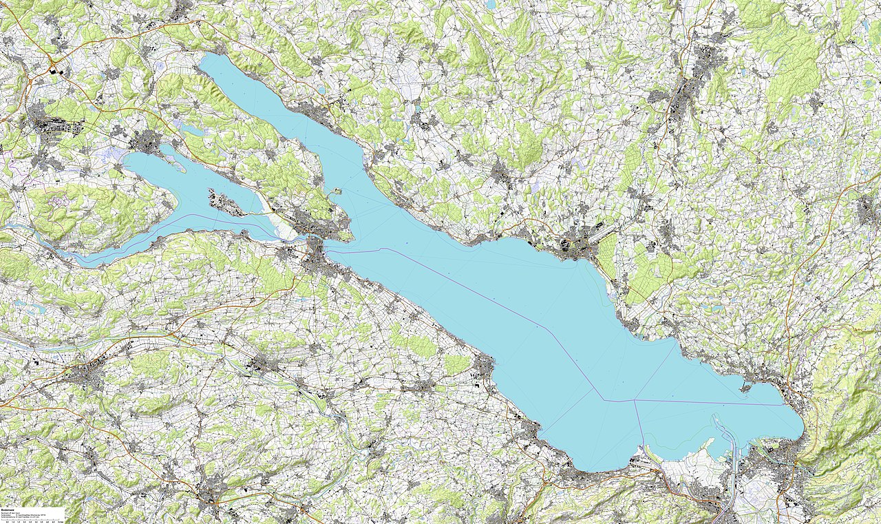
The area of Vorarlberg is generally given as 2,601.67 km². However, excluding the area of the High Lake of Lake Constance, which according to the prevailing condominium theory in Austria and Germany is jointly administered by all riparian states under international law, the state area is only 2,596 km².
The country lies between Lake Constance and the Alpine Rhine in the west, the Lechtal Alps, the Arlberg and the Verwall Group in the east, the mountain ranges of the Rätikon and the Silvretta in the south and the Allgäu in the north. The mountains north of the Klostertal and the Arlberg are counted as part of the Northern Limestone Alps.
Tectonics
The country lies in the area of influence of several fracture zones caused by the drift of the African continental plate under the Eurasian continental plate. As a result, noticeable earthquakes occur time and again, both with epicentres in Vorarlberg and radiating in from abroad, especially from Switzerland. Such zones are located under the Rhine and Klostertal valleys, in the area of the Spullersee lake, as well as just below the earth's surface near Lech, and continue eastward into Tyrol in the Inntal shear zone. On average, every 30 years or so, there is a powerful quake causing minor damage to buildings in Vorarlberg. In 1965 there was a magnitude 4 quake near Dalaas, in 1992 one with magnitude 4.3 with epicentre near Feldkirch and in 1996 two similarly strong quakes under Lech and in 2016 one with M=3.6 under Klösterle. Most recently, two quakes with magnitudes of 3.9 each, felt as far away as Innsbruck and Basel, shook Vorarlberg in early 2018, originating from the Spullersee fault. Another quake from the Spullersee fault with M = 3.1 followed in April 2018. Vorarlberg is about 2⁄3 of the earthquake hazard zone 1, the western third near the Rhine valley is zone 2 ("isolated major building damage" possible).
Valley communities
The mountainous Vorarlberg is geographically structured mainly by the valleys and their rivers:
- The Rhine Valley with the Rhine and the Walgau with the Ill are the most populated areas.
Other valleys and their rivers are:
- the Montafon (Ill)
- the Klostertal (Alfenz)
- the Great Walser Valley (Lutz)
- the Brandnertal (Alvier)
- the Laternsertal (Frutz)
- the Leiblach valley (Leiblach)
- the Bregenzerwald (Bregenzer Ach)
- the Kleinwalsertal (Breitach)
- the Lechtal (Lech) in the Arlberg region
- the silver valley (Litz)
Metropolitan areas
Vorarlberg is divided into several metropolitan areas, which are mostly connected in terms of transport or planning. The most important of these metropolitan areas is the Rhine Valley, which runs from Bregenz to Feldkirch and which, with just under 240,000 inhabitants, is Vorarlberg's largest conurbation. This means that around two thirds of Vorarlberg's population is concentrated in this area in the far west of the state.
The second largest region is Walgau with around 48,000 inhabitants. Other regions are the Bregenzerwald, the Montafon, the Lake Constance region including the Leiblachtal and the Große Walsertal. The Kleinwalsertal valley is a special geographical feature, as it cannot be reached by road from Austria and is only accessible via Bavaria. Nevertheless, it belongs to the district of Bregenz as a "functional enclave".
Part of the Vorarlberg Rhine Valley and a small part of Walgau are also included in the national green zone.
Rivers and waters
Vorarlberg's main river is the Alpenrhein, which forms the state border with Switzerland along a long stretch. The Ill is the second most important river and flows through Montafon and Walgau before joining the Rhine at Meiningen. Other important watercourses are the Bregenzer Ach and the Dornbirner Ach, as they drain large parts of the mountains of the Bregenzerwald. From the Lechquellengebirge rises the Lech, which flows in a northeasterly direction to Tyrol.
The largest lake is Lake Constance, in which Vorarlberg has a share of a good 11 % (28 km) of the shore length. Other significant lakes are the Lünersee and the Kopsspeicher, however both are reservoirs of illwerke vkw.
Passports
Vorarlberg is connected to the rest of Austria in the east by three passes that are not or only conditionally passable all year round. These are the Arlberg, the Hochtannberg (actually connecting the Bregenzerachtal with the upper Lechtal) and the Bielerhöhe in the Silvretta (between the Montafon and the Paznauntal). The Flexenpass provides the connection between the upper Lechtal, the Klostertal and the Arlberg.
A pass that is not passable all year round is the Furkajoch, which connects the Rhine Valley via the Laternsertal with the inner Bregenzerwald (Damüls). Two other important inner Vorarlberg passes are the Bödele (Losenpass 1140 m) between Dornbirn or the Rhine Valley and the Bregenzerwald and the Faschinajoch, over which a state road leads from the Bregenzerwald into the Grosswalsertal and further into the Walgau.
Important mountains and mountain ranges
The highest mountain of Vorarlberg is the Piz Buin with 3312 m height. Other well-known mountains are:
- the Zimba (Rätikon)
- the Schesaplana (highest mountain of the Rätikon)
- the Rote Wand (Lechquellen mountains)
- the Three Towers (Montafon)
- the Three Sisters (near Frastanz/Feldkirch)
- the Diedamskopf and the Kanisfluh in Bregenzerwald
- the Große Widderstein (highest mountain of the Kleines Walsertal)
- the cart in Dornbirn
- the Pfänder in Bregenz
Probably the best known mountain massif is the Silvretta in the southeast of the country. Vorarlberg's largest glaciers are also located here. Another important mountain range is the Rätikon, which is also located in the south of the country on the border with Switzerland. The mountains drop steeply towards the north. In the Bregenzerwald, the mountain heights rise gradually towards the southeast up to 2650 m (Braunarlspitze). The well-known local mountain of the state capital, the Pfänder (1064 m) in the northwest of the state, rises more than 650 m above Lake Constance, but is still one of the lowest mountains in the state.
See also: List of three-thousand-metre peaks in Vorarlberg
Nature
In Vorarlberg there are a number of protected areas with different characteristics. Such areas usually serve to preserve and safeguard the beauty, uniqueness and diversity of the natural and cultural landscape. The requirements and regulations for the establishment of protected areas are correspondingly high. For example, a region to be protected may be characterised by its unspoilt nature, be home to animal and plant species worthy of protection, or contain rare minerals or fossils. Special scenic beauty" or the recreation of the population can also be important criteria. In some protected areas, (traditional) agricultural and forestry use, such as the extensive management of litter meadows and rough pastures, is a prerequisite for an award.
The areas are decided by decree of the Vorarlberg provincial government and, depending on the purpose and content of protection, are designated as nature reserves, European nature reserves, landscape protection areas, protected landscape areas, quiet zones, nature parks or biosphere parks.
In Vorarlberg there are the following protected areas
- 39 European protected areas with a total area of 24,132 ha (approx. 9.3 % of the state area)
- 25 nature reserves with a total area of 14,256 ha (approx. 5.5 % of the state area)
- 9 protected landscape areas with a total area of 4,388 ha (approx. 1.69 % of the state area)
- 3 landscape protection areas with a total area of 584 ha (approx. 0.3 % of the state area)
- 3 plant protection areas with a total area of 4,300 ha (approx. 1.6 % of the national area)
- 1 UNESCO Biosphere Park Großes Walsertal with a total area of 19,231 ha. The biosphere park is not completely enclosed as a nature reserve, but can be explored on numerous hiking and cycling trails. With the "Biosphärenpark Haus" a visitor centre was built as an educational facility and there are guided tours by the park rangers.
- 1 Nagelfluhkette Nature Park with a total area of 15,410 ha. This park is a large protected area between Allgäu and Bregenzerwald. This park also has a strong educational background and the rangers and nature park ambassadors are available for guided tours or workshops. In the information centre "AlpSeeHaus" all aspects of the Nagelfluhkette Nature Park are centrally presented to visitors.
Natural beauty and natural spectacles in Vorarlberg
Lake Lünersee (in 2019), Lake Körbersee (in 2017) and Lake Formarin (in 2015) were chosen by the TV audience and expert jury as the "most beautiful places in Austria" in the course of the TV programme "9 places, 9 treasures" of the Austrian Broadcasting Corporation.
The Zimba is one of the most famous climbing mountains in Vorarlberg with an altitude of 2643 m a.s.l. Since the shape of the mountain reminds of a horn from all sides, it is also called the Vorarlberg Matterhorn. The approaches to the climbs are not too difficult, but the climbs themselves should not be underestimated. The highest mountain is the Piz Buin in the Silvretta with 3312 m above sea level.
The Rheindelta nature reserve is the largest wetland on Lake Constance and is one of the most important breeding and resting areas for birds.
The moor landscapes near Krumbach/Bregenzerwald belong to the protected areas due to their special biodiversity and relevance for species and flood protection. They have been made accessible for (tourist) educational purposes with a hiking trail and can also be visited with a guide. The installed information stations and moor seats explain the geology and history of the moors.
One of the most spectacular natural spectacles in the Rhine Valley is the Ebnit Valley with the Rappenloch, Alploch, Schaufelschlucht gorges, the Staufensee reservoir, the Kirchle and the Gunzenach/Kobelach. The gorges can be reached via Dornbirn and are accessible from April to October, outside this time there is a risk of falling rocks.
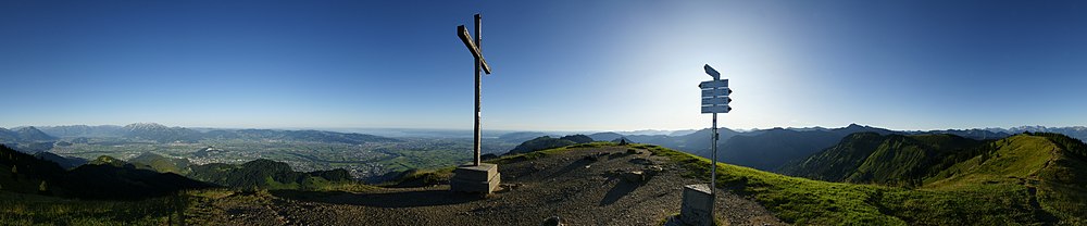
enlarge and show information about the picture
![]()
View from the Hohe Kugel in the direction of the Vorarlberg Rhine Valley and the Bregenz Forest
Political geography
See also: List of administrative districts of Vorarlberg and List of municipalities in Vorarlberg
The state is divided into four administrative districts of different sizes. These each bear the name of their capital. In decreasing order of area, these are Bludenz, Bregenz, Feldkirch and Dornbirn.
In addition to these administrative districts, there are the five judicial districts of Bezau, Bludenz, Bregenz, Dornbirn and Feldkirch. In general, the district courts located in the district capitals each cover the entire district. The district court of Bezau, which covers almost the entire Bregenzerwald as well as Kleinwalsertal, limits the area of the district court of Bregenz.
Vorarlberg is divided into 96 independent political municipalities consisting of a total of 107 cadastral municipalities. Five Vorarlberg municipalities have municipal law (Bludenz, Bregenz, Dornbirn, Feldkirch and Hohenems), a further twelve have been elevated to the status of market town.
The seat of the highest organs of the state, the Vorarlberg Parliament and the state government, is the state capital Bregenz. For the duration of extraordinary circumstances, the Governor of the Province could, according to the Provincial Constitution, order their relocation to another place in the territory of the Province.
Management structure
Political districts
| Political districts | ||||
| Automotive | District | Inhabitants | Area | Density |
| BZ | Bludenz district | 064.368 | 1.287,64 | 050 |
| B | Bregenz district | 135.310 | 0863,36 | 157 |
| DO | District Dornbirn | 090.502 | 0172,36 | 525 |
| FK | District Feldkirch | 109.057 | 0278,31 | 392 |
| V | Vorarlberg | 399.237 | 2.601,67 | 153 |
Vorarlberg is divided into four political districts. These are arranged from north to south:
Although the cities of Bregenz, Dornbirn and Feldkirch would certainly have the required size, there are no statutory cities in Vorarlberg.
Neighbouring countries
Vorarlberg has a 321 km long national border, over which it is
- to 110 km to the Federal Republic of Germany (Free State of Bavaria),
- on 107 km to the Swiss Confederation (Canton of St. Gallen and Canton of Graubünden),
- on 69 km to the Austrian federal state of Tyrol and
- borders the Principality of Liechtenstein for 35 km.
Due to the peculiarity of international law, which is unique in Europe, that there are no jointly defined state borders outside the dump off the shore, i.e. in the so-called deep area of Lake Constance, the upper lake belongs jointly to all riparian states according to the condominium theory. Switzerland, however, lays territorial claim up to the middle of the lake and no claims beyond the middle of the lake.

History
→ Main article: History of Vorarlberg
Vorarlberg had been inhabited by the Celtic tribe of the Brigantians since at least 500 BC. In 15 BC the Romans conquered the area and developed the town of Brigantium on the site of today's provincial capital Bregenz into an important military location and Lake Constance port.
Around 260 the invasions of the Alemanni began, who then settled here from about 450. With the Alemanni the area came to the Frankish Empire, in 843 to the East Frankish Empire. As heirs of the Udalrichingers, who were Carolingian counts in the Lake Constance area, among others, the Counts of Montfort gained dominion in the area of Bludenz, Bregenz and Feldkirch around 1200.
From the 14th century onwards, the individual dominions passed to the Habsburgs, who were anxious to consolidate their territories in what is now Switzerland and their Austrian possessions:
- 1363 the lordship of Neuburg am Rhein
- 1375 the county of Feldkirch
- 1394 the dominion Bludenz with the Montafon
- 1397 the lordship of Jagdberg
- 1451 half the county of Bregenz
- 1453 the courts Tannberg and Mittelberg
- 1474 the county Sonnenberg (of the Truchsesses of Waldburg)
- 1523 the second half of the county Bregenz
Numerous dominions in southwestern Germany (Freiburg im Breisgau) and present-day Switzerland (Fricktal in the later canton of Aargau) were also Habsburg possessions (Vorderösterreich). Until the 17th century, a bailiff headed the administration of the Habsburg territories in Vorarlberg.
The immigration of the Walsers from the Upper Valais (Switzerland) and Graubünden (Switzerland) also occurred in the 14th century. In the 13th century, the Alemannic population in the Upper Valais had grown so much that the space became too small for them. An expansion further west was not possible because of the strong Romanes (Duchy of Savoy), so they moved over the eastern and southern mountain passes into the neighbouring high valleys (Walser migration).
In 1765 the county of Hohenems also fell to the Habsburgs after the extinction of the count's house in the male line. With the establishment of the Tyrolean County Office of Vorarlberg in 1786, at that time for the domains of Bregenz and Hohenems, the county made its first unified appearance. In 1804 the acquisition of the dominions of Blumenegg and St. Gerold, formerly the property of the monasteries of Weingarten and Einsiedeln respectively, and finally in 1814 of the former imperial court of Lustenau rounded off the territory.
During the Napoleonic period, between 1806 and 1814, the territory of Vorarlberg belonged to Bavaria and then returned to Austria, except for the western parts of the Bregenz and Hohenegg dominions; it continued to be administered from Innsbruck.
In 1861, Vorarlberg became a crown land and, like all crown lands, received its own provincial parliament and its provincial committee as an executive body, but with regard to the administration of the state as a whole, it remained under the jurisdiction of the imperial and royal governor's office in Innsbruck. Statthalterei in Innsbruck, which represented the Emperor as sovereign and the imperial and royal government in Vienna. Government in Vienna. Remnants of this administrative unit with Tyrol still exist today, e.g. in the judicial system (Innsbruck Higher Regional Court) or in the chamber organisation (architects, notaries).
After the collapse of the Habsburg monarchy, Vorarlberg separated its administration from that of Tyrol in 1918. A referendum in 1919 advocating negotiations with Switzerland on Vorarlberg's accession to the Swiss Confederation resulted in a majority of a good 80 percent, but failed due to the hesitant policy of the (provisional) Vorarlberg provincial assembly and the Swiss Federal Council, which did not want to unbalance the carefully balanced relationship between languages and confessions in Switzerland by adding an additional canton with German-speaking Catholics, as well as the peace treaties of St. Germain and Versailles. The disparaging designation of Vorarlberg as the canton of Übrig, on the other hand, came from an opponent of the project who favored annexation to Germany. With the establishment of the Republic, Vorarlberg became an independent federal state with its own state government and a constitution that is essentially still valid today. Vorarlberg is the only Austrian federal state to call itself an independent state in its state constitution.
At the so-called Anschluss of Austria to the German Reich on March 12, 1938, Vorarlberg was de facto annexed by the German Reich along with all of Austria to the cheers of the local National Socialists. Shortly after the National Socialists seized power, Vorarlberg was forcibly united with Tyrol to form the "Gau Tirol-Vorarlberg" and dissolved as an independent territorial entity. In 1938 only very few Jews lived in Vorarlberg. The Jewish community of Hohenems, which had existed since the 17th century, was forcibly dissolved and the Jews deported to concentration and extermination camps.
Even in Vorarlberg, which was almost completely spared from acts of war, the National Socialist tyranny and the Second World War claimed human lives, including those killed for racial or political reasons and soldiers killed on the fronts. Shortly before the end of the war in the spring of 1945, the local SS shot civilians who had hung white flags from their windows "too early" when the French troops approached.
After the war, Vorarlberg belonged to the French occupation zone from 1945 to 1955, together with the province of Tyrol (except East Tyrol).
In 1964, Vorarlberg made national headlines when an angry crowd in the Lake Constance community of Fußach managed to get a ship christened "Vorarlberg" instead of "Karl Renner", the name intended by the Federal Ministry of Transport. This local protest against the central government became known as the Fußach Affair.
In 1999 and 2005, severe floods devastated parts of Vorarlberg and caused extensive damage.
Population
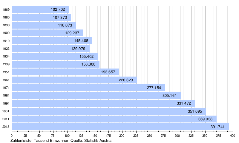
With 153 inhabitants per square kilometre, Vorarlberg is the second most densely populated province in Austria after Vienna. With the conurbation between Feldkirch and Hörbranz, it has one of the most densely populated areas in Europe. Due to the early industrialization in comparison to other Austrian states, Vorarlberg developed into a classic immigration state as early as the 19th century. Next to Vienna, the small state has the highest proportion of immigrants. In 2015, this was around 16% of the total population. The largest migrant group is made up of residents of German origin, closely followed by immigrants from Turkey. The third largest immigrant group in Vorarlberg, by far, is made up of people from countries of the former Yugoslavia.
Vorarlberg was still relatively sparsely populated until the middle of the 19th century. The regulation of the Rhine, the construction of the railway and the associated upswing in industry encouraged the settlement of Trentino people, who came to the country as workers. Numerous Italian surnames, including well-known ones such as Collini and Girardelli, are still evidence of this wave of immigration today.
The first wave of immigration, beginning in the interwar period, consisted mainly of people from eastern Austria, especially Styrians and Carinthians. During the Nazi period, a large number of South Tyrolean optants immigrated. For this purpose, the distinctive South Tyrolean settlements in the larger municipalities of the country, which are still preserved and inhabited today, were also created.
After the Second World War, several major waves of immigration reached Vorarlberg, which explains the large jump in population between 1923 and 1951 (despite the war) and between 1961 and 1971. In 1966, for example, 26.3 percent of Vorarlberg's population had been born outside the state. The first wave consisted mainly of German expellees (Sudeten Germans and Lower Styrians). The second major wave of immigration in the 1960s and early 1970s came in the form of guest workers, especially from Turkey and Yugoslavia, whose labour was needed primarily in the textile industry. This wave of migration was brought about by the relatively good economic situation in Vorarlberg and neighbouring Switzerland.
See also: Vorarlberg customs
Dialect
→ Main article: Vorarlberg
In contrast to the rest of Austria, no Bavarian dialects are spoken in Vorarlberg, but rather Alemannic dialects, which are related to the Alemannic dialects in German-speaking Switzerland, the Alemannic dialects of southern Baden and Alsace, and Swabian. The popular designation of Vorarlberg as "Ländle" refers to the Alemannic language area. The northern Vorarlberg dialect (Bregenzerwald and the provincial capital Bregenz) is most closely related to the Allgäu dialect; the dialect spoken in the Vorarlberg Rhine Valley is more closely related to the dialects of the Swiss Rhine Valley (Canton St. Gallen) and Liechtenstein. Especially in geographical terms, but also for some everyday objects, many Romansh terms have survived and spread.
Religion
In the last census conducted by Statistics Austria in 2001, about 78% of Vorarlbergers were Roman Catholic and about 2.2% Protestant. In 2015, 241,037 Vorarlbergers were still of Roman Catholic faith, which corresponded to about 64% of the population. Among the Protestant believers, the majority professed the Augsburg Confession, but there was also a small group that professed the Helvetic Confession. Muslims made up about 8.4% of the population in 2001, making Islam the second largest religious community in Vorarlberg. The number of Muslim inhabitants has increased since then and their share of the population was 11.5% in 2012. This religion mainly belongs to Turkish and Bosnian immigrants; it has an above-average presence in the district of Dornbirn, where various Muslim faith groups account for more than 10 % of the population. In the 2001 census, 20,945 persons in Vorarlberg did not belong to any religious community, which corresponded to about 6 % of the population.
Since the 2001 census, no reliable figures on the religious affiliation of the Vorarlberg population have been collected (with the exception of the Roman Catholic Church). Only the religious confession of Vorarlberg's primary school pupils is systematically recorded. These figures, in addition to the decreasing share of Catholics in the total population, indicate a strong change in the religious composition of the Vorarlberg population since 2001. Today (as of 2018), 61.3% of primary school pupils are Roman Catholic, 1.5% Protestant, 4.1% Christian Orthodox, 22.5% Muslim, 2% belong to other religious communities and 8.4% have no religious affiliation.


Related articles
Author
AlegsaOnline.com Vorarlberg — Austria’s westernmost state Leandro Alegsa
URL: https://en.alegsaonline.com/art/105922