Volga
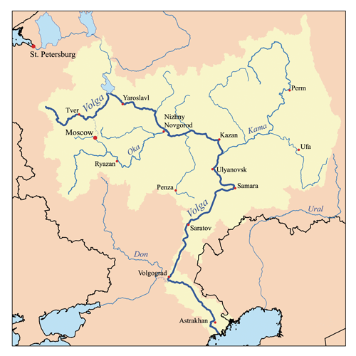
The Volga is Europe's longest river, flowing some 3,530 km across western Russia from the Valdai Hills to the Caspian Sea. It is central to Russian geography, transport, history, economy and culture.
Overview
![]()
The Volga (Russian: Волга) is the longest river in Europe, running roughly 3,530 km from its source in the Valdai Hills to its mouth in the Caspian Sea. Its basin, one of the continent's largest, drains an area of about 1.36 million km² and supports hundreds of thousands of smaller streams and tributaries. The Volga is notable not only for its length and discharge but also because it empties into an endorheic basin: the Caspian Sea, the world's largest inland body of water.
Image gallery
10 Images


Course and basin
The river begins at a modest spring and lake system in the Valdai Heights, north-west of Moscow, and flows generally eastward and then southward across the East European Plain. Along its course the Volga descends approximately 256 m in elevation before reaching the Caspian Sea, which lies about 28 m below Baltic Sea level. Major tributaries include the Oka, Kama and Sura rivers, and the river’s lower reaches expand into a broad delta before meeting the Caspian.
Navigation, canals and reservoirs
The Volga is extensively engineered for navigation and power. A series of dams and reservoirs regulate flow, generate hydroelectricity and provide inland shipping routes. It forms the backbone of a network that links the Caspian with other seas via man-made waterways: the Volga–Don Canal connects to the Don and onward to the Black Sea, while the Volga–Baltic waterway gives access to the Baltic Sea and, by extension, to northern ports.
- Navigation: large stretches are navigable year-round, with locks around major dams.
- Reservoirs: several large reservoirs alter natural flow, create lakes for shipping, and support power stations.
- Canals: engineered links provide long-distance freight and passenger routes across regions.
Economic and cultural importance
The Volga basin is a major agricultural and industrial region of Russia. Cities such as Tver, Yaroslavl, Nizhny Novgorod, Kazan, Samara, Saratov and Volgograd developed along its banks and grew as centers of manufacturing, trade and river transport. Fishing, irrigation, hydroelectricity and river shipping are longstanding economic uses. Culturally, the Volga features prominently in Russian literature, music and folklore and has shaped ethnic and demographic patterns, including historical communities such as the Volga Germans.
History and human influence
Historically the Volga served as a major trade corridor between northern, central and southern Eurasia. From medieval times it provided routes for merchants and helped link the Viking-Varangian world with the Caspian and beyond. Over centuries the river’s role evolved with the construction of modern canals, railways and roads, but it remains an arterial waterway in the region.
Environmental issues and notable facts
The Volga faces environmental pressures common to large industrialized river basins: pollution from urban and industrial sources, habitat loss from reservoir creation, overfishing and changes to hydrology. The Volga delta is ecologically significant for migratory birds and fisheries, and efforts at conservation and pollution control are ongoing. Notable facts include its status as the longest river in Europe and as one of the world’s largest rivers that terminates in an inland sea rather than the oceans.
History
Source and headwaters
The Volga River rises and runs in the western part of Russia. Its source is located in the Valday Heights near the village of Volgovskhovye (Волговерховье, 228 m).
After the water of the Volga flows down from the Waldai Heights, it reaches Rzhev and flows northeast from now on. From here small barges can navigate the river. Downstream is the city of Tver (1931-1990 Kalinin), which was founded in 1135 and lies on the trunk road from Moscow to Saint Petersburg. The Volga continues to flow through the Ivankovo Reservoir to Dubna, where it joins the Moscow Canal. The Dubna reservoir was built, among other things, to supply water to Moscow via the Moscow Canal. Via Kimry the river reaches the Uglitsch reservoir, which is dammed by a dam in Uglitsch. Further north, the Volga flows through the Rybinsk Reservoir, the oldest reservoir on the Volga. The Mologa, Suda, Sheksna and the Volga-Baltic Canal flow into this lake.
Middle course
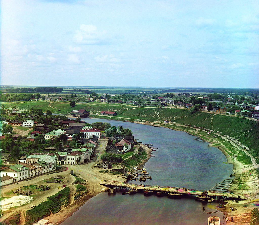
Beyond the dam is Rybinsk (1946-1957 Shcherbakov and 1984-1991 Andropov), the largest transhipment port on the upper Volga. The Volga now flows southeast and reaches Yaroslavl, one of the oldest cities in central Russia, dating from the 11th century. Today's industry here discharges most of its wastewater untreated into the river. About 70 km downstream is Kostroma, an ancient city (founded in 1152) at the mouth of the river of the same name. Behind Kineschma the Volga is dammed again, here lies the 80 km long Gorky reservoir. In Nizhny Novgorod the Oka joins the Volga from the right, which now flows eastwards. Near Novocheboksarsk in the Republic of Chuvashia, the Volga is dammed to form the Cheboksarsk Reservoir. In the 1980s, tens of thousands of upriver Mari people were resettled to make way for the lake. Cheboksary is located on the reservoir. 150 km to the east is the city of Kazan, the capital of the Republic of Tatarstan, where the Volga turns south. The city lies at the upper end of the approximately 550 km long Kuibyshev Reservoir, which at 6450 km² is the largest reservoir on the Volga and in Europe. Here the Kama flows into the Volga. On the shore lie the cities of Ulyanovsk (formerly Simbirsk) and Tolyatti (also spelled Togliatti). On the Volga bend (Russian: Samarskaya luka) lies Samara (1935-1990 Kuibyshev), a city of millions. Here the river Samara flows into the Volga from the left. At the end of the Volga loop lies Sysran.
Lower reaches and estuary
The Saratov reservoir, which begins here, was dammed at Balakovo. Below this industrial city the Great Irgis flows into the Volga. Between Balakowo and Saratow the Volga Germans used to live, before they were deported to Siberia and Kazakhstan during the Second World War. Even today, however, the towns of Engels and Marx on the left bank are reminders of the German settlement. Only on this section the Volga is still as it used to be. The characteristic form of the mountain and meadow landscape - in the form of the up to 375 m high Volga plateau in the west and the flat meadow bank in the east - is common from Kazan to Volgograd, but the reservoirs flood parts of the bank regions. Only between Balakovo and Marx the Volga is still natural.
Opposite Engels and thus west of the Volga lies Saratov, a university city with about 880,000 inhabitants. Here begins the 600 km long Volgograd Dam, on the banks of which is the city of Kamyshin. Below the dam are the cities of Volshsky and Volgograd (formerly Tsaritsyn, Stalingrad), the latter of which stretches for 80 km along the west bank of the Volga.
At Volshsky, where the Volga delta begins, the Achtuba estuary branches off from the Volga, which is by far the longest of these arms and runs parallel (northeast) to the river. The Volga reaches the so-called Volgaknie behind Volgograd, where it bends to the southeast.
The Volga-Don Canal branches off to the west in the southern part of the city of Volgograd (since 1931 a district of Krasnoarmeiski, previously an independent village of Sarepta, from 1920 Krasnoarmeisk). It was dug between 1950 and 1957, mainly by camp prisoners, and provides a connection to the Sea of Azov and the Black Sea, and thus to the Mediterranean Sea, via the Don. Below Volgograd, the Volga gradually flows into the Caspian Depression, which joins the East European Plain to the southeast.
At about the beginning of the main area of the Volga Delta lies the city of Astrakhan (formerly Itil), from where the Volga Delta branches out into numerous estuaries. Parts of the delta are protected because the area is an important stopover for migratory birds and also the habitat of numerous other animal species. The large estuaries of the Volga include Bachtemir and Tabola in the west, between which the Volga flows; a little further east, the long estuary branch Achtuba flows.
The shore of the Caspian Sea is reached by the estuary branches of the Volga about 75 to 100 km south or southeast of Astrakhan. The height of the mouth on the shore of the lake is 28 m below sea level, which gives a gradient of 256 m between the source and the mouth.


Navigability
The Volga proper is today designated as an inland waterway from Rzhev to Krasnye Barrikady (below Astrakhan) over a length of 3193 km. In addition, there are waterways of 961 km on the Volga arms below Volgograd (such as Achtuba) and in the Volga delta, as well as 1806 km of alternative routes, port accesses and the like on the reservoirs below the Rybinsk reservoir. Above Rybinsk the Volga is navigable for smaller vessels on another 250 km (up to 10 km below the source) up to the Upper Volga Lakes (Sterschsch, Wselug, Peno and Wolgo), which are additionally dammed by a weir to the Upper Volga Reservoir since 1845, but not continuously due to missing or decommissioned locks. Accordingly, this section is no longer considered an inland waterway.
See also: Steam navigation on the Volga

Related articles
Author
AlegsaOnline.com Volga Leandro Alegsa
URL: https://en.alegsaonline.com/art/105833
Sources
- cgee.hamline.edu : "The Volga River"