Vindolanda

Vindolanda was a Roman auxiliary fort, near the parish of Bardon Mill/Henshaw, hamlet of Chesterholm, county of Northumberland, England.
The Romans advanced to what is now the border area between England and Scotland in the 1st century AD. Here they concentrated most of their troops during their rule over Britain. They also began to secure the border with a dense chain of forts, such as Vindolanda, and army roads, such as the so-called Stanegate, which is still visible, in the late 1st century, after the Romans had abandoned part of their conquests in Scotland. The permanent presence of Roman soldiers from early Trajan times onwards has been proven beyond doubt on site by archaeology. The border region, which stretched across the north of England from the mouth of the Tyne to the Solway Firth, was served by a well-developed military road, known since the Middle Ages as Stanegate. It marked the first permanent boundary line in Roman Britain. The fort garrison of Vindolanda was initially responsible for security and surveillance duties on the frontier and later for controlling the hinterland of Hadrian's Wall. Due to its location at the very edge of one of Rome's most remote provinces, the inhabitants of Vindolanda were highly dependent on the use of locally available resources and their resourcefulness. Today, Chesterholm is known to contain the remains of nine successive Roman forts. Due to the practice at the time of levelling the area or covering it with a new layer of clay before starting a new build, thousands of ancient artefacts have been remarkably well preserved. The excavation site became popular nationwide mainly due to numerous fragments of ancient writing tablets recovered there. Outside the fortress was a larger civilian settlement with bathhouses, temples and an adjoining burial ground. Because of its long period of occupation, the partially still very well preserved wall substance as well as the spectacular soil finds, Vindolanda is one of the best researched archaeological monuments in the United Kingdom. Today, the extensively excavated late antique stone fort and the civilian settlement can be seen, as well as a museum with a selected collection of finds and several building reconstructions on the show grounds.
This article contains a description of the fort, civil settlement and two adjacent watchtowers in the Barcombe corridor.
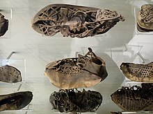
Roman leather shoes found in Vindolanda
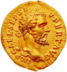
Coin portrait of Septimius Severus
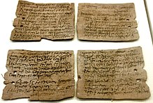
Writing tablet no. 343, request of Octavius to Candidus concerning grain supply
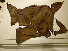
Leather remnant of a saddle
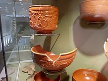
Terra Sigillata finds in the Vindolanda Museum
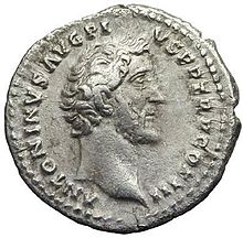
Coin portrait of Antoninus Pius
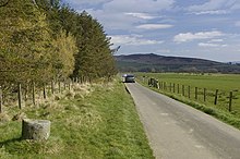
Base of a milestone on the Stanegate road at the approach to Vindolanda.
.jpg)
Replica of a milestone of the Stanegate road at the stone bridge over the Chainley Burn (2nd century).
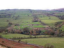
View of the fort plateau from the east
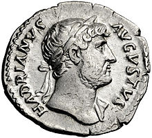
Coin portrait of Hadrian
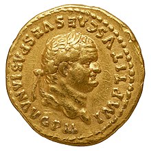
Coin portrait of Vespasian
Name
In 1914, while searching for a well 110 metres west of the fort, a worker found a sandstone altar that had been dedicated by the former inhabitants of the civilian settlement (vicani) to the ruling imperial house and the god Vulcanus. Its inscription revealed the ancient name of the settlement. The altar probably dates from the years between 223 and 225. The place name also appears in one of the Vindolanda tablets. It can be derived from Celtic. Vindo means white, but it can also be a personal or field name. The probably Latinized form Vindolanda could thus be resolved as White Fortress, White Shimmering Meadow, or House or Court of Vindo. The site is also mentioned in the two most important late antique written sources. In the Notitia dignitatum (late 4th and early 5th century) it appears as Vindolana between Borcovicio (Housesteads) and Aesica (Great Chesters). In the cosmography of the Geographer of Ravenna (7th century) it is found as Vindolanda, where it is listed between the entries for Camboglanna (Castlesteads) and Longovicium (Lanchester). In the records of antiquaries who had visited Chesterholm it is referred to as "Chesters on Caudley", "Little Chesters" and "The Bower".
Location
Vindolanda is situated in the north of England, on the border with Scotland, in the hill country of the Pennines, in that part of the island where the distance between the coasts of the North Sea and the Irish Sea is shortest. It stood about two miles south of Hadrian's Wall, on its most scenic stretch, the Whin Sill ridge, near Hexham and Haltwhistle, some 40 miles from Luguvalium (Carlisle) to the west. The Roman fort, with associated civilian settlements and burial grounds, was immediately south of the Stanegate road. The latter connected Corbridge to the east with Carlisle to the west on the Cumbrian coast. The fort stood in the trough valley of the South Tyne, on the eastern edge of a 154 × 93 metre plateau, sloping gently to the south-west and 160-165 metres high, between the watercourses of the Doe Sike to the west and the Chainley Burn to the east. From there there was a good view of the densely wooded Allen Valley and the low mountain range of the Pennines. To the east the view was somewhat restricted by Barcombe Hill and the Cod Law Ridge to the north. The latter, in particular, obscured the view of the Whin Sills range of hills. This circumstance, however, was probably of no great importance to the builders, as the fort was mainly intended to secure the Stanegate road. The terrain was otherwise flat enough and, in particular, had a sufficient water supply for a larger garrison. The Bradley and Brackies Burns first join below the plateau to form the Chainley Burn, which in turn joins the south branch of the Tyne three kilometres away as the Bardon Burn. The archaeological site is now accessible via the A69 (dual carriageway between Carlisle and Newcastle). The nearest rampart forts were Vercovicium (Housesteads) 3km to the NE and Aesica (Great Chesters c 6km to the NW). In the late 2nd century the region was part of the province of Britannia inferior, from the 4th century of Britannia secunda.
Questions and Answers
Q: Where was Vindolanda located?
A: Vindolanda was located at Chesterholm, just south of Hadrian's Wall in northern England.
Q: What did Vindolanda guard?
A: Vindolanda guarded the Stanegate, the Roman road from the River Tyne to the Solway Firth.
Q: What are the Vindolanda tablets?
A: The Vindolanda tablets are one of the most important finds of military and private correspondence written on wooden tablets found anywhere in the Roman Empire.
Q: Why are the Vindolanda tablets important?
A: The Vindolanda tablets are important for their insights into military and private life during the Roman Empire.
Q: Where were the Vindolanda tablets found?
A: The Vindolanda tablets were found at Vindolanda, a Roman fort at Chesterholm in northern England.
Q: What kind of correspondence was found on the Vindolanda tablets?
A: The Vindolanda tablets contained military and private correspondence.
Q: What did Vindolanda guard?
A: Vindolanda guarded the Stanegate, the Roman road from the River Tyne to the Solway Firth.
Search within the encyclopedia