Vienna: Capital and Cultural Heart of Austria
Vienna is Austria’s capital and largest city on the Danube, famed for imperial architecture, classical music, coffeehouse culture and a UNESCO-listed historic centre with high quality of life.
Vienna is the capital and largest city of Austria. Known in German as Wien, it sits in the eastern part of the country on the banks of the Danube (Donau). The city functions as both a municipality and a federal state (Bundesland), serving as the political, economic and cultural hub of Austria. The modern population exceeds one and a half million in the city proper, with a broader metropolitan area that is substantially larger.
Image gallery
10 Images


Urban character and landmarks
Vienna is notable for a mix of imperial monuments, ring boulevards, and green spaces. Its compact inner districts retain Baroque palaces, Gothic churches and turn-of-the-century Secessionist buildings. The historic centre, reflecting this layered development, is protected as a UNESCO World Heritage Site; visitors encounter palaces, museums and grand public buildings concentrated within a walkable core. Prominent sites include the Hofburg, Schönbrunn Palace, St. Stephen’s Cathedral and the Ringstraße ensemble.
The cityscape is divided into numbered districts that group neighborhoods with distinct characters: the central old town, the artistic quarters, residential suburbs and the Danube islands used for recreation. Public transport is extensive and integrates trams, buses and an underground rapid transit system, supporting Vienna’s reputation for accessibility and order.
History and cultural influence
Historically, Vienna grew as the seat of the Habsburg monarchy and later as capital of the Austro-Hungarian Empire until the collapse after World War I. That imperial legacy shaped its architecture, administration and international role. Equally influential has been Vienna’s contribution to music and the arts: it was home or workplace to composers such as Mozart, Beethoven and the Strauss family, and it remains a global center for classical music, opera and ballet.
Cultural life extends beyond music to a long-standing coffeehouse tradition, a rich museum scene, and festivals that draw international audiences. The city hosts major institutions and events that sustain tourism and scholarship, and its universities and research centers contribute to education and innovation.
Vienna is often cited for its high quality of life, stable public services and green urban planning. Economically it combines public administration, cultural tourism, research, and service industries. For practical visitors and residents, lists of typical attractions and activities include:
- Historic tours of palaces and the old town
- Concerts at opera houses and concert halls
- Museum visits and gallery exhibitions
- Strolls along the Danube and visits to parks and vineyards
For more detailed guides and official information see municipal resources and tourism portals that describe Vienna’s districts, services and seasonal programs; these resources often explain practical matters such as public transit, cultural schedules and visitor recommendations (city overview, heritage information). Vienna remains a city where imperial history, creative life and modern urban planning coexist.
Designation
The name of the town is pronounced [vi:n] in standard German. In the Bavarian Austrian dialect of eastern Austria, the town is called Wean [veɐ̯n]; however, this name is hardly still used to any significant extent in the Viennese dialect itself, except in special cases such as dialect cultural events.
Etymology
The name Vienna derives from the river Wien (according to the frequent naming of settlements after the tributary flowing into it). The name was first recorded in 881 in the Salzburg Annals, where a battle ad Uueniam (read: ad Weniam, "at (the) Wenia") is reported, although it is unclear whether a settlement or the river is meant. The Old High German name Wenia, from which the present one derives, derives from the Celtoroman name Vedunia ("forest stream") for the Vienna River; a Slavic intermediate form is conceivable, but not attested. The name Vindobona, on the other hand, referred to a Roman settlement within the present-day city area; it is still sometimes used for Vienna today (for example, on Latin documents), although it bears no etymological relationship to the present-day name of the city.
Name of the city in other languages
Vienna belongs to those old and internationally important cities, for which own names exist in many languages:
In English, Italian, Spanish, Romanian, Portuguese and other Romance languages, Vienna is known as Vienna or Viena, in French as Vienne, in Greek as Βιέννη (Vienni), in Dutch as Wenen, in Russian as Вена (Vena).
An independent formation is the Hungarian Bécs or Beč in Bosnian, Croatian and Serbian. The form Beç from the Ottoman official language is also derived from this (in modern Turkish it is called Viyana). The form is traced back to Hungarian rule in the 9th/10th century and is usually translated as "on the steep slope". The independent formation of the name is taken as an indication of the minor importance of Vienna in this period.
In Czech the town is called Vídeň, in Slovak Viedeň, in Polish Wiedeń and in Ukrainian Відень (Widen). These forms are etymologically unrelated to the district name Wieden.
The Slovenian name for Vienna, Dunaj, refers to the Danube (which is called Donava in modern Slovenian).
Other uses of the term
The French city of Vienne has the same name as the French name of Vienna, but its name is much older than that of Vienna. In the United States and Canada, some settlements exist that have the German or English designation of Vienne in their names. In many cases this is probably due to emigrants who named their new settlements after their place of origin.
- Vienna exists in Missouri and Wisconsin.
- Vienna is located in Alabama, Georgia, Illinois, Indiana, Louisiana, Maine, Maryland, Michigan, Missouri, New York, North Carolina, Ohio, Ontario (Canada), South Dakota, Texas, Virginia, West Virginia and Wisconsin.
- New Vienna exists in Iowa and Ohio.
- South Vienna is in Ohio.
In North America, Vienna is used as a female given name on rare occasions. A prominent example is the Californian musician Vienna Teng, who uses the given name in her stage name.
Location and landscape
Vienna lies on the eastern edge of the Alps, at the transition to the Alpine foothills in the east, which lead to the Pannonian Plain. The city centre already extends in the plain along the Danube, the western parts of the city in the Vienna Woods, the easternmost mountain group of the Northern Alps. Only a relatively small part of Vienna's urban area is built up. About half of Vienna is grassland, larger parts are also used for agriculture.
Vienna rises from 151 m above sea level in the Lobau to a height of 542 m above sea level on the Hermannskogel. In the northwest, west and southwest of Vienna, the Vienna Woods with its heights (Leopoldsberg, Kahlenberg) and forests reach into the city area. The Danube enters Vienna through the Wiener Pforte, a narrow passage between the Leopoldsberg on the right bank and the Bisamberg on the left bank. Numerous small rivers also flow into the city from the Vienna Woods, the best known of which is the Vienna River. The mountains to the west are continued to the south by glacial terraces (Wienerberg and Laaer Berg). This entire area is used for winegrowing, forming the Vienna winegrowing region.
The east of the city is characterised by the Viennese share of the flat Marchfeld, which serves agriculture but is increasingly built up. In the southeast, the Lobau is found as Vienna's share of the Donauauen National Park. In view of the predominant westerly winds (as in many European cities), the upscale residential areas tend to be located on the western edge of the city, where, among other things, the air is even cleaner, while the old industrial areas tend to be located on the southeastern edge of the city.
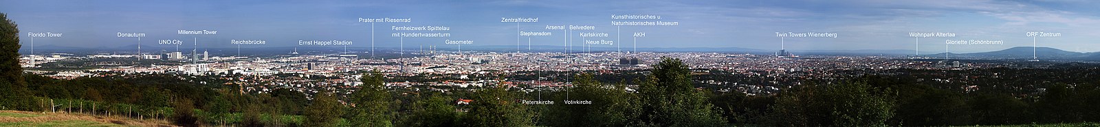
enlarge and show information about the picture
![]()
Panorama of Vienna seen from the "sky" (2005)
"Am Himmel" is located in the NW of the city, on the left you can see to NNO, on the far right to SSW
Spatial situation
Vienna owes its development into one of the most important and largest cities in Central Europe, among other things, to its favourable geographical location between the eastern edge of the Alps and the Pannonian region and the historical European axes, the south-north axis along the edge of the Alps (Amber Road) and the west-east axis along the Alpine foothills and the Danube as a waterway. Vienna developed at the intersection of these traffic routes. The historical city was formed exclusively south of the Danube: the river could be easily crossed here, as the stream in the Vienna Basin fanned out into numerous arms with islands in between. Today, the urban area stretches far on both sides of the river.
The favourable location, also in relation to the historical neighbouring countries of Moravia and the Kingdom of Hungary, and the routes towards Styria, Carniola and the Adriatic coast contributed decisively to Vienna's permanent establishment as the monarch's residence. From about 1840 onwards, this also led to the establishment of a railway network radiating out from Vienna in a star shape.
Since the fall of the Iron Curtain and the Eastern Bloc in 1989, the transport and economic relations with Austria's northern and eastern neighbours, which had been interrupted or made more difficult to use since 1945, have been growing significantly again. Vienna, for example, is only 55 km away from the Slovakian capital Bratislava (Pressburg); such proximity of two capitals is unique in Europe (apart from the special case of Vatican/Rome). The city administration has reacted to the situation by participating in the European region Centrope.
Geology
Vienna lies on the eastern foothills of the Northern Limestone Alps, which plunge here along the western edge of the Tertiary Vienna Basin and the alluvial plain of the Danube, which formed the landscape in the Vienna area from the Pleistocene to the present day. North of the city, the flysch zone overtakes the Danube and continues into the Carpathian Mountains. The subsoil of the city is formed by various geological landscapes:
- Gravels and sands of the glacial and present Danube as well as Quaternary unconsolidated sediments
- Loose rocks, especially Tertiary loose sediments of the Vienna Basin
- Solid rocks of the Flysch zone and the Limestone Alps in the western Wienerwald area
A system of north-south directed faults and fractures crosses the urban area. Powerful groundwater bodies are found in the Danube gravels.
Settlement structure
Vienna is with an area of 414.87 square kilometers the smallest province of Austria and completely surrounded by the province of Lower Austria, to which it belonged until 1920 (see Separation Act). The north-south extension is 22.8 kilometres, the west-east extension 29.4 kilometres. The highest point is the Hermannskogel (542 m above sea level) on the northwestern edge of the city, the lowest is the Lobau (151 m above sea level) on the southeastern edge of the city.
As the statutory city of Vienna has also been a province since 1920, it appears in federal state rankings: Among the provinces, Vienna has the largest share of transport and built-up areas in its total area. 11.6% of the total area is built-up land, 11.1% road traffic areas and 2.2% railway tracks. At the same time, Vienna is also the country with the largest proportion of garden land, which accounts for 28.4% or 117.76 square kilometres. Water bodies (4.5 %) account for a larger share of the total area only in Burgenland.
Vienna is one of four federal provinces in Austria that practice viticulture. 1.6 % of the area is taken up by vineyards. Forested areas cover 17.8 %, and 14.8 % of the urban and provincial area is used for agriculture.
Climate
The Viennese climate forms a transitional climate with oceanic influences from the west and continental influences from the east. This is noticeable in the yearly comparison by mostly strongly fluctuating measurement results. On the whole, Vienna usually experiences lower precipitation and longer dry periods. Winters are rather mild compared to other parts of Austria. The 30-year average air temperature in the city centre is 11.4 degrees Celsius, in the outer districts (ZAMG weather station Hohe Warte) 10.2 degrees Celsius. The average amount of precipitation is around 600 millimetres, with an average of 741.5 millimetres measured in the west of the city and only 514.5 millimetres in the east. There are 60 summer days compared to around 70 frost days. On 8 August 2013, the highest temperature ever recorded in Vienna was 39.5 degrees Celsius at the "Innere Stadt" measuring station. Vienna is home to the Central Institute for Meteorology and Geodynamics (ZAMG).
The following climate diagrams are each from different parts of the city and serve to quantify the urban climate of Vienna.
| Vienna | ||||||||||||||||||||||||||||||||||||||||||||||||
| Climate diagram | ||||||||||||||||||||||||||||||||||||||||||||||||
| ||||||||||||||||||||||||||||||||||||||||||||||||
| Climate table for Vienna Inner City (171 m)
Source: | |||||||||||||||||||||||||||||||||||||||||||||||||||||||||||||||||||||||||||||||||||||||||||||||||||||||||||||||||||||||||||||||||||||||||||||||||||||||||||||||||||||||||||||||||||||||||||||||||||||||||||||||||||||||||||||||||||||||||||||
The climate station Vienna Inner City has the warmest climate in Austria. Due to the dense development, the nightly cooling is reduced and therefore the temperature minima are markedly higher than in the surrounding area. The average wind speed is 14 km/h. Wind directions from the west, northwest and southeast dominate.
Climate table Vienna Hohe Warte
| Vienna | ||||||||||||||||||||||||||||||||||||||||||||||||
| Climate diagram | ||||||||||||||||||||||||||||||||||||||||||||||||
| ||||||||||||||||||||||||||||||||||||||||||||||||
| Climate table for Vienna Hohe Warte (202 m)
Source: | |||||||||||||||||||||||||||||||||||||||||||||||||||||||||||||||||||||||||||||||||||||||||||||||||||||||||||||||||||||||||||||||||||||||||||||||||||||||||||||||||||||||||||||||||||||||||||||||||||||||||||||||||||||||||||||||||||||||||||||
The climate station Vienna Hohe Warte is located on the premises of the Central Institute for Meteorology and Geodynamics. Due to the slope and the city effect, especially the temperature minima are moderated. The mean wind speed is 13 km/h. The prevailing wind direction is west.
Climate table Vienna Mariabrunn
| Vienna | ||||||||||||||||||||||||||||||||||||||||||||||||
| Climate diagram | ||||||||||||||||||||||||||||||||||||||||||||||||
| ||||||||||||||||||||||||||||||||||||||||||||||||
| Climate table for Vienna Mariabrunn (226 m)
Source: | |||||||||||||||||||||||||||||||||||||||||||||||||||||||||||||||||||||||||||||||||||||||||||||||||||||||||||||||||||||||||||||||||||||||||||||||||||||||||||||||||||||||||||||||||||||||||||||||||||||||||||||||
The climate station Mariabrunn is located in the relatively sparsely populated west of Vienna. Due to the formation of cold air lakes, the daily temperature minima in particular are significantly reduced compared to the inner districts of Vienna. The number of frost days is almost twice as high as in the inner city. The precipitation totals are considerably higher than in the eastern part of Vienna. The average wind speed is 9 km/h. Especially windy days occur more frequently in December and January.
Climate table Vienna Unterlaa
| Vienna | ||||||||||||||||||||||||||||||||||||||||||||||||
| Climate diagram | ||||||||||||||||||||||||||||||||||||||||||||||||
| ||||||||||||||||||||||||||||||||||||||||||||||||
| Climate table for Vienna Unterlaa (200 m)
Source: | |||||||||||||||||||||||||||||||||||||||||||||||||||||||||||||||||||||||||||||||||||||||||||||||||||||||||||||||||||||||||||||||||||||||||||||||||||||||||||||||||||||||||||||||||||||||||||||||||||||||||||||||||||||||||||||||||||||||||||||
The climate station Wien Unterlaa is located on the southeastern outskirts of Vienna. Due to the sparse development, the temperatures are lower than in the inner districts. With an average of 17 km/h the wind speed is relatively high. The main wind direction is northwest. Particularly windy days occur more frequently from December to March.
As a result of global warming, the climatic conditions in Vienna in 2050 could be similar to those found in Skopje today, while Stockholm will then have climatic conditions similar to those found in Vienna today. Model calculations also show that Vienna will be one of the European metropolises most affected by heat waves by the end of the 21st century. Accordingly, Vienna will then have a climate that is more reminiscent of today's southern Mediterranean region.
Flora
A border runs through Vienna between two floral regions, both of which belong to the Holarctic floral kingdom. Only the westernmost part of the city, belonging to the Vienna Woods, is part of the Central European Floral Region, as is almost the whole of the rest of Austria, while the rest of the city belongs to the Pannonian Floral Province, which in turn represents the westernmost part of the South Siberian-Pontic-Pannonian Floral Region. Outside of Vienna, only Burgenland and Lower Austria are part of the South Siberian-Pontic-Pannonian floral region, which stretches from South Siberia across Ukraine, Transylvania, Vojvodina and the Hungarian Plain to the eastern edge of the Alps. In addition, a sub-Mediterranean influence can be detected in Vienna. For this reason, many species grow in Vienna that are unique in Austria and worthy of protection.
In Vienna, 1490 full-status vascular plant species and 1545 elementary vascular plant taxa occur native or old naturalized. Including newcomers and non-natives, there are 2194 taxa. These are high values for a large city: by comparison, Vorarlberg, which is more than six times as large and much less densely built-up, has only 1683 full-status vascular plant species, i.e. 13 percent more.
Nature Conservation
The protection of nature in Vienna is regulated by various legal norms, such as the Vienna Nature Conservation Act, the Vienna National Parks Act and the Vienna Nature Conservation Ordinance. The following protection levels exist: European protected area (Natura 2000), national park, nature reserve, protected landscape area, protected landscape part, ecological development area, natural monument, protected biotope, biosphere park and Ramsar site.
The largest and most important protected areas are the Danube Floodplains National Park and the Vienna Woods Biosphere Reserve, which protect the east and west of the city, as well as the Bisamberg and the Alte Schanzen. In addition, there are a larger number of smaller protected areas and objects.


Questions and answers
Q: What is Vienna?
A: Vienna is the capital and largest city of Austria.
Q: Where is Vienna located?
A: Vienna is located in the east of Austria, on the river Danube.
Q: How many people live in Vienna?
A: More than 1,800,000 people live in Vienna (as of 2016).
Q: Is Vienna an administrative district of its own?
A: Yes, Vienna is an administrative district (Bundesland) of its own.
Q: What was Vienna before World War I?
A: Before World War I, Vienna was the capital of the Austro-Hungarian Empire.
Q: Is Vienna's centre a UNESCO World Heritage Site?
A: Yes, Vienna's centre is a UNESCO World Heritage Site.
Q: What are some variations in the pronunciation of Vienna?
A: Vienna is pronounced as /viˈɛnə/ in English, [viːn] in German, [veɐ̯n] in Central Austro-Bavarian, and [vɪa:n] in Viennese German and Austrian German.
Related articles
Author
AlegsaOnline.com Vienna: Capital and Cultural Heart of Austria Leandro Alegsa
URL: https://en.alegsaonline.com/art/105071
Sources
- statistik.at : "Bevölkerung zu Jahres-/Quartalsanfang"
- wien.gv.at : "Vienna in figures 2012, Vienna City Administration Municipal Department 23 Economic Affairs, Labour and Statistics Responsible for the contents: Gustav Lebhart, page 6"
- vcoe.at : "VCÖ.at: VCÖ fordert Nahverkehrsoffensive gegen Verkehrskollaps in den Städten" · web.archive.org
- ec.europa.eu : ec.europa.eu/eurostat/documents/2995521/7192292/1-26022016-AP-EN.pdf/602b34e8-abba-439e-b…
- ec.europa.eu : ec.europa.eu/eurostat/documents/2995521/7962764/1-30032017-AP-EN.pdf/4e9c09e5-c743-41a5-a…
- whc.unesco.org : "Historic Centre of Vienna inscribed on List of World Heritage in Danger"
- livius.org : "Vindobona (Vienna)"