Venice: history, geography, culture and environmental challenges
Comprehensive overview of Venice — its islands, canals, landmarks, history, transport, tourism pressures, and efforts to protect this unique lagoon city.
Venice is a city in Italy and the capital of the Veneto region (Veneto). The wider municipality, the Comune di Venezia, combines the historic islands, the lagoon and a stretch of mainland; official figures often quoted for that administrative area mention roughly 271,367 inhabitants, while the number of people living in the compact island city has declined and is commonly reported to be under 55,000. Venice is internationally renowned for its distinctive urban form, artistic heritage and fragile environment.
Image gallery
10 Images


Geography and urban form
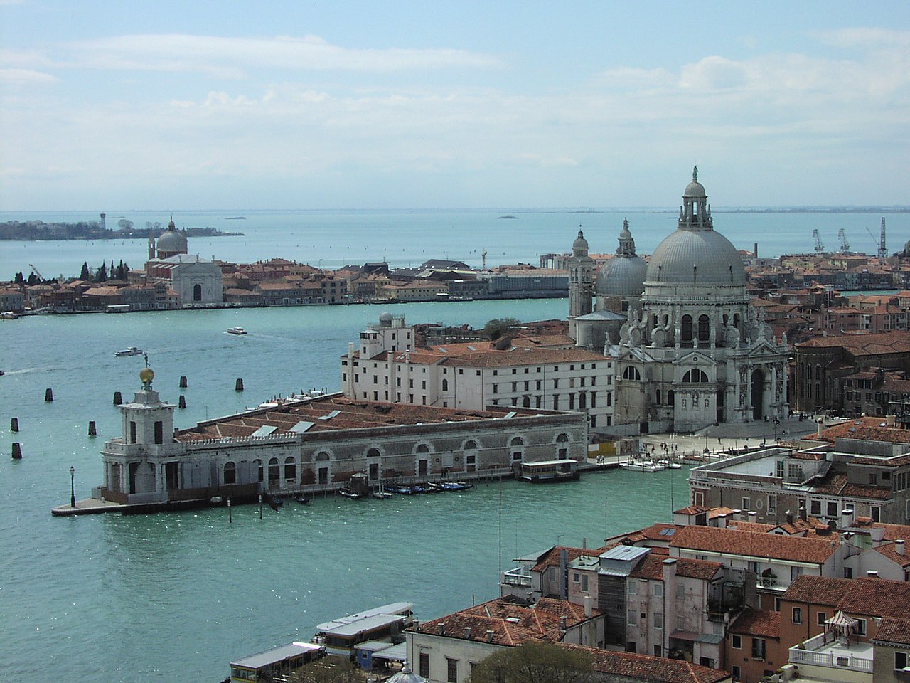
Venice stands within a shallow, brackish lagoon off the northeastern coast of Italy. The urban core is distributed across about 118 small islands linked by more than 150 canals and hundreds of footbridges. The pattern of narrow alleys, squares (campi), and waterways gives the city a compact, pedestrian-oriented character. Access and everyday transport depend on boats: traditional rowing and gondola craft coexist with motor launches and a public waterbus system, while many short crossings are served by small footbridges and causeways.
History and cultural legacy
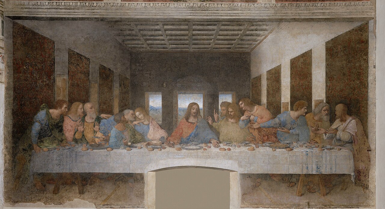
Founded in the early Middle Ages by people seeking refuge from mainland invasions, Venice grew from a lagoon settlement into a major maritime republic and trading power between East and West. Its prosperity during the late medieval and Renaissance periods financed major artistic and architectural achievements. Visitors most often seek monuments such as St. Mark’s Basilica and the Doge’s Palace, but the city’s influence extends to painting, music, architecture and law. Historic crafts — notably glassmaking on nearby Murano and lace from Burano — remain important cultural markers.
Architecture, landmarks and daily life
Venice’s architecture blends Byzantine, Gothic and Renaissance styles adapted to lagoon conditions: palazzi with water entrances, ornate facades and raised pavements. Famous sites include the Rialto area and Bridge, St. Mark’s Square and Basilica, and the Doge’s Palace; lesser-known quarters preserve neighborhood shops, artisan workshops and markets that shape daily life. Gondolas — the iconic narrow boats often associated with romance and tourism — coexist with more mundane transport: vaporetti (public waterbuses), taxis and cargo launches.
Tourism, economy and social change
Tourism is a major economic driver: millions of day-trippers and overnight visitors arrive each year to see the canals and monuments. This flow has boosted local services but also created pressures — crowding, rising housing costs, and the erosion of resident communities. Many observers note a steady exodus of long-term inhabitants in the historic center as tourism and second-home ownership reshape neighborhoods. The city remains a leading international destination and a focal point for cultural events.
Environmental challenges and protection efforts
Venice faces a combination of natural and human-made risks. The city experiences periodic high tides (acqua alta), gradual ground subsidence and the impacts of sea-level rise — phenomena that together increase flood frequency and threaten buildings and infrastructure. The MOSE project, a system of movable barriers at lagoon inlets, was designed to reduce flooding from high tides; its construction and effectiveness have been the subject of technical, financial and political debate. Scientists and conservators emphasize that long-term resilience will require an integrated approach to water management, building maintenance and sustainable tourism, rather than a single technological fix.
Preservation, festivals and distinctiveness
Venice is recognized as a UNESCO World Heritage site in part because of its unique relationship between built environment and lagoon. Ongoing conservation addresses salt damage, erosion of foundations and the upkeep of mosaics and frescoes. Cultural traditions — including the annual Carnival with its masks and costumes — and neighborhood festivals help sustain local identity. Visitors are encouraged to look beyond headline landmarks and engage with Venice’s neighborhoods, crafts and quieter canals to appreciate the city’s full complexity.
- Key transport: gondola, public waterbus, taxis and walking.
- Notable crafts and islands: Murano glass, Burano lace and artisan workshops.
- Major concerns: flooding, subsidence, overtourism and conservation costs — see also tourism impact.
- Future outlook: protective measures and community efforts aim to slow deterioration and preserve living culture; long-term scenarios remain uncertain about sea-level rise.
For further reading and official information consult municipal sources, heritage organizations and scientific studies that address Venice’s hydrology, urban conservation and cultural management. Additional contextual resources can be found through regional portals and cultural institutions linked above.

Geography
Geology
→ Main article: Venice Lagoon
The settlements that gave rise to Venice lie on alluvial land created by post-glacial rivers. The lagoon formed in their estuaries covers an area of about 550 km² and is separated from the Adriatic by sandbanks about 60 km long. Only about three percent of this area is covered by islands, the rest consists of mudflats and marshes, the Barene, which cover over 90 km², then about 92 km² of fishing grounds, the Valli da pesca. The Barene are crossed by natural channels called ghebi. Around 1900, the Barene covered more than 250 km². In contrast to the frequently flooded Barene, the Velme, shoals, bear little vegetation because they only surface at very low water levels.
The lagoon was formed from about 4000 BC by sediments from the Brenta and other rivers and streams of northern Italy. These river sediments cover a Late Pleistocene basal layer of clay and sand that is between 5 and 20 m thick. During the last cold period, sea level was about 120 m below 2012 levels, but rose by 110 m by about 5000 BC. Since then, the water level has continued to rise slowly with strong fluctuations.
Venice was still about 1.9 m below sea level in 1897 around 400 A.D. From the High Middle Ages onwards, the lagoon was subject to profound changes, such as the diversion of tributaries to regulate water levels and prevent siltation. Since the early 20th century, numerous channels have been deepened and widened, bringing considerably more salt water into the lagoon and increasing the flow velocities.
Climate
The city is located in the temperate climate zone. The average annual temperature is 13.5 °C. The warmest months are July and August with an average of 23.1 and 22.6 °C respectively, the coldest month is January with 3.0 °C. The average daily maximum temperature is 27 °C in July and August. The lagoon of Venice is characterized by the maritime climate of the northern Adriatic. This explains the precipitation peaks during the onset of late summer, as at this time the continental climate from the Eastern European mainland, in particular the Carpathians (Bora winds), and consequently the reversal of weather conditions from the southern side of the Central European Alps, have an impact. The average annual precipitation is 770 mm. The most precipitation falls in November with an average of 86, the least in January with an average of 53 mm.
| Venice | ||||||||||||||||||||||||||||||||||||||||||||||||
| Climate diagram | ||||||||||||||||||||||||||||||||||||||||||||||||
| ||||||||||||||||||||||||||||||||||||||||||||||||
| Monthly average temperatures and precipitation for Venice
Source: wetterkontor.de | ||||||||||||||||||||||||||||||||||||||||||||||||||||||||||||||||||||||||||||||||||||||||||||||||||||||||||||||||||||||||||||||||||||||||||||||||||||||||||||||||||||||||||||||||||||||||||||||||||||||||||||||||||||||||||||||||||||||||||||||||||||||||||||||||||||||||||||||||||||||||||
flora and fauna
The northern part of the 550 km² lagoon contains mainly fresh water and is hardly touched by the tidal change, which reaches about 418 km². It is therefore called Laguna morta (dead lagoon). The saltwater lagoon, on the other hand, whose water level sinks and rises with the tide and which is more strongly flushed by seawater, is called laguna viva (living lagoon). The barene provide a favourable habitat for a variety of species, but they have been greatly reduced in size. While they covered 20 percent of the lagoon's area around 1900, by 1930 they covered only 13 percent, and now they cover only 47.5 square kilometers. When another industrial area was to be developed in the 1960s, the Casse di colmata, as they were called, were withdrawn from any economic use in order to develop them into an industrial area. Large quantities of mud and concrete were placed there, creating new islands that rose an average of 2 metres above the water. But the project came under criticism after the disastrous flood of 4 November 1966, was halted in 1969 and finally ended in 1973. These areas have since become of paramount importance for migratory birds, with a core of 11.54 sq km. The World Wide Fund For Nature declared the area one of the most important protected areas for migratory birds in Europe, which includes the fishing grounds.
The flora and fauna of Venetian waters are characterized by great species richness. That is why eel, mullet, sea bass, sea bream and many other fish species are offered on the market here. They come from the fishing grounds of the lagoon, where birds, mammals and reptiles also live.
Over 60 bird species breed in the lagoon alone. Among the permanent birds you can find mallard, marsh harrier, pond rail, coot, Kentish plover, common tern, pied tit, but also purple heron, night heron, redshank and great crested grebe. In addition, great crested grebes and black-necked grebes, great egrets and various duck birds winter here. More than half of the Dunlins that winter in Italy do so in the lagoon.
Mammals include the dwarf mouse, water shrew, polecat, beech marten, large vole, weasel, but also brown-breasted hedgehog. The yellow-green wrath snake, the grass snake and the dice snake also live here. In addition, there are numerous insect and spider species.
In terms of plants, there are numerous species from the genus Queller, beach lilac and salt marsh. The vegetation below the water level is formed by two communities of seed plants that are of great importance for the ducklings, namely the dwarf seagrass, belonging to the seagrasses, and the marine salde, belonging to the saldes, which is found mainly in areas of lower salt concentration on stable substratum. In addition, reeds, bulrushes, especially the species broad-leaved bulrush are found. Most of these species live in the fishing grounds, not in the open lagoon, because the marshes (paludi) have been largely destroyed. For some years now, the partial opening of the Valli has been discussed in order to allow the species present there to spread again outside the fishing grounds.
Of the original woods, only the park of Villa Matter in Mestre and the 230 hectares of the Carpenedo forest remain. There you can find mainly hornbeam and English oak. In the meantime Mestre is surrounded by forests, among them the Bosco dell'Osellino, the Bosco di Campalto and the Boschi Ottolenghi. In 1984, the population had opposed the construction of a hospital directly opposite the Carpenedo forest and had successively enforced the extension of the woods. In addition, the huge garbage dump between Mestre and the lagoon, which covers an area of 7 km², is being transformed into a park, the Parco San Giuliano. In addition, there is the Parco Albanese between Mestre and Carpenedo, which covers 33 ha.
Extent, location and administrative structure
Venice is the capital of the Metropolitan City of Venice, which was created from the Province of Venice on 1 January 2015. The city of Venice includes the historic center with an area of about 7 km² as well as most of the Venice Lagoon with its more than 60 islands (1). It also includes the long islands of Lido and Pellestrina (2), which separate the lagoon from the Adriatic Sea, and the mainland districts of Favaro Veneto (3), Mestre (4), Chirignago and Zelarino (5), and Marghera (6).
The city has been divided into six districts or Municipalità since 2005. The Municipalità Venezia-Murano-Burano (1) comprises the historic centre, i.e. what is often called the old town in German. This is in turn subdivided into six sestieri, three of which lie to the left and right of the Grand Canal, which flows through the old town in the form of a broad question mark from west to east. To the right, approximately west and south of the Grand Canal, are the three sestieri of San Polo, Dorsoduro, which includes the islands of Giudecca on the southern edge of the old town, and Santa Croce. On the left, generally east and north side of the Grand Canal are the sestieri of San Marco, which includes the island of San Giorgio Maggiore, Cannaregio and Castello. Traditionally, the sestieri to the left and right of the canal were designated from the perspective of the Doge's Palace, that is, the sestieri located on this side of the canal from this perspective were designated citra (this side), while those on the other side of this main waterway were designated ultra. In addition to the six sestieri of the old town, the district includes the central and northern parts of the lagoon with numerous islands, the most important of which include the glassblowing island of Murano, the northeastern trio of islands of Burano, Mazzorbo and Torcello, and the vegetable islands of Sant'Erasmo and Vignole.
The Municipalità Lido-Pellestrina, on the other hand, occupies the eastern part of the lagoon with the spit stretching from Chioggia to Jesolo, which closes the lagoon to the Adriatic Sea. The two narrow, long sandbanks extend for more than 20 km southwards from Venice. The more northerly Lido di Venezia developed in the 19th century into a fashionable seaside resort with luxurious hotels and a casino; Pellestrina, on the other hand, lives mainly from fishing and shellfishing. Chioggia, situated on the southern edge of the lagoon, is not part of Venice.
In addition to these two insular Municipalità, there are four others on the mainland. The Mestre-Carpenedo district was incorporated into Venice in 1926 and is home to more than half the city's population. Attempts to reincorporate Mestre from the municipality of Venice failed in five referendums. After 2003 (48% in favour of partition), a new referendum failed on 1 December 2019, with an exceptionally low turnout of 21%, initiated by the Lega and Five Star Movement. The industrial district of Marghera is also on the mainland and is characterized by the petrochemical industry. The district of Favaro Veneto is northeast of Mestre and includes Marco Polo Airport. The Municipalità Chirignago-Zelarino includes the mainland districts of Chirignago, Cipressina, Zelarino, Trivignano and Gazzera, the western suburbs, and is the only Venetian municipalità without access to the lagoon.


Structure of the old town
The old town of Venice is made up of 118 islands, with canals of varying widths running between them. Many of these islands include a square as a centre of communication, traffic and commerce, where a parish church stands. However, changes from the early 19th century onwards have overlaid this structure, such as the construction of the wide Strada Nova or Via Eugenia (now Via Garibaldi).

enlarge and show information about the picture
![]()
Panoramic view of Venice 1870
Function assignments
In addition to this basic structure, some districts have very different structures due to various historical functions, such as around St. Mark's Square the former centre of power and representation of the city. The largest square in the city, measuring 175 m in length and up to 82 m in width, is dominated by the adjacent state buildings, in particular the Doge's Palace and the Procuraties. In addition, there are libraries and museums, St. Mark's Church and the Campanile, but also four large cafés. On the other side of the Grand Canal, Campo San Polo is the largest square.
To the east, the Arsenal covers more area than St. Mark's Square. It was home to the shipbuilding industry, which was important for Venice, and is a restricted military area. Its surroundings have the typical characteristics of an industrial district; at times over 10,000 workers were employed in this district. Ship production there is "reminiscent of industrial assembly line production in its principles of standardization and systematization." Around the arsenal lived the workers in this largest factory of the Middle Ages, the "arsenalotti".
Since the mid-19th century, the western part of the city has been the most marked by the link with the mainland. The large bridge to the mainland, the Ponte della Libertà, which was built in 1931 as a road bridge next to the railway bridge completed between 1841 and 1846, opens out there. At its head the railway station extends, and at the end of the Ponte della Libertà there is a multi-storey car park and a bus stop at Piazzale Roma. Further southeast, a track ends at Stazione Marittima, from which rail freight traffic connects to the small port. In addition, with Tronchetto, an artificial park island of over 18 hectares was filled in.
On the south side of the city, the Zattere stretch from the aforementioned Stazione Marittima in the west to the Grand Canal, then further east the Riva degli Schiavoni from the Doge's Palace to the grounds of the Biennale. This south side is used as a promenade. Similarly, the opposite north side of the Giudecca is almost the only one that still has industrial structures, such as the Stucky Mill. This structure was built in 1895 according to the plans of the architect Ernst Wullekopf from Hanover.
In many neighbourhoods the more mixed social structure is preserved, but some of them have become poor neighbourhoods, such as Sacca Fisola. The area around the Arsenale up to Via Garibaldi can rather be considered as a typical working class neighbourhood. Although the Serenissima often settled members of different nationalities in their own streets, as can often be seen from the names of the alleys (Calle dei Greci, etc.), there is little evidence of this division any more. Only the ghetto, the quarter in which the city's Jews lived from 1516 to the early 19th century, has its own structure and construction of houses. All Venetian Jews were forced to live there, divided by "nations." In addition to them, the municipality exerted an influence on local conditions through the responsible office-holders, the cattaveri, but also the Christian owners of the houses and wells with whom the Jews lived for rent - as the decree of March 29, 1516 explicitly states, the previous tenants were to leave their houses and the new tenants were to pay a rent increased by one third. Thus houses with up to eight storeys and often very low ceilings were soon built. In addition, the living conditions were very cramped - in 1552 900 inhabitants lived on an area of about three hectares, in 1611 there were 5500 - and soon the ghetto had to be expanded. From 1633 onwards, the Ghetto novissimo (i.e. the new, old and newest ghetto) was created alongside the Ghetto novo and the Ghetto vecchio.
Streets with the same functions were already established here and there in the late Middle Ages, such as in the area of the Rialto Market and around the Carampane, the former quarter of prostitutes, around the Arsenal and the Doge's Palace, but this was difficult to reconcile with the insular structure. The dominance of water traffic is evident along the Grand Canal, which is only accessible in parts by pedestrians. This is especially possible around the Rialto Bridge, the former commercial centre of the city. Instead, since the late Middle Ages, the representative palace buildings of the city nobility, the palazzi or case (houses) (hence names such as Ca' Foscari), have clustered along the canal. These cases were owned by many-headed families of the same name, such as the Contarini, who, however, broke up into several dozen branches that had little to do with each other. For this reason their palaces are referred to not only as Ca' Contarini, but in more detail by the name of the parish to which they belonged, sometimes also the name of later owners or conspicuous peculiarities. This is how names come about such as Palazzo Barbarigo della Terrazza (it features a large terrace) or Palazzo Grimani di San Luca, which was built in the 16th century in the parish of St. Luke.
Around this core area of the city there are numerous islands, which were already assigned different tasks in the Middle Ages: a cemetery island (San Michele), one for the glassblowers (Murano) or one for vegetable production (Sant'Erasmo), others served for the military protection of the lagoon.
House building
The sites of the lagoon were built on millions of wooden piles that were driven into the subsoil. It was discovered early on that underneath the mud there was solid clay, the caranto (late Latin caris, rock), and that buildings could be erected on piles driven into this layer. On this first level rested the so-called zattaron, a kind of pontoon made of two layers of larch planks fixed with bricks. The foundation walls and finally the above-ground masonry were supported on the zattaron. The buildings themselves, in order to save weight, were built of light, hollow clay bricks, the mattoni.
Many buildings are in poor condition despite recognizable efforts. The reasons for this are, on the one hand, the rise in the water level, which makes the lowest floor of most buildings uninhabitable. Secondly, since the end of the Republic of Venice, the maintenance of buildings and canals has been neglected. The currents in the lagoon caused by the ebb and flow of the Adriatic Sea have been further exacerbated by the dredging of deep channels for the overseas ships heading for the port of Marghera, so that foundations have been washed out. Finally, apartments in the old town are considerably more expensive than on the mainland and are therefore often uninhabited.
Streets, alleys and squares
The Venetians distinguish the footpaths and squares very carefully. The main streets Rughe (from the French Rue) and the Salizade, the first alleys covered with pavement from the second half of the 13th century, are limited in number. Calle are called the narrower streets and fondamenta are the streets along the canals, which also serve as foundations for the buildings. Lista is the stretch of road near the important palaces and the embassies, which enjoyed a special immunity. Mercerie are the streets with the shops (merce = goods), the rive (banks) run along the side canals. A rio terà is a filled-in canal, a ramo (branch) a short street that branches off from a calle or campiello, a small square. A campo is a square where a church stands, a larger open space that used to be a vegetable garden or pasture for horses. Campiello is a square surrounded by houses, onto which the calli flow, corti are the courtyards of the houses. Paludo recalls that this area used to be marshy, instead of the pissine there were ponds where you could bathe and fish. The Sotoportego goes under the houses (Portego is called the hall on the first floor, so the path goes under this hall) and connects Calli, Campielli and Corti.
The squares (campi) and piazzas (campielli) are distinguished from the piazza, by which is meant Piazza di San Marco, St Mark's Square, even if there was a Piazza di Rialto. Just as Piazza means St. Mark's Square, Piazzetta means the square in front of the Doge's Palace that connects St. Mark's Square with the Molo, the landing shore on the lagoon. The Piazzetta dei Leoncini is the part of St. Mark's Square north of St. Mark's Basilica, named after the two lion statues placed there. The square with the bus station, on the other hand, is called Piazzale Roma. There is only one Strada, the Strada Nova, in addition to three Vie (Via 25 Aprile, Via Vittorio Emanuele and Via Garibaldi).
Canals and bridges
→ Main article: Waterways in Venice
Venice has about 175 canals with a total length of about 38 km. The main artery is the Grand Canal, plus many waterways outside the historic centre. The tidal difference used to be 60 cm. A system of water regulation ensured a constant circulation that purified the city and the water. The canals were originally designed to be about 1.85 m deep. However, from the late 18th century they were not cleaned until the 1990s. In addition, since the 18th century, numerous canals have been filled in or abandoned, as can be seen in many cases from the name "rio terà". For example, the wide Via Garibaldi was created by filling in a canal, and in 1776 the Rio de le carampane was filled in. There is a small square there.
There are 398 bridges in the city. Until about 1480 they were mostly made of wood, later they were replaced by stone bridges. Nowadays only two of them are without railings, one of them is the Devil's Bridge (Ponte del Diavolo) on the island of Torcello, the other one opens up a private house in Cannaregio (3750). Many of them were built very flat to make them passable for horses and carts. The Rialto Bridge was the only bridge over the Grand Canal until the middle of the 19th century. In the meantime, three more have been added, namely the Ponte degli Scalzi near the railway station, which replaced an iron predecessor bridge from 1856 in 1932, and the Ponte dell'Accademia near the eponymous cultural institute, which was built from 1854 and replaced in 1933. A fourth bridge, the Ponte della Costituzione was inaugurated in 2008. This bridge connects Piazzale Roma with the waterfront (Fondamenta S. Lucia) east of Santa Lucia station.
One of the most famous bridges, the Bridge of Sighs (Ponte dei Sospiri), connects the former state prisons on the ground floor, the so-called Pozzi, with the Doge's Palace. The Straw Bridge (Ponte della Paglia), which spans the Rio di Palazzo at the Doge's Palace, is so named because boats loaded with straw used to dock there. Other bridges are named after the Rio they span, a nearby palace or church, often after a saint. The name Ponte storto, which occurs probably ten times in Venice, refers to a bridge that crosses a Rio at an angle.
The bridge over the Grand Canal, which connects the churches of Santa Maria del Giglio and Santa Maria della Salute, is a special event that takes place every year on 21 November. A procession takes place on it in thanksgiving for the deliverance from the plague of 1630/1631. A similar event takes place on the Saturday before the third Sunday of July with the bridge crossing the Canale della Giudecca to the church of Il Redentore. With this Festa del Redentore people express their gratitude for the salvation from the plague of 1575/1576.
By far the longest pair of bridges forms the only dry connections from the mainland to the island world of the Centro Storico: from 1841 to 1846 the railway bridge (Ponte Vecchio, Old Bridge, Ponte della Ferrovia) was built, connecting Mestre railway station with Santa Lucia railway station (in the Cannaregio district) in the Centro Storico. It is 3605 m long. It is electrified and has an island with trees about in the middle on its northeast side. The road bridge, which was built between 1931 and 1933, was renamed after the Second World War to Liberty Bridge (Ponte della libertà), in commemoration of the liberation from fascism. It is 3623 metres long, connecting Mestre with Cannaregio and Santa Croce, and rests on 222 stone arches. (The total length of 3850 m according to Structurae includes the right turn to Santa Croce).


Questions and answers
Q: What is the population of Venice?
A: The population of the 'Comune di Venezia', which is Venice, its lagoon and its mainland is 271,367. However, the population of Venice itself keeps on shrinking at an alarming rate and is now under 55000 locals.
Q: How many islands are there in Venice?
A: There are 118 small islands that are separated by 150 canals in Venice.
Q: What type of boats do people use to navigate across the city?
A: People can navigate across the city on boats, both rowing boats and motor boats. The most famous Venetian type of boat called a gondolas.
Q: What are some popular tourist attractions in Venice?
A: Some popular tourist attractions in Venice include the Rialto Bridge, St Mark's Basilica and the Doge's Palace.
Q: What makes Venice unique from other cities?
A: Its lifestyle and culture are unique in the world and it can get confusing at first. Additionally, there are several problems in Venice but it still remains one of the most popular tourist attractions in northeast Italy.
Q: Is there any danger that could eventually lead to all of Venice being underwater?
A: Eventually, the city might be completely underwater but that would take decades due to ground made from mud sinking a few millimeters every year. To prevent this from happening, Italian government has built MOSE Project which is a state-of-the-art defense against sea-water flooding that will safely protect Venice indefinitely.
Related articles
Author
AlegsaOnline.com Venice: history, geography, culture and environmental challenges Leandro Alegsa
URL: https://en.alegsaonline.com/art/104565
Sources
- veneziaautentica.com : "7 things you couldn't live without and never knew you owed Venice, Italy"
- veneziaautentica.com : "You asked, we answered: 19 things you might not know about Venice, Italy"
- veneziaautentica.com : "People say many things about the phenomenon of acqua alta in Venice. Here is the truth"
- veneziaautentica.com : "Become a Friend of Venezia Autentica and Enjoy your Special Treatment in Venice"
- cntraveler.com : "How Venice's Artisans Are Working to Save the City"