Vancouver, British Columbia
Vancouver is a major coastal city and seaport in southwestern British Columbia, Canada, known for its natural setting, cultural diversity, film industry and role as a regional economic and transportation hub.
Overview
Vancouver is a coastal city and major seaport on the mainland of southwestern British Columbia in Canada. The city itself has a population of over 630,000, while the broader metropolitan area—commonly called Metro Vancouver—contains more than two million residents. Vancouver's downtown core is compact and walkable, with high-density neighbourhoods situated beside extensive waterfronts, parks and a working harbour. The city functions as a regional centre for commerce, education, culture and transportation.
Image gallery
10 Images


Geography and climate
Vancouver occupies a narrow coastal plain bounded by the Strait of Georgia, Burrard Inlet and the Coast Mountains. Its temperate coastal climate produces mild, wet winters and warm summers relative to much of Canada, encouraging outdoor recreation year-round. The shoreline supports port facilities, marinas and a continuous network of waterfront trails that link neighbourhoods and green spaces.
History and Indigenous peoples
The area is on the traditional territories of Indigenous nations, including the Musqueam, Squamish and Tsleil-Waututh peoples. European settlement and industrial development accelerated in the 19th century, tied to rail connections, forestry and shipping. Successive waves of immigration have shaped the city’s neighbourhoods, languages and institutions.
Economy, culture and film
Vancouver’s economy blends port activities and international trade with sectors such as technology, tourism, higher education and creative industries. The city is a major centre for film and television production—often called "Hollywood North"—and hosts museums, galleries, festivals and performing arts venues that reflect its multicultural population.
Population and diversity
Vancouver is notable for its diverse population. A majority of residents are immigrants or children of immigrants, and more than half of city residents report a first language other than English. Many communities maintain languages and cultural traditions from Asia, Europe and other regions, contributing to a wide range of restaurants, places of worship and cultural organizations. For summaries of language use and demographics consult local language profiles here.
Transport, parks and education
The region is served by an international airport, a busy marine port and an integrated transit network linking suburbs to the city centre. Vancouver is also known for large urban parks, most notably Stanley Park, and numerous smaller neighbourhood parks, trails and waterfront promenades. The city hosts major universities and colleges that contribute to research, arts and professional services.
Planning and challenges
Vancouver is frequently discussed in debates about housing affordability, urban planning and sustainability. Municipal and regional governments focus on issues such as transit-oriented growth, green building, protection of natural areas and reconciliation with Indigenous peoples.
Quick facts
- Coastal location: a major Pacific seaport and gateway for Asia-Pacific trade.
- Natural setting: close to mountains, islands and extensive urban parks for year-round recreation.
- Multilingual city: many residents report a first language other than English; see demographic and language resources here.
- Regional role: part of Metro Vancouver, linked by transit, industry and shared services.
- National context: one of Canada’s largest metropolitan areas and a prominent cultural and economic centre in Canada.
For travel planning, municipal services and more detailed demographic or economic data, consult official city and regional resources as well as cultural and tourism guides.
Geography
Location and neighbouring towns
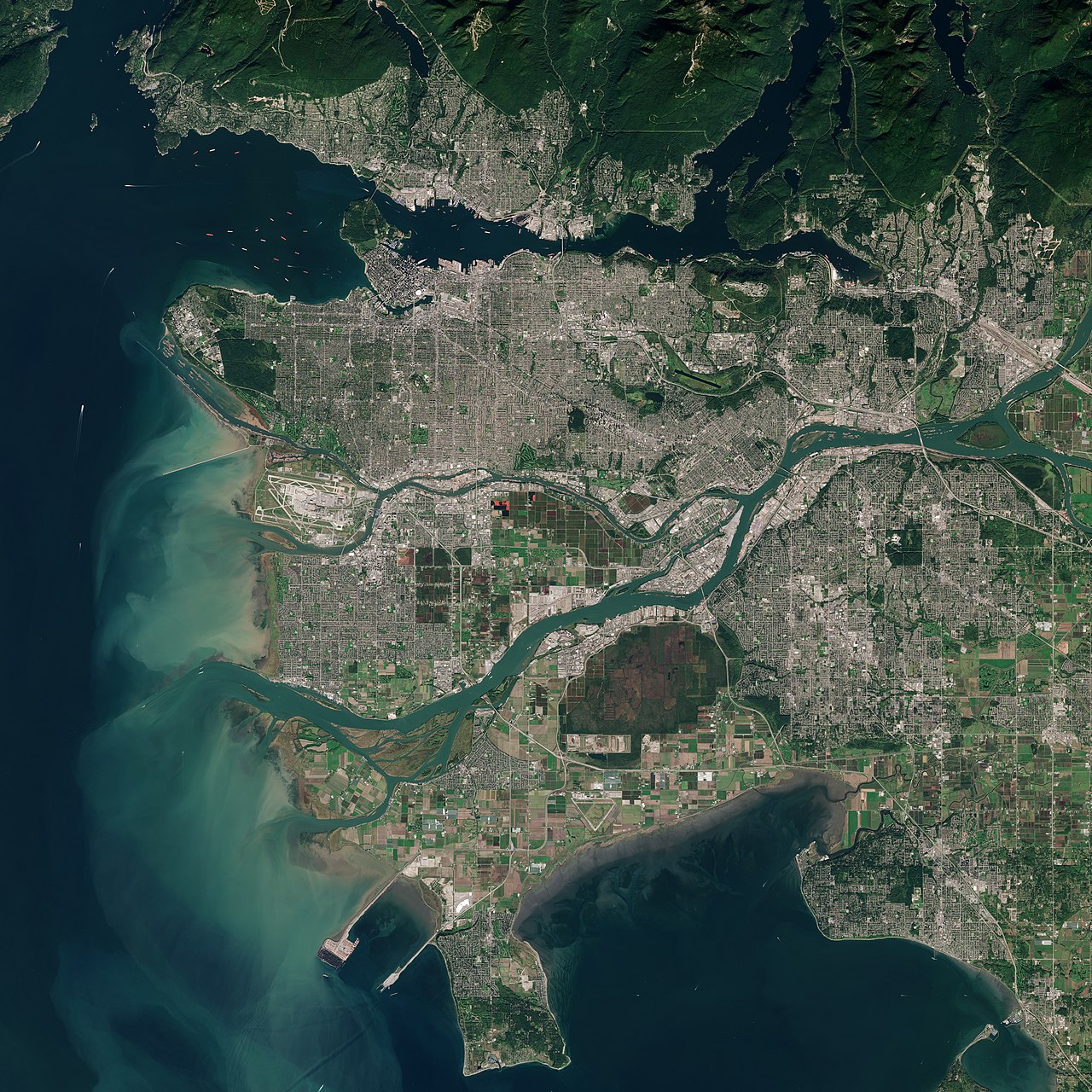
Vancouver is located on the Strait of Georgia, an inlet that is shielded from the Pacific Ocean by Vancouver Island. The 114.67 km² city area extends on the Burrard Peninsula, between the approximately 25 km long Burrard Inlet in the north and the Fraser River in the south. On the west side of the peninsula is English Bay. On its north coast, the Burrard Peninsula is further divided by another inlet, the approximately two kilometre long False Creek. On this smaller peninsula lie the city centre (Downtown) and Stanley Park, one of the largest urban parks in North America. On the west side of the park rises Siwash Rock, a prominent rock of volcanic origin. Vancouver's urban area includes flat and hilly terrain, with the highest point at 167 m above sea level, on Little Mountain in Queen Elizabeth Park.
The city is known for its scenic location. Towering mountains dominate the cityscape; these belong to the North Shore Mountains, the southernmost chain of the Coast Mountains. The three local mountains Grouse Mountain (1231 m), Mount Seymour (1449 m) and Mount Strachan (1454 m) are located on the north shore of Burrard Inlet directly opposite the city. On clear days, the volcano Mount Baker is visible in the southeast, which is located in the US state of Washington. The mountains on the Sunshine Coast to the northwest and Vancouver Island to the west and southwest round out the scenery.
Vancouver's neighbouring municipalities are West Vancouver to the northwest, North Vancouver to the north, the District of North Vancouver to the northeast, Burnaby to the east, and Richmond to the south. The University Endowment Lands to the west are a non-municipal area and form part of Greater Vancouver Electoral Area A.
Vegetation
The original vegetation of Vancouver and its suburbs was temperate rainforest, consisting of conifers and scattered maples and alders, interspersed with swamps (due to poor drainage even at higher elevations). The conifers were a mix of Sitka spruce, giant live trees, Western American hemlock, Douglas fir, and Pacific yew typical of the British Columbia coast. Only at Elliott Bay in Seattle were the mightiest trees of these species said to be taller than at Burrard Inlet and English Bay. The tallest trees in Vancouver's primary forest were in the Gastown area, where forestry first became active, and on the south shores of False Creek and English Bay (especially Jericho Beach). The majority of the trees in Stanley Park are secondary forest, but there are also some specially protected and designated trees that were worked by Indians in pre-European times (Culturally Modified Trees).
Many species of plants and trees that grow in Vancouver and the rest of the Lower Mainland have been imported here from other parts of North America and other continents. Several species of palm trees have adapted to the climate and are common, as well as a large number of other exotic trees such as monkey tail tree and fan maple, and flowers such as magnolias, azaleas and rhododendrons. Numerous rhododendrons have grown to enormous size, as have other species native to the colder climates of eastern Canada and Europe. Many of the city's streets have been lined with Japanese cherry trees donated by Japan since the 1930s.
Climate
Compared to the Canadian average, Vancouver's climate is unusually mild due to the influence of the Kuroshio Current. Winters are the fourth warmest in the cities recorded by the Canadian Department of the Environment, after Victoria, Nanaimo and Duncan (all located on nearby Vancouver Island). Its proximity to the sea creates a microclimate, with winter temperatures generally 2 to 4 °C warmer and summer temperatures 3 to 8 °C colder than inland. On average, the daily minimum temperature falls below freezing point on 46 days a year, and below -10 °C on only two days. The average daily highs in July and August are around 22 °C, but can rise to more than 26 °C in isolated cases.
Vancouver is considered a rainy city, with an average of 166 days of rain per year. Between November and March, rain can often fall for up to 20 days in a row, when the subtropical wind current known as the Pineapple Express brings in warm and humid air from Hawaii. As a rule of thumb, expect about 100 mm more precipitation per 100 meters of elevation. Snow falls far more frequently in the higher eastern and northern suburbs than in the city and at sea level. The annual snowfall is barely half a metre, but even light snowfall can lead to school closures and widespread traffic problems. This has to do with the fact that the snow is very wet due to the proximity to the coast, and the repeated rise and fall of the temperature above or below freezing point causes slippery roads to form.
There are up to six thunderstorms a year. These usually occur in late fall and winter and are sometimes accompanied by hail. The low number is due to the fact that the Strait of Georgia rarely warms up enough to create ideal conditions for thunderstorms.
| Vancouver, 1981-2010 | ||||||||||||||||||||||||||||||||||||||||||||||||
| Climate diagram | ||||||||||||||||||||||||||||||||||||||||||||||||
| ||||||||||||||||||||||||||||||||||||||||||||||||
| Monthly average temperatures and precipitation for Vancouver, 1981-2010
Source: | |||||||||||||||||||||||||||||||||||||||||||||||||||||||||||||||||||||||||||||||||||||||||||||||||||||||||||||||||||||||||||||||||||||||||||||||||||||||||||||||||||||||||||||||||||||||||||||||||||||||||||||||||||||||||||||||||||||||||||||
City breakdown
Vancouver is divided into 23 city districts, called neighbourhoods:
|
|


History
Pre-European settlement
See also: History of the First Nations
Archaeological evidence suggests that First Nations presence in the Vancouver area dates back approximately 4,500 to 9,000 years. At the time of the first encounter with Europeans, there were numerous settlements of the Musqueam, Squamish, Stó:lō, Tsawwassen and Tsleil'wau-tuth, who belong to the Coast Salish, along the lower Fraser River and the adjacent Pacific coast. These tribes between Vancouver Island and Washington State are closely linked by language and culture, but also by kinship and trade.
Although food procurement was based on gathering and hunting, they possessed a comparatively highly developed culture with strong social differentiation. Thus, similar to contemporary Europe, there existed a tripartite division of society into a dominant "nobility," simple tribesmen, and slaves. Their economic system rewarded hard work, the accumulation of wealth, and the social redistribution of that wealth, especially by the leading families, whose heads the Europeans called chiefs. Winter quarters in the Vancouver area consisted of large longhouses built from the wood of the giant live tree. Potlatch ceremonies were an important part of the social and spiritual life of these tribes.
European discovery and settlement
In 1791, Spanish Captain José María Narváez was the first European to sail along the coasts in the area that is now Vancouver. A year later, British Captain George Vancouver explored the Straits of Georgia, Burrard Inlet and Puget Sound. The first European to reach the area by land was Simon Fraser, a fur trader with the North West Company, who explored the entire length of the Fraser River, named after him, with his companions in 1808.
As a result of the Fraser Canyon Gold Rush (1858-1860) and especially the Cariboo Gold Rush (1861-1862), some 25,000 men, many from California, moved into the Fraser River watershed. The first permanent European settlement, the McCleery farm, was established in 1862 on the riverbank, east of the Musqueam winter camps in what is now the Marpole district. In 1863, the first sawmill began operations in Moodyville (now North Vancouver), establishing the traditional forestry industry. Other sawmills also sprang up soon after on the south shore of Burrard Inlet, then owned by Captain Edward Stamp. Stamp, who had been a logger around Port Alberni, had first established a sawmill at Brockton Point, at the eastern end of Stanley Park. But treacherous currents and reefs forced him to move the operation in 1865. Stamp's Mill was built on a site near what is now Gore Street.
The various sawmills in the area were major manufacturers of wood products for shipping. Many of the masts of the numerous windjammers and the ever-expanding ships of the Royal Navy were made of lumber from the Vancouver area. Among the many orders was one from the Chinese Emperor, who ordered dozens of huge beams for the Gate of Heavenly Peace in the Forbidden City in Beijing.
The settlement of Gastown was built right next to Stamp's Mill. It was named after John Deighton, whose nickname was "Gassy Jack" and who had opened a tavern there in 1867. In 1870, the colonial government of British Columbia had the settlement surveyed and officially named it Granville on March 1 in honour of Lord Granville, Minister to the Colonies. However, this name never caught on and the district is still called Gastown today.
The settlement was located on a natural harbour and for this reason was designated in 1885 by the Canadian Pacific Railway (CPR) as the western terminus of the transcontinental railway line instead of Port Moody, which was located 20 km to the east. Construction of the line had been one of the preconditions for British Columbia's entry into Canadian Confederation in 1871. CPR President William Cornelius Van Horne lobbied to change the name of the place to Vancouver because, in his opinion, people in the east of the country knew where Vancouver Island was, while Gastown or even Granville were completely unknown.
After the founding of the city
On April 6, 1886, the city was officially founded with the new name Vancouver. A blast of fire that got out of control due to a violent gust of wind almost completely destroyed the young city on June 13 of the same year. Within 45 minutes, over 1000 wooden houses were a prey to the flames, but rebuilding began the very next day. The first train pulled into Waterfront Station on the shores of Burrard Inlet on May 23, 1887. Thanks to the economic boom triggered by the railway, Vancouver recovered quickly and grew from a population of 5,000 in 1887 to 15,000 in 1892 and 100,000 in 1900.
In the first decades, large corporations dominated economic activity, as they possessed the necessary capital to drive the quantitative and qualitative growth of the city. Some industries developed, but the backbone of the city's economy was the exploitation of natural resources. Forestry dominated at first, and later export trade through the Port of Vancouver. The port particularly benefited from the opening of the Panama Canal in 1914 because it created a more direct export route to Europe. During World War I, about one-third of the inlet of False Creek was filled in to make room for more railway facilities, notably the Pacific Central Station of the Canadian Northern Railway (later Canadian National Railway).
The domination of the large corporations often led to violent workers' movements. The first major strike took place in 1903, when CPR railway workers demonstrated for recognition of their union. In 1918, Vancouver was the starting point of the first Canadian general strike. Other social movements such as feminists, moral innovators and temperance activists also exerted influence on city politics. In 1906, city officials tried unsuccessfully to shut down brothels on Dupont Street. During World War I and until 1921, a liquor prohibition law was in effect.
During the 1920s, Vancouver was repeatedly rocked by racially motivated riots, especially against Chinese and Japanese; various newspapers warned of an "Oriental menace."
On January 1, 1929, the territory of the City of Vancouver was expanded to its present extent with the incorporation of Point Grey and South Vancouver. It has since encompassed almost the entire western part of the peninsula between Burrard Inlet and the Fraser River. The population on that day was 228,193, making Vancouver the third largest city in the country. The economic boom of the 1920s ended abruptly with the Great Depression. Neighbouring North Vancouver and Burnaby were forced to declare bankruptcy, while Vancouver narrowly averted it. Thousands of young people travelled across Canada to Vancouver because they hoped to find work here. The communists found a large following in the poor quarters, organizing mass strikes on several occasions. Many members of the Mackenzie-Papineau Battalion, which fought in the Spanish Civil War, came from Vancouver.
The outbreak of World War II helped the region experience a rapid economic boom. Shipyards produced corvettes and minesweepers for the Royal Canadian Navy, and the Boeing plant in neighboring Richmond produced parts for B-29 bombers. In 1942, a few months after the attack on Pearl Harbor, the Canadian government considered Japanese-born Canadians a threat to national security, much as the Germans had been in World War I. The Canadian government also considered Japanese-born Canadians a threat to national security. Thus, Japanese Canadians were also dispossessed, rounded up in Hastings Park, and then interned in inland camps. It was not until 1988 that the government officially apologized and paid compensation.
Since 1950
In December 1953, CBUT, the first television station in Western Canada, began broadcasting. Several new bridges created better transportation links. Before the war, the Second Narrows Bridge (1925) and the Lions Gate Bridge (1938) had already been built to the north shore of Burrard Inlet. This was followed in 1957 by the Oak Street Bridge over the Fraser River to Richmond and in 1960 by the Ironworkers Memorial Second Narrows Crossing over Burrard Inlet.
Two new universities were founded in the suburb of Burnaby, both of which now have branches in Vancouver and complement the University of British Columbia, which was founded in 1908: The British Columbia Institute of Technology began in 1960, followed by Simon FraserUniversity in 1965. Residents of the Chinese-influenced Strathcona neighbourhood formed a protest movement in the late 1960s and prevented the demolition of this neighbourhood, which was to make way for a planned highway. The protests led to a rethinking of transportation policy and, in 1980, the banning of further freeways on city property. In 1971, Greenpeace was founded in Vancouver, today one of the world's most important environmental protection organizations. The continued growth of Vancouver International Airport on Sea Island made it necessary to build another bridge over the Fraser River, the Arthur Laing Bridge was inaugurated in 1976.
After Vancouver won the bid to host the 1986 World's Fair, a building boom began in the city that, with a few brief interruptions, continues to this day. In 1983, BC Place Stadium was opened, Canada's first covered stadium. This was followed in January 1986 by the first line of the SkyTrain, an elevated train connecting Vancouver to the suburbs. Other prominent buildings that were built in anticipation of Expo 86 and have shaped the cityscape ever since are Science World, Canada Place and the Plaza of Nations.
The World's Fair, which ran from May to October 1986 and was the last to be held in North America, proved to be a great success, attracting over 20 million visitors. The exhibition site on the north bank of False Creek had previously been a vast industrial wasteland and was sold to Hong Kong-born entrepreneur Li Ka-shing after the exhibition ended. He implemented one of the largest urban development projects in North America, and False Creek was transformed within a few years into a high-density and attractively located residential area on the edge of downtown. By the 1970s, Granville Island, a peninsula located in False Creek, had already been transformed from an industrial zone to a popular shopping and cultural district. This sustainable urban planning increased the quality of life in the region.
In 1998, the National Olympic Committee of Canada decided to bid to host the 2010 Winter Olympics. In the internal Canadian elimination, Vancouver received the most votes ahead of Québec and Calgary. On February 22, 2002, in a (legally non-binding) municipal referendum, 63.9% of participating voters approved the bid. Vancouver won the bid at the 115th IOC Session in Prague on 2 July 2003, beating Pyeongchang and Salzburg.
Since then, the city has used the improved transport infrastructure for the Olympic Games for targeted urban development at nodes. The stops on the Canada Line, which connects Vancouver's waterfront with Richmond and the airport, are becoming centers of dense development and local amenities in the city and in Richmond. While the organizing committee was able to break even for the Games, this did not include the cost of building the new infrastructure for the Olympics, which has been a significant drain on the City of Vancouver's budget ever since. The province's debt also increased by CAD 24 billion within ten years as a result of the Games.
The immigration policy of the USA, which has hindered American companies in recruiting employees since Donald Trump's election to the presidency, has led them in many cases to switch to Canada and in particular to Vancouver. For example, Microsoft established its Microsoft Canada Excellence Centre (MCEC) in Vancouver with 750 employees. By 2020, 50,000 new technology jobs are expected to be created there, and Vancouver is now the leading Canadian city for startups. However, this is leading to rapidly growing real estate prices and rents. Since 2015, Amazon has been acquiring properties and building new ones to accommodate at least 5,000 employees.


Related articles
Author
AlegsaOnline.com Vancouver, British Columbia Leandro Alegsa
URL: https://en.alegsaonline.com/art/104179
Sources
- www12.statcan.gc.ca : www12.statcan.gc.ca/census-recensement/srvmsg-i/srvmsg404.html
- statcan.gc.ca : "Population size and growth in Canada: Key results from the 2016 Census"
- www12.statcan.gc.ca : Census Profile, 2016 Census - Vancouver, City Census subdivision, British Columbia Province
- brookings.edu : "Global city GDP 2014"
- bcstats.gov.bc.ca : "Province of British Columbia and Greater Vancouver Transit Authority (TransLink) Facts 2008"
- www12.statcan.ca : "2006 Census: Population by mother tongue - cities"
- city.vancouver.bc.ca : "City Facts 2004"
- home.istar.ca : "Stó:lo Culture - Ideas of Prehistory and Changing Cultural Relationships to the Land and Environment"
- climate.weather.gc.ca : "Daily Data Report for October 1898"
- climate.weather.gc.ca : "1981 to 2010 Canadian Climate Normals"