Uruguay
![]()
The title of this article is ambiguous. For other meanings, see Uruguay (disambiguation).
Template:Infobox State/Maintenance/NAME-German
Uruguay (Spanish![]() ; officially República Oriental del Uruguay [reˈpuβlika oɾjenˈtal del uɾuˈɣwaj] "Eastern Republic of Uruguay") is a country in the Southern Cone of South America. It is the smallest Spanish-speaking country in South America. Uruguay is bordered by Brazil to the north, the Atlantic Ocean to the east, the Río de la Plata to the south, and Argentina to the west (separated by the Río Uruguay).
; officially República Oriental del Uruguay [reˈpuβlika oɾjenˈtal del uɾuˈɣwaj] "Eastern Republic of Uruguay") is a country in the Southern Cone of South America. It is the smallest Spanish-speaking country in South America. Uruguay is bordered by Brazil to the north, the Atlantic Ocean to the east, the Río de la Plata to the south, and Argentina to the west (separated by the Río Uruguay).
After the arrival of European settlers, the horses and cattle abandoned by the Spaniards developed into large herds on the vast grasslands of the pampas, which formed the basis of the country's economic wealth. Uruguay is now one of the most stable, democratic and prosperous countries in Latin America. The political and economic transformation has made considerable progress in recent years.
Origin of the name
The full name of the country of Uruguay is "Eastern Republic of Uruguay". In the Guarani language, from which the name originates, Uruguay has different meanings depending on the interpretation:
- "River of the colorful birds" after Juan Zorrilla de San Martín
- "Snail River" (arugua "snail", y "water").
- "River of the Uruland" after Félix de Azara. Urú = bird name, gua "land", y "water".
- "River of Food Carriers" based on an old document by Jesuit Lucas Marton.
Geography
Location
Uruguay is the second smallest country in South America after Suriname. With an area of 176,215 square kilometres (of which about 2,600 square kilometres is water), it is the size of Austria and Hungary combined, or about half the size of Germany. Uruguay shares a 985 km border with Brazil to the north and a 579 km border with Argentina to the west. The coast is 660 km long.
Landscape
Uruguay is the geographical extension of the Argentinean pampas. The south of the country is therefore almost flat. Along the Río Uruguay there are extensive swampy plains that are frequently flooded.
The centre is a low tableland, which rises in chains of hills up to 514 m above sea level. Strata and hardscapes give the country an overall hilly character. The coast is strongly indented in the southeast by shallow beach lakes and lowlands. In the north the country is covered with hill ranges, e.g. the Cuchilla de Haedo or also the Cuchilla Grande in the northeast, which however only insignificantly exceed the height of 500 m. The highest elevation of Uruguay is the Cuchilla de Haedo. The highest elevation of Uruguay is the Cerro Catedral with 514 m above sea level, further elevations are the Cerro de las Ánimas (501 m), the Cerro Ventana (420 m) and the Cerro Colorado (299 m). The lowest point is at sea level. Overall, the country is very flat, with only ten percent of the land area higher than 200 meters above sea level. The soil is generally fertile and is therefore used almost everywhere for agriculture. Forests make up only a small part of the country's area, about five percent.
Climate
The climate is subtropical in the north and temperate in the south. In the coastal regions, the temperatures are similar to the climatic conditions of the coastal regions of southern France, northern Italy and northern Spain, with clearly defined thermal seasons. The average annual temperature there is 16.5 °C. The warmest month is January, with about 22 °C, while June is the coolest month, with an average of 10 °C. In the interior, the mean annual temperature is slightly higher, mainly due to the higher summer temperatures.
The absolute temperature extremes in Montevideo are 43 °C and -5 °C, frost can occur there - although rarely - from May to October.
Throughout the country - in contrast to the Mediterranean region - precipitation falls all year round (east side climate), averaging 1,000 mm/year, and up to 1,400 mm/year in the wettest areas in the north. Only the region around Punta del Este has slightly less precipitation, with just under 1,000 mm/year.
The winter half-year is generally somewhat drier than the summer half-year, with the wettest month being March. Measurable precipitation falls on about 100 days a year in Montevideo.
The average annual sum of sunshine duration in Montevideo is 2,800 hours.
Relative humidity varies between 70 and 75 percent nationwide, with peaks of 80 percent in July and 65 percent in January. It is quite common for the humidity to drop from 90 percent at sunrise to 45 percent in the afternoon.
In winter, the country is often hit by very strong, cold southwesterly winds known as pamperos, which devastate the coastal regions of the country. Cold blasts are usually accompanied by southeast winds, known as sudestadas, which can cause widespread flooding in the La Plata region. Overall, easterly to northeasterly winds predominate.
Although precipitation is distributed relatively evenly throughout the year, extreme irregularities can be observed time and again. There were long dry periods such as 1891-1894, 1916-1917, 1942-1943, 1964-1965 and 1988-1989, on the other hand the years 1914, 1959, 1983 or 1992 were extremely rainy. Since there are no mountains as natural barriers, the country is very susceptible to rapid weather changes, especially when a long dry period is followed by heavy rains.
| Monthly average temperatures and precipitation for Montevideo
Source: Temperature, sunshine hours and rainy days: The International Climate Index, Precipitation: MSN Weather, Montevideo, URY | ||||||||||||||||||||||||||||||||||||||||||||||||||||||||||||||||||||||||||||||||||||||||||||||||||||||||||||||||||||||||||||||||||||||||||||||||||||||||||||||||||||||||||||||||||||||||||||||||||||||||||||||||||||||||||||||||||||||||||||||||||||||||||||
Major cities
Montevideo, the capital, with almost 1.5 million inhabitants, is the only major city as well as the most important port city in the country. Not only is almost half of the population concentrated there, but also the country's industry and trade, which is why Uruguay is often jokingly referred to as "a city with a few farms in the hinterland". Montevideo thus represents a primacy city, it is also a center of Latin American politics (seat of ALADI and the Secretariat of Mercosur). The city is also considered very safe by Latin American standards.
The cities of Salto (104,028 inhabitants) and Paysandú (76,429 inhabitants), located on the border with Argentina on the Río Uruguay, are competing for the title of the second most important city. Both cities are characterized by the agricultural industry, Salto also has a share in the important hydroelectric power plant Salto Grande. Other towns are Las Piedras (pop. 71,268), Rivera (pop. 64,485), Maldonado (pop. 62,592), Tacuarembó (pop. 54,757), and Melo (pop. 51,830). The country's best-known seaside resort, Punta del Este, is about 140 km east of Montevideo. In the high summer months of December to February, the city is the meeting place of the sophisticated South American world, when the population swells from 30,000 to over 200,000 people and international sailing regattas, fashion shows and marathons take place.
See also: List of cities in Uruguay
Rivers and waters
The country is very rich in water. The water network can be divided into two large basins: the Inner Basin and the Atlantic Basin. The Atlantic basin is fed by relatively short rivers that flow into the sea. It can in turn be divided into two basins: that of the Río de la Plata (to the west) and that of the Merin Lagoon (to the east). The inner basin consists of watercourses that flow into the Uruguay. Its most water-rich tributary, the Río Negro, flows through the country from east to west and in turn forms a large basin.
The largest river is the Río Uruguay, which has a total length of 1790 km, rises in the southern Brazilian coastal mountains and, together with the Río de la Plata, forms the western border of the country. The most important tributary is the Río Negro, which crosses Uruguay from northeast to southwest over a distance of 750 km and is dammed in the center of the country to form the 1140 square kilometer lake Rincón del Bonete. This reservoir was created by the construction of the dam on the Río Negro to generate electrical energy. It is located halfway down the river, behind the Dr. Gabriel Terra Dam, completed in 1945.
The Río de la Plata empties into the Atlantic Ocean at the world's largest estuary. The Río Uruguay is navigable along the entire western border of the country. It supplies the entire country with drinking water, as do the two large reservoirs on the Río Negro (Rincón del Bonete and Paso del Palmar) in central Uruguay. Other important lakes are the Laguna Merín in the east of the country, the Embalse de Salto Grande (area: 783 square kilometres) on the Río Uruguay and the Baygorria reservoir on the Río Negro. In addition, the Laguna del Sauce, the Laguna José Ignacio, the Laguna Garzón, the Laguna de Rocha, the Laguna de Castillos and the Laguna Negra are located on the southeastern coast.
Uruguay's abundance of water is not only found above ground. The Acuífero Guaraní, which extends beneath the land areas of Uruguay, northern Argentina, Paraguay and southern Brazil, contains an estimated 37,000 cubic kilometres of groundwater, making it one of the largest freshwater reservoirs anywhere.
Following a referendum in October 2004, the right to water was enshrined in Uruguay's constitution. This had to be amended and henceforth include a guarantee that access to drinking water and sanitation is a fundamental human right and must be guaranteed by the state. Uruguay is thus the first country in the world in which the right to water was given constitutional status by plebiscite.
See also: List of rivers in Uruguay
Mineral Resources
Uruguay is relatively poor in mineral resources, has no oil deposits of its own, and mineral deposits are also only to be found in isolated cases. However, various bulk raw materials are mined, such as limestone for the production of cement, or (especially in the south of the country) clays and clay-rich silts for bricks. Besides dolomite and marble, the so-called "black granite" is also quarried as natural stone, especially in the southeastern departments. However, only in the Soca anticline is it genuine granite (with a porphyritic structure and a dark, grey-green matrix). Otherwise, basic gangue rocks, such as medium- to fine-grained dolerites and microgabbros, are marketed under this (misleading) name.
The industrial minerals feldspar, beryl and quartz are extracted from pegmatite veins in the departments of Colonia and Florida. The latter is elementary for the production of glass. Kaolinite for porcelain is found at Blanquillo, and montmorillonite at Bañado de Medina. In the department of Colonia talc is even mined underground; in the department of Río Negro gypsum is found. On the coast of the Departamento Rocha, placer deposits of the important titanium ore ilmenite have accumulated.
In the northeast of the country, there are extensive basaltic lava beds whose bubble spaces are often filled with agate and amethysts. However, only in the department of Artigas they are extracted and processed into jewelry since 1972.
In the area between Minas and Pan de Azúcar (Lavalleja) there are some small, mostly insignificant deposits of lead and zinc ores (subordinately also copper). Of these, La Oriental was exploited from 1850 to 1870 and from 1936 to 1939. The iron ores magnetite and hematite are associated with highly metamorphic banded ore intercalated in granitic gneisses, but these were only mined at Valentines (Florida). Other (partly manganese-bearing) ribbon ore is found at Isla Cristalina de Rivera in the north of the country, but has never been exploited. However, the only producing gold mine in the country is located there, at Minas de Corrales.
Flora
Of the once mighty, impenetrable bush forests, only a few remnants remain. The forest patches, mostly at the lower reaches of the rivers, today occupy a total of only 5 percent of the national territory. Characteristic of the form of vegetation predominant in Uruguay are tall prairie grasses. Native hardwood trees include urunday, lapacho, carob, quebracho, jacaranda, and acacia. Other flowering plants include mimosa and kapok trees. Palm trees thrive in the southeast and in the valleys of the central region and in northern Uruguay. In the coastal areas, pines and eucalyptus trees have been planted to protect against further sand encroachment. The widespread cypress, oak, cedar, mulberry and magnolia trees have also been introduced from outside.
Fauna
Populations of cougars, seals, tapirs, chahas and nandus are now severely depleted. Deer, wild boar, otters (including the endangered giant otter up to 2.20 m long), foxes, armadillos, anteaters and various rodents are among the most common mammals. Among the bird species, vultures, burrowing owls, turkeys, parakeets, cardinals, hummingbirds, swans (including the very rare black-necked swans) and wild ducks are worth mentioning. The reptile fauna includes lizards, turtles and rattlesnakes. The range of caimans is restricted to the upper reaches of the Uruguay River. Uruguay has (after Alaska) the second largest colony of seals and sea lions, which are resident on Isla de Lobos (= Seal Island, located off Punta del Este). Whales and dolphins are also sighted; sharks on the high seas, but never near the coast.
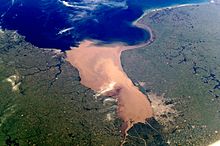
Río de la Plata
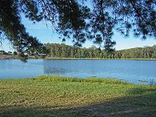
Lago de la Juventud near Iporá in Tacuarembó
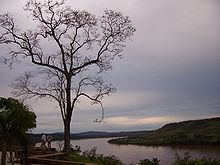
River Uruguay
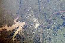
Satellite image of the Salto Grande
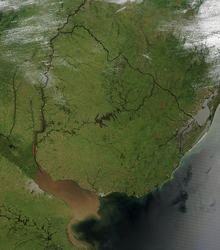
Satellite image of Uruguay
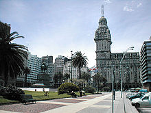
Montevideo center
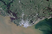
Satellite image of Montevideo
Questions and Answers
Q: What is the official name of Uruguay?
A: The official name of Uruguay is the Oriental Republic of Uruguay.
Q: What language is spoken in Uruguay?
A: Spanish is the language spoken in Uruguay.
Q: What is the capital and largest city in Uruguay?
A: Montevideo is both the capital and largest city in Uruguay.
Q: Which countries border Uruguay?
A: Brazil and Argentina are both countries that border Uruguay.
Q: Is there any country smaller than Uruguay in South America?
A: Yes, Suriname is a smaller country than Uruguay located in South America.
Q: What type of terrain can be found in most parts of Urugay?
A: Most parts of Urugay have flat terrain with many farms located throughout the countryside.
Q: How did Urugay become an independent nation?
A: In the 1810s, it was part of a Federal League called Banda Oriental which was fought over by Portugal and Spain Empires, but eventually Argentina and Brazil took control leaving Urugay as an independent nation.
Search within the encyclopedia