
Uluṟu‑Kata Tjuṯa National Park
Protected area in Australia’s Northern Territory, encompassing the sandstone monolith Uluṟu and the dome formations of Kata Tjuṯa, central to Anangu culture and recognised for combined natural and cultural values.
Uluṟu‑Kata Tjuṯa National Park is a remote protected area in Australia’s Northern Territory that surrounds two of the continent’s best‑known geological features: Uluṟu (often called Ayers Rock) and Kata Tjuṯa (The Olgas). The park lies roughly 440 kilometres south‑west of Alice Springs and combines striking desert scenery with deep cultural significance for the Anangu people. For official visitor information see the park website.
Image gallery
10 Images
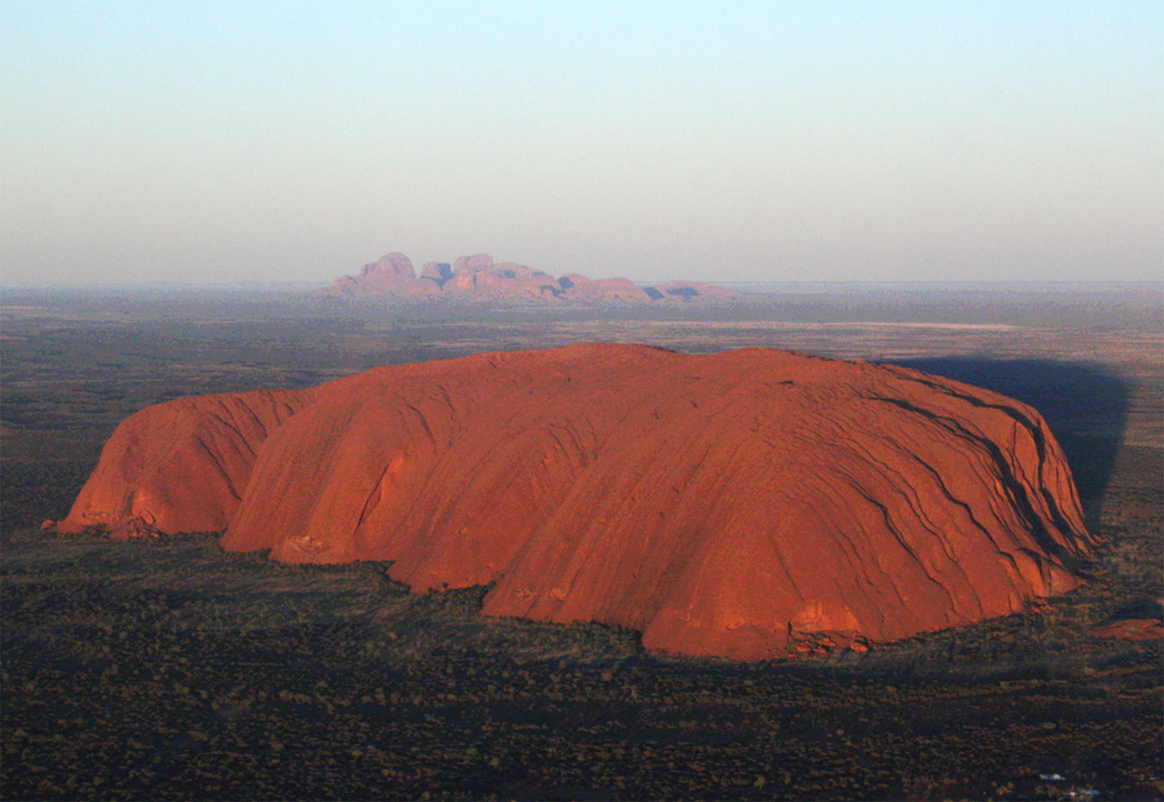


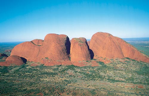
Location and landscape
The park occupies arid country of red sandplains, spinifex grasslands and low shrublands. Uluṟu is a single, prominent sandstone monolith that changes colour with light and weather. Kata Tjuṯa consists of a group of large, rounded domes several kilometres to the west. Both features stand out across the surrounding flatlands and are visible from long distances, forming important navigational and cultural landmarks in central Australia.
Geology and ecology
Geologically, Uluṟu and Kata Tjuṯa have different compositions: Uluṟu is largely a coarse sandstone slab, while Kata Tjuṯa is made up of conglomerate rock—cemented fragments of various rock types. These landforms were produced by long periods of sedimentation, burial and erosion. The park supports desert‑adapted plants such as spinifex and mulga and a range of animals including reptiles, small mammals and many bird species adapted to arid conditions.
Cultural significance
The park is the traditional country of the Anangu, who maintain strong spiritual connections to the landscape through Tjukurpa (creation law and stories). Many sites within the park are sacred and subject to cultural protocols; interpretive materials and cultural presentations at the visitor centre explain aspects of Anangu history, law and traditions. Visitors are asked to respect those protocols and the living cultural landscape. Background information on the wider national context is available on general Australia information pages.
History, management and protection
Management is a partnership between the Anangu traditional owners and Parks Australia under joint management arrangements that recognise traditional ownership while providing conservation and visitor services. The park is recognised internationally for both natural and cultural values and has World Heritage status. Practical regional information and services can be obtained from Northern Territory resources and regional centres such as Northern Territory portals and Alice Springs visitor services.
Visiting and conservation guidance
The park offers walking tracks, guided cultural programs, and sunrise and sunset viewing areas. Certain activities are restricted to protect cultural sites and fragile environments; climbing Uluṟu is no longer permitted and visitors should follow signage, use designated trails and learn about local customs. Responsible visitation supports conservation of desert ecosystems and the cultural heritage entrusted to the Anangu people.
- Key features: the Uluṟu monolith, the Kata Tjuṯa domes, desert flora and fauna.
- Significance: a living cultural landscape with outstanding natural and cultural values.
- Advice: respect cultural protocols, follow park rules and use official visitor resources.
Questions and answers
Q: What is Uluṟu-Kata Tjuṯa National Park?
A: Uluṟu-Kata Tjuṯa National Park is a national park in Australia.
Q: Where is Uluṟu-Kata Tjuṯa National Park located?
A: Uluṟu-Kata Tjuṯa National Park is located in the Northern Territory of Australia, 440 kilometres south-west of Alice Springs.
Q: What are the two rock formations that the national park surrounds?
A: The national park surrounds two huge rock formations: Uluṟu (Ayers Rock) and Kata Tjuṯa (The Olgas).
Q: What is the distance between Uluṟu-Kata Tjuṯa National Park and Alice Springs?
A: The distance between Uluṟu-Kata Tjuṯa National Park and Alice Springs is 440 kilometres.
Q: What is Uluṟu and what is Kata Tjuṯa?
A: Uluṟu is a huge rock formation in Uluṟu-Kata Tjuṯa National Park, also known as Ayers Rock. Kata Tjuṯa is another huge rock formation in the park, also known as The Olgas.
Q: What is the geographic location of Uluṟu-Kata Tjuṯa National Park?
A: Uluṟu-Kata Tjuṯa National Park is located in the Northern Territory of Australia.
Q: What surrounds Uluṟu-Kata Tjuṯa National Park?
A: Uluṟu-Kata Tjuṯa National Park surrounds the two huge rock formations of Uluṟu and Kata Tjuṯa.
Related articles
Author
AlegsaOnline.com Uluṟu‑Kata Tjuṯa National Park Leandro Alegsa
URL: https://en.alegsaonline.com/art/102711
Sources
- environment.gov.au : "CAPAD 2012 Northern Territory Summary (see 'DETAIL' tab)"
- environment.gov.au : "Uluṟu-Kata Tjuṯa National Park Notes: Non-Aboriginal history"
- whc.unesco.org : "Uluṟu-Kata Tjuṯa National Park"
- environment.gov.au : "Culture, history and World Heritage"
- sacred-destinations.com : "Uluru (Ayers Rock)"
- environment.gov.au : "The creation period"
- australiaforeveryone.com.au : "The Olgas (Kata Tjuta), NT"
- learnline.cdu.edu.au : "Tjukurpa"
- environment.gov.au : "Uluru - Kata Tjuta National Park: European contact"
- ntlis.nt.gov.au : "Kata Tjuta / Mount Olga"
- environment.gov.au : "Park history: Growing tourism in the park" · web.archive.org
- environment.gov.au : "Park history: Developing a National Park"
- environment.gov.au : "Park history: Development of Aboriginal ownership and joint management"
- clc.org.au : "The Aboriginal Land Rights Act"