Tyrrhenian Sea
A major arm of the western Mediterranean off Italy’s west and south coasts, the Tyrrhenian Sea is known for its islands, volcanic activity, important ports, and ecological and historical significance.
Overview
The Tyrrhenian Sea (Italian name Mar Tirreno) is a large basin of the Mediterranean Sea located off the western coast of the Italian Peninsula. It occupies a central position in the Mediterranean, bounded by several Italian regions and a number of significant islands. Its waters have played an important role in regional trade, navigation and cultural exchange since antiquity.
Image gallery
10 Images


Geography and borders
The sea is enclosed on the west by the large islands of Corsica and Sardinia and on the south and east by parts of the Italian mainland and Sicily. Coastal regions that meet the Tyrrhenian Sea include:
- Tuscany (north-east)
- Lazio (central east)
- Campania (south-east)
- Basilicata (small coastal stretch)
- Calabria (toe of the peninsula)
- Sicily (southern border)
Physical characteristics
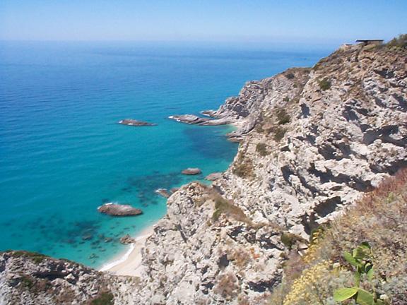
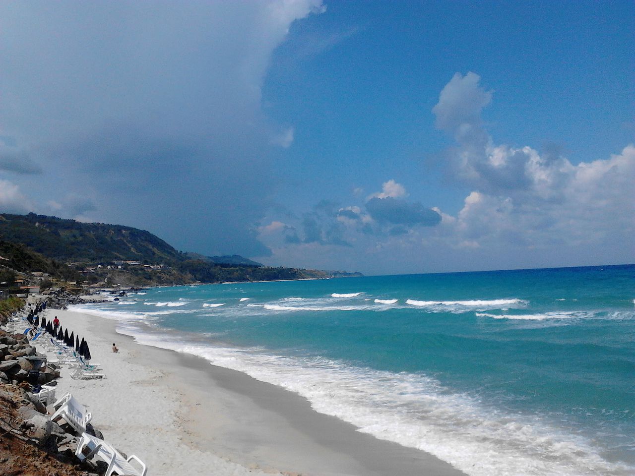
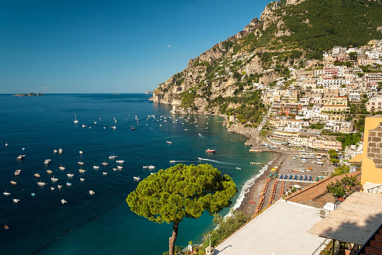
The Tyrrhenian Sea contains a mix of shallow coastal shelves and deeper basins farther offshore. Its coastline is indented with gulfs and bays and pierced by many archipelagos, including volcanic island groups. Sea conditions are influenced by Mediterranean circulation patterns and local winds, making the region attractive for maritime activity and recreation.
History and name
The sea’s name ultimately comes from Greek references to the people known as the Etruscans, who inhabited parts of the adjacent mainland in antiquity. From the Roman era onward, the waters of the Tyrrhenian have been central to commerce, warfare and cultural contact across the central Mediterranean.
Uses and importance
Coastal communities rely on the Tyrrhenian Sea for fisheries, tourism and transport. Important ports and coastal cities along its shores support passenger ferries, cargo shipping and recreational boating. The marine environment sustains diverse habitats, while nearby volcanic islands and coastal landscapes draw scientific interest and visitors.
Notable features and environmental concerns
The area is geologically active, with a history of volcanic eruptions and earthquakes that have shaped islands and seafloor topography. Human pressures — including overfishing, pollution and coastal development — have motivated conservation measures and marine protected areas to preserve biodiversity and the sea’s long-term resources.

Name
The name of the sea is derived from the Greek name for the Etruscans, who were called Tyrrhenoi in ancient Greek. According to Greek tradition, the Etruscans, who lived roughly in the area where Tuscany is located today, were led to their later settlement area by the prince Tyrrhenus from Lydia. In the Latin of the Roman Empire, the sea was the Mare Tyrrhenicum. The name and its variations are also used by the riparians themselves, so the French name of the sea is Mer Tyrrhénienne, the Italian Mar Tirreno. In Ligurian it is Mâ Tirren, in Sicilian and Corsican it is Mari Tirrenu, in Sardinian it is Mare Tirrenicu.
Geography
Location
The Tyrrhenian Sea lies between the Italian mainland to the east, the islands of Sardinia and Corsica to the west, Sicily to the southeast, bordering the Ligurian Sea to the north and the open Mediterranean Sea to the south. On the Italian mainland it borders the regions of Tuscany, Lazio, Campania, Basilicata and Calabria. The sea covers an area of 231,000 km².
The exact boundaries run according to the definition of the IHO:
f1![]() Map with all coordinates: OSM | WikiMap
Map with all coordinates: OSM | WikiMap
- In the Strait of Messina from the northernmost point of Cape Paci (38° 15′ 27″ N, 15° 42′ 52″ E38.257388888915.7145277778) to the easternmost point of Sicily at Cape Pelore (38° 16′ 3″ N, 15° 39′ 11″ O38.267388888915.6530833333).
- To the southwest (of the Strait of Sicily) from the westernmost point of Sicily (Cape Lilibeo) (37° 48′ 7″ N, 12° 25′ 27″ O37.802083333312.4241111111) to the southernmost point of Sardinia (Cape Teulada) (38° 51′ 51″ N, 8° 38′ 44″ O38.86405555568.64547222222).
- In the Strait of Bonifacio from the westernmost point of Capo Testa in Sardinia (41° 14′ 15″ N, 9° 8′ 17″ O41.23758333339.13808333333) to the southwesternmost point of Cape Feno (41° 23′ 31″ N, 9° 5′ 46″ O41.39186111119.09602777778) in Corsica.
- North: A line from Cap Corse (43° 0′ 37″ N, 9° 23′ 0″ E43.01016666679.38333333333) to Tinetto (44° 1′ 25″ N, 9° 51′ 3″ O44.02361111119.85083333333), through the islands of Tino and Palmaria to Saint Pietro Point (44° 2′ 53″ N, 9° 49′ 57″ O44.04797222229.83241666667) on the Italian mainland coast.
Origin
The Tyrrhenian Sea is much younger than the rest of the Mediterranean Sea in terms of geological history. It opened as a backarc basin probably 7 million years ago in the Miocene. The movement ended about 3 million years ago in the Pliocene. At the time it began to open, the Corsican-Sardinian continental block was adjacent to the Adriatic Plate. Eurasian and African plates pushed the Corsican-Sardinian block together in a north-south direction, as a result the Adriatic plate rotated counterclockwise and the Tyrrhenian Sea opened in an east-west direction.
The crust beneath the Tyrrhenian Sea has structures of true oceanic crust, but this has a limited volume. The deepest layers consist of stretched continental crust in the very largest part of the sea. The thin crust of the Tyrrhenian Sea borders the Calabrian subduction zone to the east and is sandwiched by the Adriatic and African plates to the north and south. Under the Tyrrhenian Sea lies the subducted part of the Ionian Plate.
In the last 13,000 years, the water level in the Tyrrhenian Sea has risen by 67 metres. Regular measurements of the rise have been taken since 1884. The average rise was 1.2 millimetres per year between 1897 and 1942, 1.54 millimetres per year on average between 1931 and 1971, and 1.6 millimetres per year until the end of the 1980s.
Shape and hydrology
Shape
The sea has a roughly triangular shape. The maximum depth is unclear; indications are usually around 3600 meters, but range from about 3,400 to 3,840 meters. The continental shelf is narrow and reaches widths of 10 to 40 kilometres. Of the 231,000 km² total area, the continental shelf accounts for 14,800 km² and the continental slope for another 48,600 km². The rest of the area is taken up by deep-sea basins. The landform can be divided by tectonic and magnetic criteria approximately at 41 degrees north latitude. South of this line, the crust is much thinner and volcanic irregularities are much more pronounced.
In the northern part of the sea, the Canale di Corsica forms the main link between the Tyrrhenian Deep Sea Basin and the Ligurian-Provençal Basin to the north. The deep-sea channel is about 100 kilometres long and only about 30 kilometres wide at its narrowest point between the Tuscan shelf with the islands of Capraia and Corsica. It reaches depths of 460 metres. The northern Tyrrhenian Sea does not get deeper than 2000 meters. The western half, the so-called Corsica Basin, is comparatively shallow. On the central ridge are the islands of Elba, Montecristo, Capraia and Pianosa. On the coast lies the Tuscan shelf, again comparatively flat. The seamounts Etruschi and Cialdi lie at the transition to the deeper southern Tyrrhenian Sea. The earth's crust is about 25 kilometres thick in the northern Tyrrhenian Sea.
The southern part of the Tyrrhenian Sea probably consists partly of basaltic ocean crust. The crust is about 30 kilometres thick near Sardinia in the west and thins to values between five and ten kilometres towards the west. The crust is particularly thin here in the central area beneath the Vavilov and Marsili deep-sea mountains, which also lie above a comparatively soft mantle. Similar characteristics are found under Ischia. The Tyrrhenian Sea thus has the thinnest crust in the Mediterranean. The soil there is complex, consisting of numerous slopes and comparatively small, deep plains. These are surrounded by deep sea mountains, which can also be located in the middle of the plains. In addition, there is a variable and complex coastline. From the northern coast of Sicily, the seabed drops steeply into a basin that is one of the deepest parts of the sea. On the Sicilian coast towards the Italian peninsula, the slope is less pronounced.
The southern Tyrrhenian Sea shows numerous magmatic bottom structures that can rise up to almost three thousand meters. These include several deep-sea mountains of volcanic origin such as Vavilov and Marsili. Marsili rises 2600 meters above the seafloor and seems to consist of the oldest rocks. The Lipari Islands, located north of Sicily, are younger than the Tyrrhenian Sea and only about one million years old. They formed due to magma movements that occurred when the Ionian Plate slid under the Tyrrhenian Sea. The island of Ustica lies on continental crust in the transition zone between the Tyrrhenian Ocean crust and the surrounding plates and is of volcanic origin.
Hydrology
As the entire Mediterranean is only connected to the Atlantic via the narrow Strait of Gibraltar, the tides are hardly pronounced. The current conditions in the sea are determined almost exclusively by longer-lasting seasonal currents, which are, however, comparatively weak. Stronger currents occur mainly in the connections to other seas. The Strait of Bonifacio has strong currents, as does the Strait of Messina. In the latter, these are particularly pronounced because the tides in the Tyrrhenian Sea to the north and the Ionian Sea to the south are opposite, so that high tide in one sea meets low tide in the other, and the direction of the current changes with the tides.
The water in the Tyrrhenian Sea flows in principle at all depths from the south to the north. Also compared to other basins of the Mediterranean Sea, the Tyrrhenian Sea is characterized by distinct barotropic conditions in which individual water layers circulate similarly. In winter, there is a clear counterclockwise circulation in all water layers. In spring and summer this weakens, and in summer a surface current in the opposite direction develops. Throughout the year, water flows from the Tyrrhenian Sea towards the north into the Ligurian Sea at all depths.
Surface water comes with the Algerian Current from the western open Mediterranean Sea. It rotates counterclockwise in the Tyrrhenian Sea before flowing into the Ligurian Sea. It consists of Modified Atlantic Water with a temperature of about 16.5 degrees and a salinity of 36.5.
The middle water region at a depth of about 200 to 600 metres consists of Mediterranean Intermediate Water (MIW), which has a temperature of 14.5 degrees and a salinity of 38.75. It originates in the eastern Mediterranean Sea on the Levant and flows northwards from the open Mediterranean Sea on the Sardinian coast into the Tyrrhenian Sea, where it forms an eddy. On the seabed, West Mediterranean Deep Water (WMDW) flows into the Tyrrhenian Sea from the Golfe du Lion at a depth of about 1500 to 3000 metres in spring.
Large rivers that flow into the sea are the Arno and the Tiber, whereby the Tiber has the greater water volume on average, but the Arno has clearly more pronounced differences between high and low levels and can at times far exceed the Tiber in water volume. On average, 1225 m³/s of fresh water flows directly into the sea.
Climate
This part of the Mediterranean has a subtropical Mediterranean climate with a hot, dry summer and a mild, rainy winter. In general, precipitation decreases from north to south and the average temperature increases both in the water and in the air. Water temperatures of the uppermost water layer in the Tyrrhenian Sea are about 13 degrees Celsius in winter and rise to about 23 to 24 degrees Celsius in summer.
The deep and wide Tyrrhenian Sea - compared to the Adriatic Sea, for example - has a moderating influence on the mainland climate, so that the summers here are somewhat cooler and the winters somewhat warmer than in other areas of the Mediterranean. The Italian mainland coasts are comparatively rainy, because here the humid air masses from the Tyrrhenian Sea are stopped by the Apennines. Sardinia and Sicily, on the other hand, are among the driest regions in Italy. Sicily is also the hottest region, average winter temperatures in Sicily and Calabria do not fall below 10 degrees Celsius.
· 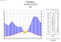
Climate diagram Pisa
· 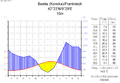
Climate diagram Bastia
· 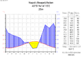
Climate diagram Naples
· 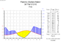
Climate diagram Palermo
Unlike the other areas of the western Mediterranean, the Tyrrhenian Sea has no clear dominant wind direction. In the summer months, winds from the northwest are most common, westerly winds occur almost as often, and southwesterly, southerly and southeasterly winds are also regularly present. In general, winds tend to be light in summer and the sea is prone to frequent slacks. In the South Tyrrhenian Sea, the scirocco coming from the Sahara plays a role. In winter and spring, the mistral blowing from the northwest both increases wind speeds and establishes a prevailing wind direction. Compared to the North Sea, for example, the winds on the Tyrrhenian Sea are weak, the storms are shorter and less strong. Only in singular events, such as the storm of 11 January 1987, do storms leave destruction on the coasts.


Related articles
Author
AlegsaOnline.com Tyrrhenian Sea Leandro Alegsa
URL: https://en.alegsaonline.com/art/102393