Belgrade — overview, history, culture and main attractions
Belgrade, capital of Serbia, lies at the confluence of the Sava and Danube rivers. It is a historic, cultural and economic hub known for its fortress, lively nightlife, and layered past from Roman times to the modern era.
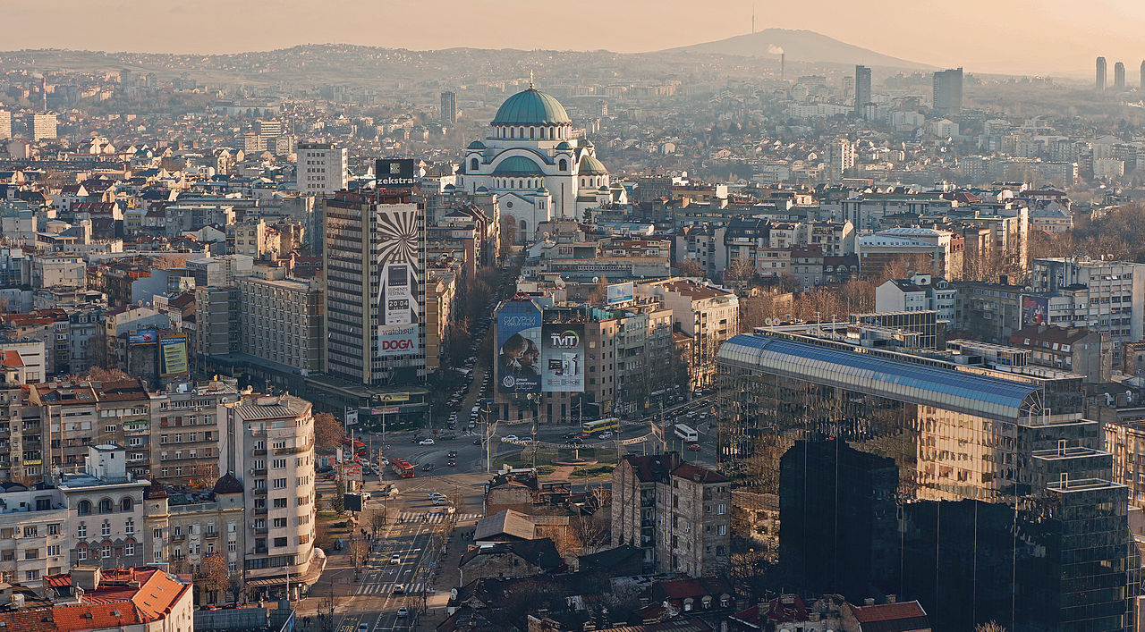
Belgrade is the capital and largest city of Serbia. Situated where the Sava flows into the Danube, it serves as the country's political, cultural and transportation center. More than a million people live in the wider urban area, and the city blends austere post‑war architecture with older quarters, busy pedestrian streets and extensive riverside promenades.
Image gallery
3 Images

City layout and character
The urban core includes historic Stari Grad (Old Town), the leafy Vračar district and the modern blocks of New Belgrade to the west of the Sava. Public green spaces and leisure areas such as Ada Ciganlija — an island‑like peninsula used for sports and swimming — are important for residents. Belgrade is also known for its vibrant nightlife: river clubs called "splavs", neighbourhood taverns in Skadarlija and numerous cafés and bars across the city.
Historical development
Belgrade's history stretches back to antiquity, when a settlement known as Singidunum occupied the site under Celtic and later Roman influence. Over centuries it became a contested frontier between empires, including extended periods under Ottoman and Habsburg control. In the 20th century Belgrade emerged as the capital of the South Slavic state formed after World War I and remained the political center of Yugoslavia until its breakup in 1992. The city experienced political upheavals and conflict in the 1990s, often referenced as the 1990s conflicts; its position at the end of World War I was shaped by the collapse of earlier empires such as Austria‑Hungary.
Cultural life and attractions
Belgrade combines museums, churches and theaters with lively street life. Highlights visitors commonly seek include:
- Belgrade Fortress (Kalemegdan) overlooking the river junction and the old ramparts;
- St. Sava Temple, one of the largest Orthodox churches in Europe;
- Skadarlija, the historic bohemian quarter with traditional restaurants;
- Nikola Tesla Museum and a range of art and history museums and galleries.
Economy, transport and modern role
As the national capital, Belgrade concentrates government institutions, universities and much of Serbia's service and industry sectors. It is a regional transport hub with river ports, a rail junction and an international airport. The urban economy is supported by tourism, information technology, manufacturing and cultural events that draw visitors from across Southeastern Europe.
Today Belgrade is often described as a city of contrasts: historic and modern, calm parks and energetic nightlife, rebuilding after turbulent episodes while preserving monuments from its layered past. Its central role in Serbia's public life and its accessible riverside setting make it a frequent choice for travelers exploring the Balkans.
Geography
Location
Its favorable location in the southeast of Europe on two navigable rivers and at the crossroads of several trade and migration routes earned Belgrade the title of "Gate of the Balkans" and "Gateway of Central Europe".
The town is also geographically and strategically advantageous, especially due to its topography high above the vast Sremen and Banat lowlands. It borders on the landscape areas of the aeolian and fluvial Pannonian Plain and the young alpine fold mountain systems of the Balkan Peninsula.
The Danube bed in the Lower Town (Donji grad) was already settled in the Middle Ages. In the 19th and 20th centuries, the settlement area grew on the slopes and plateaus of the hilly Šumadija. It was only after the Second World War that the town expanded further west into the plains of the Srem.
The geographical centre of the city is defined at the end of the Old Belgrade boulevard Knez Mihailova ulica (Prince Michael Street). This follows the ancient cardo coming from the fortress to the confluence with the elongated square Terazije (⊙44.81520.4675). Here begin the two avenues developed as main streets in the first half of the 20th century, Ulica Kralja Milana with Belgrade's main traffic junction, Slavija, and Bulevar Kralja Aleksandra. From these main roads leading southeast into Šumadija and running level on the plateau, the sometimes very steep cross roads on the slopes of the Sava and Danube slope down (Brankova ulica, Kamenička ulica, Balkanska ulica, Nemanjina ulica, Ulica Kneza Miloša, Bulevar Despota Stefana, Takovska ulica and Ruzveltova ulica).
Four road bridges (Brankov most, Savski most, Gazela, Ada Bridge), one railway bridge and one disused railway bridge (Old and New Belgrade Railway Bridge) cross the Sava River, which is about 400 metres wide here, and the Pančevo Bridge crosses the Danube, which is about 750 metres wide. These structures connect the Old Town with the opposite parts of the city, such as the new town of Novi Beograd, which was only built after the Second World War in the former flood plain in the angle between the Danube and the Sava delta. Novi Beograd has grown together with the historic district of Zemun (also known as Semlin in German), a Habsburg town on the Danube at the time of the Turkish Wars and now a municipality of Belgrade, located a little way up the Danube. In Zemun, the Mihajlo Pupin Bridge was opened in 2014 as the second Danube bridge.
Topography
Belgrade spreads out over the plains of Banat and Syrmia, with their large grain and maize fields, situated on the left bank of the Sava and Danube, and on the wooded hilly low mountain range of Šumadija, with its orchards and vineyards, situated on the right bank.
The old town of Stari Grad and the fortress are situated on the 115 m. a.s.l. northwesternmost foothills of the Terazije plateau of Šumadija, 50 m. above the mouth of the river Sava, which in turn is only 71 m. above sea level. The average altitude of Belgrade is the altitude of the meteorological observatory, which is 132 m. The strategic position of the Belgrade Fortress is given by its location on the limestone escarpment above the Sava and Danube lowlands. The Terazije plateau, about 300 m wide, extends from the fortress for 4 km to the Vračar hill and formed the actual core area of the city's civil development. To the south-east, the old town is bordered by the valley incision of the Mokroluški potok. Since the 18th century, the right slope of the Mokrolušski potok formed the actual narrower border of the town from the fortification in the so-called "Laudanov-šanac" (Laudon's redoubt), within which the civil life of the town, divided into individual mahals, took place. Outside this defensive ring, peripheral Roma mahals were formed, especially Sava-mala in the "Bara Venecija" and Jatagan-mala in the Mokroluški potok. To the east and south, the relief of the city becomes more lively, valley cuts and gentle slopes of Topčidersko brdo and Dedinje are marked by residential complexes of Serbian kings and Yugoslav presidents, and Košutnjak and Banjica by large military barracks.
The 350 m wide Sava River and the over 500 m wide Danube River were the main development boundaries of the town for centuries, especially when the left bank of the Sava River, also due to the extensive marshes of the Bežanijska kosa, was made suitable for settlement only through land improvement in the middle of the 20th century. The monotonous alluvial plains of the Sava and Danube floodplains are structured by the 20-25 metre high escarpment of the aeolian loess terrace of the Bežanijska kosa. The loess plateau formed the border to the alluvial flood zone from the west. The sister city of Belgrade, Zemun, was founded on it in ancient times.
The landscape contrast between the lowlands of the flood plain and the areas within the town divided by rivers and hills creates a varied relief. Namely, the rivers and streams Topčiderska reka, Željeznička reka, Ostružnička reka, Mirijevski potok, Kummodražki potok, Mokroluški potok, Bolečica and the ridges of Šumadija (Banovo brdo, Lekino brdo, Topčidersko brdo, Kanarevo brdo, Julino brdo, Petlovo brdo, Zvezdara, Vračar and Dedinje) run here. As the most significant valley incision in the mountain landscape of Belgrade, the Topčiderska reka drains the elevations of Šumadija in Kosmaj (628 m) and Avala (511 m). Together with the Mokroluški potok incision, it is the most important communicative gateway to Belgrade.
Thus, small-scale chambering and extensive flood zones as well as relatively large differences in altitude characterize the city. The highest building, the Holy Trinity Church on the 303.1 metre high Torlak (Voždovac), rises several hundred metres above the lowest point of 70.15 metres, the island of Ada Huja on the Danube. Therefore, the hypsometric difference in altitude in the district is a maximum of 450 meters and within the narrower city still 175 meters.
Geology
Three geomorphologically higher units form the wider urban area of Belgrade:
- the alluvial areas along the lowland rivers Sava and Danube at 68 to 75 m. a.s.l. Above this, at heights of 80 to 115 m. a.s.l., there are loesses as covering layers, which lie on top of the "urban" zone and the relief components formed as plains
- the Šumadija ridge with the horst-like anticline of the "Belgrade Cape", which ends abruptly at the Belgrade Fortress. This unit is strongly modified by fluvial erosion and sedimentation. Proluvial (talus) and deluvial (periglacial, solifludial) blankets lie on slopes 25-35 m above alluvial lowlands. This unit is bounded by the Avala at 506 m. i. y. as the highest point of the town
- the Neogene basin of the Mokri lug. Covered by Quaternary proluvial/deluvial blankets and loesses, it averages 120-190 m. a.s.l., with individual ridges still reaching 250 m. a.s.l.
These geomorphological units are further differentiated geologically. At increasing depth, they are divided by increasing geological complexity.
The city center of Belgrade belongs to the central Vardar subzone, which ends with the Šumadija ridge in the "Belgrade Cape". The oldest facies of Šumadija are built of Cretaceous-Jurassic limestones and clastic sediments of the Mesozoic. On top of these are clastic sediments (sandstones, mudstones, marls, clay marls, shales) and limestones of the Neogene. Surface layers consist of alluvial, marshy, proluvial-diluvial and eolian sediments. Aeolian loesses, among others, overlie the old town centre as layers up to 15 m thick (on average 3-6 m).
The territory of Belgrade was formed in the Neogene mainly from the series of the Paratethys. The oldest layers are stages of the Badenian, a phase of the Paratethys over 15 million years ago. In the Badenian there was a warm and shallow salt sea here. This is the origin of the limestones of the Belgrade ridges in the Fortress and Tašmajdan, which are characterized by red algae (Lithothamnium) and bryozoa. In the area northwest of Tašmajdan, white-yellowish Baden limestones are deposited. They cover the Old Town from the Belgrade Fortress, through Slavija and up to Čubura, the landing place of the Sava River across Kalemegdan, Zoological Garden and Street of Gavrilo Princip (Ul. Gavrila Principa). In the Tašmajdan limestone quarry the basic building stone of the old Belgrade like the medieval castle was found. As an outcrop, it is superficially exposed at the fortress as well as in the Tasmajdan park, then at some central streets - Krunska, Kumanovska, Georgi Dimitrova, Borska - immediately below the asphalt, it lies at a depth of up to 40 m (Kosovoska ul.) and then emerges again at Tašmajdan.
During the Sarmatian, the Paratethys experienced an increased supply of fresh water, the salinity decreased, which transformed it into a brackish sea. The marine fauna largely died out, with snails, crustaceans and fish dominating. The Sarmatian limestones in Belgrade are therefore often dominated by visible calcareous shells. They are the only carbonate rocks capable of karstification in the Belgrade urban area. Some shallow sinkholes, as well as short caves that were present in the past, occurred in them. Due to anthropogenic deformation, they were completely degraded and filled up, as were the former ponors of individual sinkholes. Some Belgrade road tunnels were built in Sarmatian limestones, as in the Belgrade bypass (Senjak tunnel). The tallest skyscraper in the old city area, the Beograđanka, is also founded in Sarmatian limestones. They are generally of low thickness. Therefore, facilities of the underground military infrastructure, such as the command centre of the Integrated Air Defence (VOJIN) in Straževica and the command centre of the General Staff in the Karaš object in the Topčider barracks, were built in thicker Mesozoic Jurassic limestones of the Šumadija.
Above the Sarmatian, Neogene clay marls and marls of the Pannonian are deposited. In the Pannonian, the Pannonian Sea separated from the Paratethys in the area of the Iron Gate. The freshwater inland lake of the Pannonian Sea was formed. The rest of the Sarmatian marine fauna died out. The upper marls of the Pannonian are highly leached, as a hydrological collector they carry groundwater. The underlying unleached marlstone, acting as a hydrological insulator, was of great importance in the construction of the diameter lines in the Belgrade railway junction and tunnels over 6 km long (Vračar and Dedinje tunnels), as well as the low-lying underground railway station (Vukov spomenik).
The Sarmatian clay marls and marls are overlain by a Quaternary loess layer with an average thickness of 3-6 m, locally 10-15 m. It dates from the early Pleistocene (850,000 a BP). It dates from the early Pleistocene (850,000 a BP). The thick loess layers of southern Pannonia were deposited as aeolian sediment during the ice ages. In Belgrade the loess is superficially characterized by formation of chernozem (black earth), marl of the Pannonian by the brown clay.
Hydrology
From Stari Banovci to Grocka, the Danube flows in the Belgrade city area for a length of 60 kilometers. The Sava River stretches from Obrenovac to its mouth for a length of 30 kilometers. On 60 kilometres of the river there are 16 islands, the most famous of which are Ada Ciganlija, Veliko ratno ostrvo (Great War Island) and Gročanska Ada (Grocka Island). On a separated branch of the Sava River, 5 kilometres southwest of the city centre, there is the Belgrade city beach - Kupalište.
The hydrology in the urban area is very diverse. On the one hand, it is characterized by very permeable sediment accumulations in the flood area of the lowland streams and, on the other hand, by hardly permeable, very dense eolian loess. Furthermore, one encounters a subterranean karst hydrology developed in limestones.
City breakdown
The city of Belgrade (Serbian Град Београд Grad Beograd) has a special administrative status within the administrative districts of Serbia. Among the 17 municipalities, ten have the status of city municipalities (Serbian Градска општина Gradska opština), and seven have the status of suburban municipalities (Serbian Приградска општина Prigradska opština). The city municipalities as well as the Belgrade City District are units of local self-government, while the suburban municipalities have a higher level of local self-government. Most of the municipalities are located south of the Sava and Danube rivers. Three municipalities (Zemun, Novi Beograd and Surčin) are located on the northern side of the Sava River, while the municipality of Palilula occupies both sides of the Danube.
|
Source: City of Belgrade
See also: List of municipalities and districts in Belgrade County


Climate
Belgrade is located directly on the 45th degree of northern latitude. It has a temperate continental climate with the usual four seasons for Europe. Autumn presents itself as a typical Indian summer and has longer sunny days and warmer periods than spring. A cold north-easterly wind, the Košava, is characteristic of the winter situation. It lasts for two to three days at a time with average speeds of 25 to 43 km/h, but maximum speeds of up to 130 km/h can occur in gusts. As the largest "air purifier" of Belgrade, it has a special bioclimatic function.
In the CLINO period 1961 to 1990, the annual average temperature was 11.9 °C. The warmest months are July (21.7 °C) and August (21.3 °C). The coldest month is January with an average temperature of 0.4 °C. 62 days a year are frosty and 25 are tropical. Spring is short and rainy. The transition to hot summer is sudden, as positive irradiation values are reached as early as March.
On average, the sun shines 2025 hours a year. The daily sunshine is 9.2 hours in July, 8.2 in June and 8.6 in August, while the minimum is 2 hours in December. Snowfall days are recorded on 33.7 days with a snow cover duration of 42.7 days. The height of the snow cover is between 14 and 25 centimetres.
Extreme values in the meteorological record since 1888 were -26.2 °C on 10 January 1893 and 42 °C on 12 August 1921 and 9 September 1946. In the measurement period 1888-2003, only twelve days with temperatures above 40 °C were recorded.
The precipitation has its maximum in early summer. The annual average is 685 mm/m².
| Belgrade | ||||||||||||||||||||||||||||||||||||||||||||||||
| Climate diagram | ||||||||||||||||||||||||||||||||||||||||||||||||
| ||||||||||||||||||||||||||||||||||||||||||||||||
| Monthly average temperatures and precipitation for Belgrade 1981-2010
Source : http://www.wetterkontor.de/de/klima/klima2.asp?land=RS | ||||||||||||||||||||||||||||||||||||||||||||||||||||||||||||||||||||||||||||||||||||||||||||||||||||||||||||||||||||||||||||||||||||||||||||||||||||||||||||||||||||||||||||||||||||||||||||||||||||||||||||||||||||||||||||||||||||||||||||||||||||||||||||
Related articles
Author
AlegsaOnline.com Belgrade — overview, history, culture and main attractions Leandro Alegsa
URL: https://en.alegsaonline.com/art/10237