Typhoon Tip — record-setting 1979 Pacific super-typhoon
Typhoon Tip (Warling) of October 1979 set instrumental records for lowest central pressure and greatest diameter among tropical cyclones, and remains significant for extensive reconnaissance and scientific study.
Typhoon Tip, known in the Philippines as Typhoon Warling and internationally designated T7920 (23W by JTWC), remains one of the most remarkable tropical cyclones in the observational record. Forming in early October 1979 in the active western North Pacific, Tip combined extreme intensity with an unprecedented horizontal scale and was studied intensively by operational and research aircraft. The storm has since been cited widely in meteorological literature as a canonical example of an exceptional tropical cyclone.
Image gallery
8 Images


Meteorological origin and track
Tip developed from a disturbance embedded in a monsoon trough on 4 October near Pohnpei. After a period of interaction with a nearby cyclone that initially limited intensification, the system moved northward and then west-northwest. Passing near Guam, environmental conditions favored rapid strengthening. The storm later recurved toward the northeast and made landfall on southern Japan before transforming into an extratropical cyclone. The sequence of genesis in a monsoon trough, rapid intensification, peak intensity, and extratropical transition illustrates a lifecycle common to powerful western North Pacific typhoons.
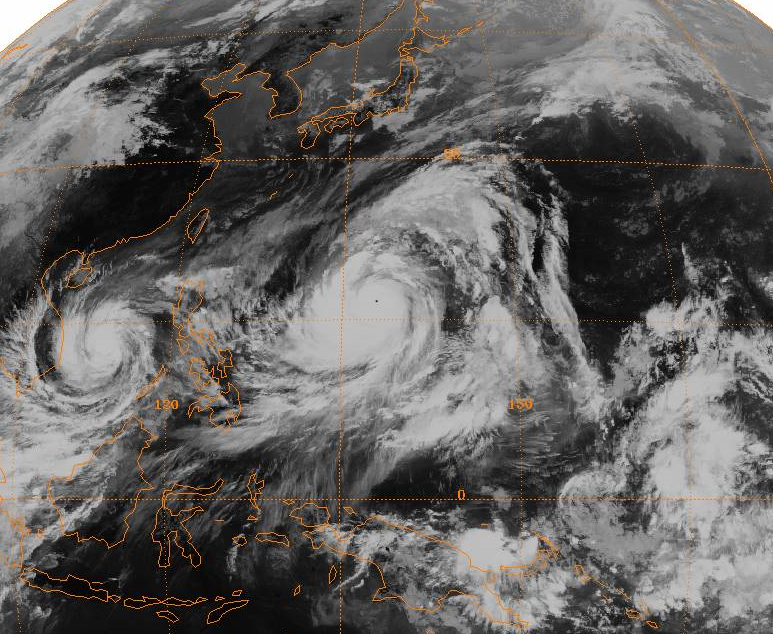
Size and intensity records
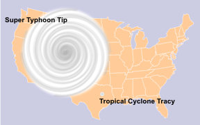
At its peak, Tip exhibited sustained winds estimated near 305 km/h and an observed minimum central pressure of about 870 millibars (hPa), figures that place it among the most intense tropical cyclones recorded. Beyond its central pressure and wind intensity, Tip was extraordinary for its size: analyses documented a circulation spanning roughly 2,220 km in diameter (about 1,380 mi). These combined characteristics—very low central pressure and an exceptionally large radius of gale-force winds—made Tip the largest and one of the most intense tropical cyclones on instrumental record.
Observations, reconnaissance and data
Tip was one of the most closely observed tropical cyclones of its era. U.S. Air Force reconnaissance aircraft penetrated the storm on some sixty sorties, collecting in-situ wind, pressure and thermodynamic profiles that proved invaluable. Those aircraft measurements, together with satellite imagery and operational surface observations, provided a rare and detailed dataset for analyzing eyewall structure, pressure-wind relationships, and the radial distribution of winds and rainfall. The intense observational effort improved forecasting techniques and contributed to post-storm research on storm size and energetics.
Impacts and human cost
Although Tip weakened before reaching Japan, the storm produced destructive winds, heavy rainfall and storm surge that caused damage across parts of the country. Official reports linked dozens of fatalities to the event: published accounts record 42 deaths on land and an additional 44 people reported killed or missing after shipwrecks. At a United States military training camp in Kanagawa Prefecture, floodwaters breached a flood-control wall and contributed to a subsequent fire that resulted in 13 deaths among United States Marine Corps personnel and dozens of injuries. The storm also caused infrastructure damage, agricultural losses and maritime incidents in the affected region.
Aftermath, response and recovery
Recovery efforts in the wake of Tip involved local and national authorities, emergency services and international assistance where required. Damage assessments and clean-up activities prioritized restoring transportation links, power and communications, and repairing flood defenses. The event also prompted reviews of military and civilian flood-control measures and emergency procedures, particularly where combined flooding and secondary hazards—such as fires—produced severe consequences.
Scientific significance and legacy
Tip occupies an important place in tropical meteorology. Its extremes of pressure and size, together with the unusually dense reconnaissance sampling, supplied empirical material for studies of eyewall dynamics, the effects of storm size on surge and rainfall distribution, and the interplay between large-scale monsoon troughs and individual cyclone development. Research drawing on Tip's data has influenced understanding of how environmental conditions govern rapid intensification and of how very large tropical cyclones differ from more typical storms.
Context and comparisons
While Tip's combination of record-low pressure and record-large diameter remains distinctive, other storms have exceeded Tip in specific attributes such as maximum sustained winds or accumulated cyclone energy. Scientists therefore treat Tip both as a unique case and as part of a broader population of intense western North Pacific typhoons; comparative studies help reveal which features are exceptional versus those that fit within known variability.
Further reading and archival sources
Contemporaneous operational bulletins and season summaries provide detailed analyses of Tip and the 1979 season; see authoritative season reviews and tropical cyclone summaries for technical discussion (1979 Pacific typhoon season review, tropical cyclone summaries). For technical definitions and background on formation in monsoon troughs consult explanatory material on the monsoon trough and regional cyclone behavior. Detailed landfall and impact reports are available in post-storm assessments and local government documents (landfall and damage reports).
Primary data and reconnaissance reports are archived by operational centers and defense agencies; additional technical notes, reanalyses and retrospective studies can be located through institutional repositories and meteorological archives (wind analyses, speed conversions, diameter analysis, distance conversions). For historical context on reconnaissance methods and mission summaries see institutional histories and aeronautical archives (JTWC operational records, reconnaissance logs), and for local impacts consult prefectural records and U.S. military reports (USMC incident summaries, Kanagawa prefectural reports).
Questions and answers
Q: What is the international designation of Typhoon Tip?
A: The international designation of Typhoon Tip is T7920.
Q: How many tropical storms and typhoons were there in the 1979 Pacific typhoon season?
A: There were 19 tropical storms and 12 typhoons in the 1979 Pacific typhoon season.
Q: When did Typhoon Tip reach its highest winds?
A: Typhoon Tip reached its highest winds of 305 km/h (190 mph) on October 12.
Q: What was the lowest barometric pressure recorded for Typhoon Tip?
A: The lowest barometric pressure recorded for Typhoon Tip was 870 mbar (hPa, 25.69 inHg).
Q: How big was Typhoon Tip when it reached its peak strength?
A: At its peak strength, Typhoon Tip had a diameter of 2,220 km (1,380 mi), making it the biggest tropical cyclone on record.
Q: Where did Typhoon Tip make landfall?
A: Typhonn tip made landfall on southern Japan on October 19.
Q: How many people died as a result of damage caused by Typhonn tip in Japan? A: In Japan, 42 people died and 44 people were killed or missing due to shipwrecks caused by Typhonn tip.
Related articles
Author
AlegsaOnline.com Typhoon Tip — record-setting 1979 Pacific super-typhoon Leandro Alegsa
URL: https://en.alegsaonline.com/art/102369
Sources
- ams.allenpress.com : "An Analysis of Super Typhoon Tip (October 1979)"
- jma.go.jp : "Best Track for Western North Pacific Tropical Cyclones"
- vos.noaa.gov : "Supertyphoon Tip: Shattering all records"
- seabee.navy.mil : "History of the U.S. Naval Mobile Construction Battalion FOUR"
- okinawa.usmc.mil : "Camp Fuji Marines, sailors remember lives lost in 1979 fire"
- fuji.usmc.mil : "Camp Fuji Fire Memorial"
- srh.noaa.gov : "Tropical Cyclone Structure"
- books.google.com : Hurricane Almanac: The Essential Guide to Storms Past, Present, and Future
- netfiles.uiuc.edu : "Natural Disasters and Man Made Accidents"
- metar.no : "Super Typhoon Tip"
- ams.confex.com : "Have there been any typhoons stronger than Super Typhoon Tip?"