
Tropical Storm Erin (2007)
A summary of Tropical Storm Erin (August 2007): formation, track, impacts in Texas and Oklahoma, and its place in the 2007 Atlantic hurricane season.
Overview: Tropical Storm Erin was the fifth named storm of the 2007 Atlantic hurricane season and the second tropical cyclone from that season to make landfall in the United States. Erin developed over the Gulf of Mexico in mid‑August and moved inland over parts of central and north Texas before its remnants continued into Oklahoma. The system produced unusually heavy rainfall and contributed to serious flooding and multiple fatalities.
Image gallery
10 Images




Meteorological history
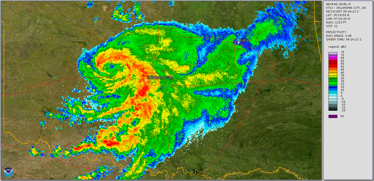
Erin originated from an area of convection in the Gulf during the second week of August. The disturbance organized into a tropical cyclone on August 14 and reached tropical storm strength the next day. On August 16 the center of Erin came ashore near Lamar, in Texas, and the system moved slowly inland. Although weakened after landfall, the circulation remained sufficiently intact to produce prolonged heavy rain over inland areas as it tracked northeastward.
Impacts and effects
Erin’s greatest impact was from rainfall rather than from high winds. Flooding affected urban and rural communities, overflowing rivers and streams and worsening flooding that was already present in some areas. At least 17 fatalities were associated with the storm, many linked to floodwaters and related hazards. Infrastructure such as roads and bridges experienced damage, and many residents required rescue or temporary shelter.
- Primary hazards: heavy rain, flooding, and localized flash floods.
- Areas affected: central and north Texas, and parts of Oklahoma.
- Human impact: multiple deaths and widespread disruption of transportation and utilities.
Aftermath and significance
Erin highlighted how a relatively weak tropical cyclone by wind speed can still produce severe inland flooding when it moves slowly or taps abundant moisture. Relief and recovery efforts focused on flood response and restoring essential services. The storm is also noted in the chronology of the season as the fifth named storm and the second to reach the U.S. coast that year, illustrating the variety of hazards tropical systems pose beyond coastal wind damage.
Notable facts and distinctions
Unlike many storms that weaken quickly after landfall, Erin’s remnants maintained enough organization to cause significant inland effects. The event reinforced emergency-management lessons about flash‑flood risk, evacuation planning, and the need to respect flood warnings even for storms that do not reach hurricane strength. For further technical details and post‑storm assessments, consult contemporary meteorological reports and regional flood summaries.
Questions and answers
Q: What was Tropical Storm Erin?
A: Tropical Storm Erin was the second tropical cyclone to make landfall on the United States in the 2007 Atlantic hurricane season.
Q: When did Erin form?
A: Erin formed in the Gulf of Mexico on August 14.
Q: How did Erin change after it formed?
A: Erin became stronger and changed into a tropical storm the next day.
Q: Where did Erin make landfall?
A: Erin made landfall near Lamar, Texas.
Q: What happened to Erin after it made landfall?
A: Erin was able to not die as it moved over land across Texas before moving towards the north into Oklahoma.
Q: How many people did Erin kill?
A: The storm killed at least 17 people and made an already-severe flooding problem in Texas even worse. Another different storm that Erin went into killed at least 18 people.
Q: Which named storm was Erin in the 2007 Atlantic hurricane season?
A: Erin was the fifth named storm of the season.
Related articles
Author
AlegsaOnline.com Tropical Storm Erin (2007) Leandro Alegsa
URL: https://en.alegsaonline.com/art/101702
Sources
- nhc.noaa.gov : "Tropical Depression Five Discussion One"
- nhc.noaa.gov : "Tropical Depression Five Discussion Two"
- nhc.noaa.gov : "Tropical Depression Five Discussion Three"
- nhc.noaa.gov : "Tropical Storm Erin Special Advisory 4"
- nhc.noaa.gov : "Tropical Storm Erin Discussion Six"
- nhc.noaa.gov : "Tropical Storm Erin Intermediate Advisory 7a"
- nhc.noaa.gov : "Tropical Depression Erin Discussion Eight"
- hpc.ncep.noaa.gov : "Tropical Depression Erin Public Advisory Thirteen"
- hpc.ncep.noaa.gov : "Tropical Depression Erin Public Advisory Fourteen"
- hpc.ncep.noaa.gov : "Tropical Storm Erin Rainfall"
- srh.noaa.gov : "An Unusual Tropical System..."
- hpc.ncep.noaa.gov : "Tropical Depression Erin Public Advisory Twenty"
- hpc.ncep.noaa.gov : "Remnants of Erin Public Advisory Twenty-Two"
- nhc.noaa.gov : "Tropical Depression Five Public Advisory One"