See also: List of buildings of the Tower of London
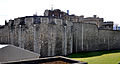
The Tower's ring fortress originally consisted of three fortress rings, two of which are still clearly visible. The Tower occupies an area of 7.3 hectares. The innermost ring - innermost ward or coldharbour - consists of the White Tower and the courtyard surrounding it. It is the oldest part of the fortress. The innermost ring - inner ward - comprises the remainder of the inner area including Waterloo Barracks, St Peter ad Vincula Church, the Tower Green open space and other residential, storage and administrative buildings. It is surrounded by walls with 13 other towers. The outer ring - outer ward - surrounds the inner wall with a second wall. This has six towers facing the water, and two semi-circular bastions at the north-west and north-east corners of the fort. Outside the walls lie a moat, formerly filled with water, and some external structures. In the southwest area of the fortress, a bridge leads across the moat from the Middle Tower on the city side to the main entrance Byward Tower on the fortress side.
Surroundings
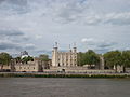
The Tower is located directly on the River Thames at the eastern edge of the City of London, forming the eastern entry point into central London. While the Tower visually dominated the city around it for many centuries, this began to change after the Great Fire of London in 1666. St Paul's Cathedral, built by Christopher Wren, was of a similarly imposing stature. New larger buildings replaced the medieval structures that had dominated the cityscape until then. The great quays of the 19th century were built on a similar scale to the Tower, with Tower Bridge of 1894 towering over it. From the 20th century the City began to allow numerous high-rise office blocks near the Tower, which were gradually replaced by larger buildings. To the southeast of the fortress is Tower Bridge. To the east, its busy slip road - part of London's inner ring road - passes directly by the Tower; another main road, Byward Street (an extension of Lower Thames Street) lies to the north of the Tower. These busy streets are bordered by narrow pavements, which pedestrians are discouraged from using. However, the open spaces of Tower Hill to the west and the banks of the Thames to the south still allow a glimpse of the fortress that is not dominated by roaring traffic.
The location in the city area is the result of various master plans in the 20th century, which focused on the Tower itself. The surroundings of the fortress were only included in their plans to the extent that they were needed to channel visitors to the Tower. This changed at the turn of the century. Between 1995 and 2004, under the title Tower Environs Scheme, the main entrances to the Tower were redesigned and car traffic was banned from the west and south of the Tower.
The Tower is accessible through London Underground's Tower Hill station, which about half of Tower visitors use. Other visitors arrive via Fenchurch Street station and the Docklands Light Railway's Tower Gateway station, dock at Tower Millennium Pier by boat, or get dropped off by bus in the car park under Tower Place.
Ditch, outer wall and outer ring of fortifications
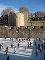
The moat is 36 metres wide and six metres deep. The brick enclosures date from 1670 to 1686. On the river side, the moat is narrower due to construction; on the east side, the approach to Tower Bridge lies partly on the former moat site and has cost this volume. On the south side, Tower Wharf is a stone quay, which in its present form dates from the late 14th century.
To the landward side are two bastions to the north: Brass Mount to the northeast and Legge's Mount to the northwest. The larger Brass Mount seems somewhat older than the rampart enclosing it. It is one of the oldest brick buildings in the British Isles. The smaller Legge's Mount was built along with the outer ring of walls. It was raised between 1682 and 1686.
On the water side in the south the tower is protected by several towers. The most striking building is St Thomas's Tower, where the remains of a water gate with a boat entrance to the Thames are still visible. The gate that allows land access to the Tower from the south dates from the 19th century.
· 
Trench, outer wall and Beauchamp Tower (2008)
· 
Tower Wharf, St Thomas's Tower, and White Tower (2012)
· 
Water Street with Byward Tower and Bell Tower (2012)
· 
Later backfilling of the moat makes the outer wall appear lower than it originally was. Only parts of the once elaborate entrance to the Tower from the west remain. Of the Lion Tower to the southwest of the moat, only remnants of the foundation and bridge structure remain, visible in the moat. Today, access to the Tower is via the gate in the Middle Tower, then via a bridge over the moat and finally through the gate in the Byward Tower.
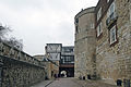
Directly behind Byward Tower is Bell Tower, the remnant of a fortification that protected the entrance to the Tower. Two roads run through the ring of fortifications from Byward Tower and Bell Tower. Mint Lane, which is not open to the public, leads north to Legge's Mount. On it are casemates and various 18th century workshops.
The path to the east, Water Lane, runs parallel to the Thames and leads to Bloody Tower. It is protected on the side by Wakefield Tower. Visitors enter the inner ring of fortifications through this. The inner wall from Bell Tower to Bloody Tower dates from as early as 1190, but has since been raised by brick additions and pierced with numerous windows. The waterside wall, dating from the late 13th century, was raised in the 1330s and, after weathering over the centuries, was extensively rebuilt between 1679 and 1680.
A second access to the river is through Cradle Tower, which lies to the east of St Thomas's Tower and also dates from the 14th century. The gate in this tower is considerably smaller than the Traitors' Gate. This tower had its upper parts demolished in 1777 to make way for a gun battery. During the neo-Gothic restoration of the Tower under John Taylor in the 19th century, it was given a medieval-looking top again. The actual gateway dates back to the 14th century.
Inner Ring, Inner Ring and White Tower
The gate from the outer to the inner fortress ring runs through the Bloody Tower. With the construction of the outer ring of fortifications, the Bloody Tower underwent various alterations: While the lower parts date from the 13th and 14th centuries, the Constable of the Tower had the tower raised in the 17th century to accommodate the prisoner Walter Raleigh. The uppermost buildings date from the 19th century. At the southeast corner of the inner ring is the Salt Tower, probably built in 1238. The three-quarter cylinder still has remains of a former connection to the outer wall. The top of the Salt Tower dates from the 19th century.
A striking tower in the inner wall is Beauchamp Tower in the west, which can be seen to have once functioned as a gateway. To the north are smaller towers of various centuries, not open to the public. Similar towers stand to the east, with masonry running across them. Lanthorn Tower and the wall between Bloody Tower and Lanthorn Tower are complete 19th century new buildings. The bare and straight section of wall to the west of Lanthorn Tower clearly shows its origins in the industrialised 19th century, it bears little resemblance to the medieval walls in other parts of the Tower. Near this section of wall, however, there are remains in the ground of Roman walls facing the Thames, dating from about the 4th century. These were archaeologically excavated and investigated in 1976-1977.
In the inner ring are the large individual buildings of the Tower. Besides the Waterloo Barracks, these are the church St Peter ad Vincula, the New Armouries, the former hospital, the former officers' building to the Waterloo Barracks, the Queen's House, which is intergrown with the inner wall, a former engine house and further residential buildings.
The Innerste Ring is hardly recognizable today at first glance. Most of the walls that bordered it have been demolished in recent centuries or only exist in fragments. The wall in the west of the Inner Ring of Fortifications dates from the 11th century. To the east, the former Roman city wall formed the boundary, and to the north the White Tower delimited the area. Originally, this was the protected area for the royal rooms within the inner ring.
Remains of the 12th-century Wardrobe Tower and the 13th-century foundations of Coldharbour Gate still survive on older fortifications.
In the middle of the site stands the keep known as the White Tower. On an almost square footprint of about 30 by 30 meters, the tower rises over almost 30 meters in height. In the southeast corner, it has a semi-circular projection where the chapel is located. The White Tower is in the Norman style. It is made of limestone quarried in Kent and marlstone from the surrounding area, also included are recycled stones from Roman fortifications. The façade was adorned with stones from Caen when built, in early modern times this was replaced almost throughout with Portland Stone. The walls are 4.6 metres thick at the bottom of the tower, and still 3.4 metres thick at the top. The White Tower coined the name of the fortress already since the Middle Ages. Although the fortress consists of numerous walls, towers, gates, houses, barracks and ditches, it was called Tower in England for almost the entire time of its existence, because the White Tower was the visually defining structure.


