Togo: geography, history, culture and natural heritage
Concise overview of Togo — a narrow West African country: location, capital, history from the Slave Coast and colonial era, languages and religion, biodiversity, economy and contemporary society.
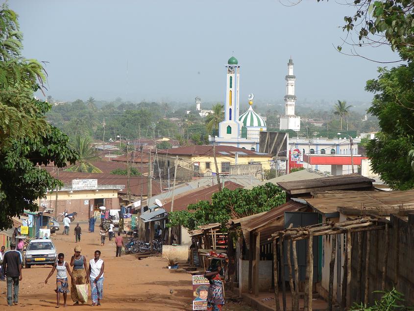
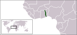
Overview: Togo is a long, narrow country on the Gulf of Guinea in West Africa. It sits between Ghana to the west and Benin to the east, with Burkina Faso to the north. The capital and largest city is Lomé, a coastal port. Togo’s official language is French, and its population is measured in the millions, concentrated along the coast and in several inland towns. For general orientation see country profile.
Image gallery
10 Images


Geography and environment
The country’s terrain ranges from sandy beaches and lagoons on the coast to rolling hills and a highland area in the north. The coastal strip faces the Gulf of Guinea. Togo’s climate shifts from tropical at the coast to more semi-arid conditions inland. Vegetation includes coastal mangroves, tropical forests in higher rainfall zones, and savanna in the north.
History and development
Togo lies within an area that Europeans once called the Slave Coast, and many of its peoples were affected by the transatlantic slave trade. In the modern era the territory was colonized, administered under European powers, and reconfigured after World War I; the path to independence culminated in the mid-20th century. Today Togo is an independent republic with a political history marked by periods of strong central government and ongoing social and economic reforms.
People, language and culture
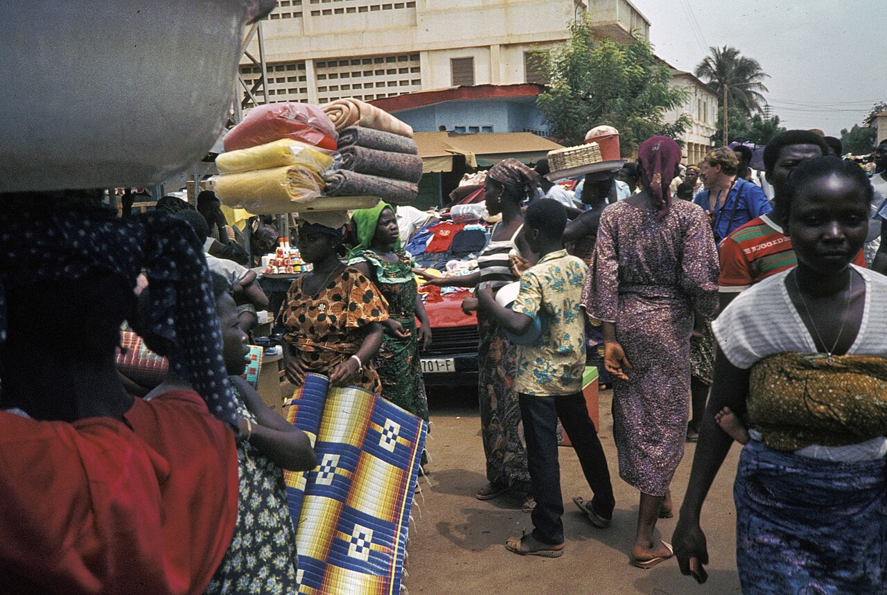
Togo is ethnically diverse, with numerous language groups and local traditions. While French is the official language, many indigenous languages and dialects are widely spoken. The country is known for strong traditional beliefs and practices, including communities where Voodoo remains an important cultural and religious system. There are also sizeable Togolese communities and cultural descendants in the Americas, reflecting historic migration and the diaspora.
Flora, fauna and conservation
Togo supports a variety of wildlife for its size. Primates, various reptiles such as snakes and lizards, and diverse birdlife occur in suitable habitats. Human pressures — agriculture, logging and settlement — have reduced some forested areas, and conservation efforts focus on protecting remaining habitats and promoting sustainable land use.
Economy and notable facts
The economy combines agriculture, trade through Lomé’s port, and small-scale industries. Common agricultural products include staples and cash crops. Visitors and researchers often note Togo’s lively markets, musical traditions and the persistence of local crafts. For further reading about administrative, economic and cultural topics, see national and regional resources: Benin relations, regional links, and general overviews at capital city and country profile.
- Neighbors: Ghana, Benin, Burkina Faso.
- Culture: Voodoo, French language influence (French).
- Historical note: part of the Slave Coast and affected by the Atlantic slave trade.
Geography
Togo has a land area of 56,785 km² and is a small state by African standards: only a few countries in Africa have an even smaller national area. It has an elongated, narrow shape with an extension in north-south direction of about 550 km, but in west-east direction only 50 to 140 km. Of this, 16% is forested, 25% arable land and 3.5% pasture land.
The country is located in West Africa at 8 degrees north latitude and 1° 10' east longitude. It is divided into five regions: Maritime, Plateaux, Centre, Kara and Savanes. The national border has a length of 1647 km. Of this, 644 km is the border with Benin, 126 km is the border with Burkina Faso and 877 km is the border with Ghana.
From the palm-fringed lagoons and sandy beaches of the 56 km coastline, the Ouatchi Plateau extends into the higher tablelands. The Togo Mountains, forested in the southwest of the interior, run northeastward to Benin. In the lower altitudes in the north and south, savannah with antelopes and elephants predominates.
The highest mountain in the country is Mont Agou, 986 m above sea level. The longest river is the Mono with 467 km length. It runs from north to south and can be used as a waterway for 50 km.
Climate
The climate is tropical-humid all year round with average temperatures of 30 °C in the north and 27 °C on the coast in the south. At night there is only a slight cooling. In the north, the climate is almost savannah. The hottest months are February and March. In December and January, the dust-laden Harmattan blows from the north.
In the north there is a rainy season from May to October of the West African monsoon, which reaches its greatest intensity in August. This is also the coolest month, with midday temperatures of about 30 °C. January is the driest, with humidity around 22%. Average temperatures are then around 35 °C, with March reaching around 39 °C at midday.
In the south there are two rainy seasons, from April to June and from September to November. The rainiest months are June and October. The humidity in June is about 80 percent. The driest month is December. The warmest month is March, with midday temperatures around 32 °C. The coolest month is August with temperatures around 27 °C.
Hydrology
Togo is roughly divided into two main drainage basins. The north drains into the Volta system via the Oti (38 % of the country's area). The south drains via the Zio and especially the Mono.
See also: List of rivers in Togo


Population
Ethnic groups
→ Main article: List of peoples of Togo
| Share | People |
| 40,1 % | Ewe |
| 23,1 % | Temba Kabre |
| 13,2 % | Akebu |
| 9,7 % | Gurma |
| 12,8 % | African minorities |
| 0,99 % | other ethnicities |
Togo is a multi-ethnic state, heterogeneously composed of almost as many ethnic groups as language groups. The population of the different ethnic groups ranges from a few hundred to several million people. The sense of belonging to one's own ethnic group has increased since independence, but has also repeatedly led to tensions.
The most important ethnic groups are the Ewe (about 40%) in the south and the Kabiye (16%) in the centre and north. The Ewe already dominated the state system during the German colonial period, and many civil servants, professionals and businessmen were Ewe. From 1967 onwards, this dominance ended and the second largest ethnic group in the country, the Kabiye, were also given a more elevated position, as during Gnassingbé Eyadéma's dictatorship many military personnel and security forces were now recruited from the ranks of the Kabiye.
Minorities are the Tem, the "Togo remnant peoples" such as the Akebu (13.2 %) as well as Gurma (9.7 %) and Yoruba (6.8 %). About 0.99% of the population is of European or other ethnic origin. The group of Togolese minorities mentioned here includes smaller ethnic groups of Togo as well as other African minorities, mainly from neighbouring countries of Togo. In 2017, 3.6% of the population was foreign-born.
Languages
See also: List of languages of Togo and German language in Togo
| Language | Speaker |
| Ewe | 862.000 |
| Kabiyé | 700.000 |
| Waci/Gbe | 366.000 |
| Tem | 204,000 |
| Gene/Mina | 201.000 |
| Moba | 189.000 |
The national languages of Togo are Ewe and Kabiyé, but the only official language is French, which is a legacy of French colonial rule.
Besides Ewe, Kabiye and various Kwa and Gur languages, the official language French is also spoken. In addition, there are the "Togo residual languages", such as Akebu and several others. Their affiliation to different language families has not been completely clarified.
There are 39 living languages spoken in the country. In addition to these languages, due to trade contacts with surrounding countries as well as migration movements, languages including Akan from Ghana and Yoruba (Nigeria), from neighbouring states or other West African states are spoken by smaller minorities. No independent deaf language has developed in Togo, so French sign language is used in Togo. About 100,000 people speak German as a foreign language.
Religions
There is freedom of religion. Almost half of the population professes traditional religions - especially the Ga religion and the Yoruba religion. In addition, the voodoo religion is also very important. Secret societies, especially those of the Ewe, exert great influence within the ethnic groups.
About 26 % of the Christians belong to the Roman Catholic Church, about 9 % of the population are Protestants. About 20 % of the population belong to Sunni Islam, among others Fulbe and Hausa. There are some small Jewish communities in the coastal regions.
Urbanization
There is a pronounced migration movement from the countryside to the cities. There, however, there is increasingly high unemployment, especially among young people. Young men in particular are therefore migrating abroad with the aim of finding work in Europe or North America.
According to the calculation of the Togolese Statistical Office for 2020, the largest cities are: Lomé 2,174,00 inhabitants, Kara 115,000 inhabitants, Sokodé 109,000 inhabitants, Kpalimé 90,000 inhabitants and Atakpamé 81,000 inhabitants. Overall, 42% of the population lived in cities in 2019 - and the trend is rising.
See also: List of cities in Togo
Health
| Population data (2019) | |
| Birth rate | 32.7 per 1000 inhabitants |
| Fertility rate | 4.26 children per woman |
| Infant mortality | 72 per 1000 births |
| 2,4 % | |
| Population under 15 | 41,0 % |
| Population over 65 | 2,9 % |
Life expectancy at birth in 2019 was 61 years (males 60.1, females 61.9), with the high infant mortality rate of 72 per thousand live births being a significant factor in this comparatively low figure.
The population structure represents the classic population pyramid. 41 % of the population is under 15 years old. The median age in 2020 was an estimated 19.4 years.
The global COVID-19 pandemic first reached Togo on March 6, 2020, with a patient who had previously traveled to Germany and France.
See also: COVID-19 pandemic in Togo
Education
Compulsory education is six years, and attendance at primary school is free of charge. The education system suffers from a shortage of teachers, lower quality in rural areas, and high repetition and dropout rates.
School supply and attendance show a considerable north-south as well as urban-rural divide, with people in the southern cities in particular having higher education; the inadequate education supply is supplemented primarily by numerous missionary schools. In the north, madrasas are on the rise. The illiteracy rate was still 36.3% in 2020. This is also due to the low school attendance of the over 25s so far, averaging 4.9 years. The upcoming generation, on the other hand, has an expected school attendance period of 12.7 years.


Questions and answers
Q: What is the official language of Togo?
A: The official language of Togo is French.
Q: What country borders Togo to the west?
A: Ghana borders Togo to the west.
Q: What is the capital city of Togo?
A: The capital city of Togo is Lomé.
Q: How many people live in Togo as of 2016?
A: approximately 7.5 million people lived in Togo as of 2016.
Q: What was Togo a part of during the Atlantic Slave Trade?
A: During the Atlantic Slave Trade, Togo was a part of the Slave Coast.
Related articles
Author
AlegsaOnline.com Togo: geography, history, culture and natural heritage Leandro Alegsa
URL: https://en.alegsaonline.com/art/100265
Sources
- commons.wikimedia.org : Togo
- africanlegislaturesproject.org : "Constitution of Togo"
- rulers.org : "June 2008"
- data.un.org : "Togo"
- imf.org : "Togo"
- cia.gov : World Factbook website
- cia.gov : Togo